100 Fishing Village Heritage Sites (Japan)
The 100 Fishing Village Heritage Sites, more fully the 100 Select Fishing Industry Fishing Village Historical and Cultural Heritage Sites to be Preserved for the Future (未来に残したい漁業漁村の歴史文化財産百選), is an initiative of the National Association of Fisheries Infrastructure (全国漁港漁場協会) endorsed by the Ministry of Agriculture, Forestry and Fisheries, Japan.[1][2]
Out of the original 350 submissions, a committee selected the final 100 fishing villages in 2006.[1] The purpose of the initiative is to promote interest in and reuse of the historic and culturally important facilities of the fishing industry and their traditional styles and methods of construction.[1][3][4] At the time of selection, some 6,291 fishing villages were recognized, one for every 5.5 km of the coast.[1]
Sites
| Site | Prefecture | Municipality | Comments | Image | Coordinates | Ref |
|---|---|---|---|---|---|---|
| Herring Fishery Architecture 鰊漁場建築 nishin gyoba kenchiku | Hokkaidō | Ishikari, Obira, Otaru, Rumoi, Suttsu, Tomari, Yoichi | seven elements: the Former Hanada Family Banya (旧花田家番屋) (ICP dating to 1905,[5] pictured); Former Rumoi Saga Family Fishery (旧留萌佐賀家漁場) (in use from 1844 to 1957, Historic Site,[6] a collection of 3,745 related tools is an Important Tangible Folk Cultural Property[7]); Ishikari City Hamamasu Folk Museum (石狩市はまます郷土資料館); Otaru Nishin Goten (小樽市鰊御殿) (Former Tanaka Family Banya (旧田中家番屋)); Former Yoichi Fukuhara Fishery (旧余市福原漁場); Tomari Nishin Goten (鰊御殿とまり) (Former Kawamura Family Banya (旧川村家番屋), Former Takei Family Lodge (旧武井邸客殿)); Suttsu Nishin Goten (鰊御殿) | 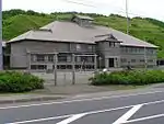 | 44°08′14″N 141°39′19″E | Archived 2020-08-19 at the Wayback Machine |
| Former Shimo-Yoichi Unjōya 旧下ヨイチ運上家 kyū-Shimo-Yoichi unjōya | Hokkaidō | Yoichi | built by the Matsumae Domain to facilitate trade and exchange between the Wajin and the Ainu | 43°11′52″N 140°47′17″E | Archived 2020-08-19 at the Wayback Machine | |
| Shimamaki Fukuroma 袋澗 fukuroma | Hokkaidō | Shimamaki | temporary herring storage facility | 42°44′02″N 140°05′26″E | Archived 2020-08-19 at the Wayback Machine | |
| Yokoyama House 横山家 Yokoyama-ke | Hokkaidō | Esashi | 41°52′01″N 140°07′31″E | Archived 2020-08-19 at the Wayback Machine | ||
| Ishizaki Fishing Port Tunnel 石崎漁港トンネル航路 Ishizaki gyokō tonneru kōro | Hokkaidō | Kaminokuni | 41°42′19″N 140°01′19″E | Archived 2020-08-19 at the Wayback Machine | ||
| Hakodate Fishing Port Entrance Breakwater 函館漁港船入澗防波堤 Hakodate gyokō funairima bōhatei | Hokkaidō | Hakodate | 41°46′24″N 140°42′00″E | Archived 2020-08-19 at the Wayback Machine | ||
| Collection of 67 mudamahagi-type Fishing Boats from the Tsugaru Strait and Surrounding Areas 津軽海峡及び周辺地域のムダマハギ型漁船コレクション67隻 Tsugaru-kaikyō oyobi shūhen chiiki no mudamahagi-gata gyosen korekushon 67-seki | Aomori | Aomori | Important Tangible Folk Cultural Property;[8] at the Aomori Museum of History | 40°50′15″N 140°43′32″E | Archived 2020-08-19 at the Wayback Machine | |
| Fishing Gear and Beach Hut 漁撈用具と浜小屋 gyorō-yō gu to hama-goya | Aomori | Hachinohe | 40°29′42″N 141°37′47″E | Archived 2020-08-19 at the Wayback Machine | ||
| Tsukuehama Fishing Village Banya 机浜漁村番屋群 Tsukuehama gyoson banya-gun | Iwate | Tanohata | 39°58′27″N 141°56′30″E | Archived 2020-08-19 at the Wayback Machine | ||
| Sanriku Tsunami Facilities 三陸津波伝承施設 Sanriku tsunami denshō shisetsu | Iwate | Kamaishi, Miyako | two elements: the Tarō Sea Wall (田老防潮堤) and Ryōishi Tsunami Memorials (両石津波記念碑) | 39°44′06″N 141°58′26″E | Archived 2020-08-19 at the Wayback Machine | |
| Cape Ne Tiger-Ladder Dance and Kurosaki Jinja 根岬はしご虎舞と黒崎神社 Ne-saki hashi go-tora-mai to Kurosaki Jinja | Iwate | Rikuzentakata | the shrine was founded in 1172; the festival takes place every four years on the tenth day of the ninth month of the old lunar calendar, using ladders twenty metres long | 38°57′16″N 141°43′24″E | Archived 2020-08-19 at the Wayback Machine | |
| Shiogama Minato Matsuri and Parade Boat みなと祭りと御座船 Minato matsuri to go-zasen | Miyagi | Shiogama | 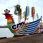 | 38°19′09″N 141°01′44″E | Archived 2020-08-19 at the Wayback Machine | |
| Yuri Coast Sea Wall 由利海岸波除石垣 Yuri-kaigan nami-yoke ishigaki | Akita | Nikaho | 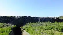 | 39°16′51″N 139°55′18″E | Archived 2020-08-19 at the Wayback Machine | |
| Jūroku Rakan Iwa 十六羅漢岩 Jūroku Rakan iwa | Yamagata | Yuza | 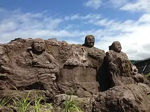 | 39°04′24″N 139°52′05″E | Archived 2020-08-19 at the Wayback Machine | |
| Matsukawa Bay Entrance 松川浦の浦口 Matsukawa-ura no ura-guchi | Fukushima | Sōma | 37°49′34″N 140°58′32″E | Archived 2020-08-19 at the Wayback Machine | ||
| Hitachi Ōtsu Ofuna-matsuri and Festival Boats 常陸大津の御船祭と祭事船 Hitachi Ōtsu no ofuna-matsuri to saiji-sen | Ibaraki | Kitaibaraki | 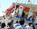 | 36°49′39″N 140°47′02″E | Archived 2020-08-19 at the Wayback Machine | |
| Hobiki-bune 帆びき船 Hobiki-bune | Ibaraki | Itako, Kasumigaura, Namegata, Tsuchiura | 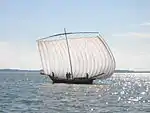 | 36°04′40″N 140°12′31″E | Archived 2020-08-19 at the Wayback Machine | |
| Yamamoto Family Residence 山本家住宅 Yamamoto-ke jūtaku | Ibaraki | Kamisu | 35°53′06″N 140°40′42″E | Archived 2020-08-19 at the Wayback Machine | ||
| History of the Development of the Fishing Industry in Chōshi 銚子漁業開拓の歴史 Chōshi gyogyō kaitaku no rekishi | Chiba | Chōshi | three elements: Kawaguchi Jinja (川口神社), Senninzuka (千人塚), and Tokawa Fishing Village (外川漁村) | .jpg.webp) | 35°44′18″N 140°51′20″E | Archived 2020-08-19 at the Wayback Machine |
| Iwafune Jizō 岩船地蔵尊 Iwafune Jizō-son | Chiba | Isumi | 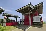 | 35°12′27″N 140°23′35″E | Archived 2020-08-19 at the Wayback Machine | |
| Minamibōsō Whaling Tradition Facilities 南房総捕鯨伝承施設 Minamibōsō hogei denshō shisetsu | Chiba | Kyonan, Minamibōsō | three elements: the Wada Bay Whale Body Treatment Area (和田浦鯨体処理場), Chōshō-ji (長性寺ほか), and Daigo Shinbee Graves and Whale Mound (醍醐新兵衛墓所、鯨塚ほか) | 35°02′09″N 140°00′54″E | Archived 2020-08-19 at the Wayback Machine | |
| Funabashi Daijingū Lighthouse 船橋大神宮灯明台 Funabashi Daijingū tōmyō-dai | Chiba | Funabashi | built in 1880 in the grounds of Ōhi Jinja | 35°12′27″N 140°23′35″E | Archived 2020-08-19 at the Wayback Machine | |
| Sites Related to the Fishing Industry of Edo-Tōkyō: Tsukuda-jima, Nihonbashi, Tsukiji 江戸東京漁業ゆかりの地 佃島・日本橋・築地 Edo Tōkyō gyogyō yukari no chi | Tōkyō | Chūō | 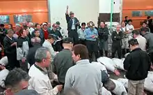 | 35°41′03″N 139°46′37″E | Archived 2020-08-19 at the Wayback Machine | |
| Takamori Lighthouse 高森灯台 Takamori tōdai | Tōkyō | Niijima | 34°19′56″N 139°13′13″E | Archived 2020-08-19 at the Wayback Machine | ||
| Five Wasen 和船5艘 wasen go-sō | Kanagawa | Yokosuka | 35°16′28″N 139°40′25″E | Archived 2020-08-19 at the Wayback Machine | ||
| Fishing Tradition of Manazuru 真鶴の漁業伝統 Manazuru no gyogyō dentō | Kanagawa | Manazuru | two elements: the Kibune Festival Kobaya-bune (貴船まつりの小早船) and Uotsuki Protected Forest (魚つき保安林) (in 1672, concerned by deforestation, the Odawara Domain gave 150,000 pine saplings to each village) | 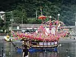 | 35°08′43″N 139°09′10″E | Archived 2020-08-19 at the Wayback Machine |
| Ado-ike 安戸池 Ado-ike | Kagawa | Higashikagawa | popular for mullet-fishing until the Meiji period | 34°14′31″N 134°23′45″E | Archived 2020-08-19 at the Wayback Machine | |
| Minoura Fishing Port 箕浦漁港 Minoura gyokō | Kagawa | Kan'onji | 34°14′31″N 134°23′45″E | Archived 2020-08-19 at the Wayback Machine | ||
| Monument to Kathleen Mary Drew-Baker ドゥルー女史記念碑 Dōrū-jo shi kinen-hi | Kumamoto | Uto | 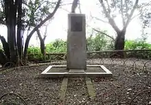 | 32°42′31″N 130°35′25″E | Archived 2020-08-19 at the Wayback Machine | |
| Utase-bune うたせ船 ofuna-yori | Kumamoto | Ashikita | 32°18′05″N 130°28′52″E | Archived 2020-08-19 at the Wayback Machine | ||
| Sakitsu Church 﨑津天主堂 Sakitsu tenshūdō | Kumamoto | Amakusa | Sakitsu Village (崎津集落) is inscribed on the UNESCO World Heritage List as one of the Hidden Christian Sites in the Nagasaki Region[9] | 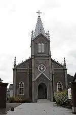 | 32°18′45″N 130°01′33″E | Archived 2020-08-19 at the Wayback Machine |
| Ofuna-yori 御船寄 ofuna-yori | Ōita | Nakatsu | 33°36′41″N 131°11′34″E | Archived 2020-08-19 at the Wayback Machine | ||
| Seven Wonders of Hime-shima 姫島七不思議 Hime-shima nana fushigi | Ōita | Kunisaki | two elements: Ukisu (浮洲) and Sennindō (千人堂) | 33°44′06″N 131°39′10″E | Archived 2020-08-19 at the Wayback Machine | |
| Hoto-jima Village 保戸島集落 Hoto-jima shūraku | Ōita | Tsukumi | 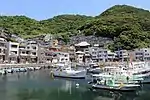 | 33°06′18″N 132°00′25″E | Archived 2020-08-19 at the Wayback Machine | |
| Story of Abaratsu Port 油津の港物語 Abaratsu no minato monogatari | Miyazaki | Nichinan | three elements: the Horikawa Canal (堀川運河); Sugimura Hardware Store Main Building and Storehouse (杉村金物本店主家・倉庫); Choro-bune (チョロ船) | 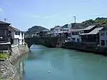 | 31°35′05″N 131°24′07″E | Archived 2020-08-19 at the Wayback Machine |
| Outrigger Utase-bune 桁打瀬船 keta-utase-bune | Kagoshima | Izumi | by 2005 their number had dwindled to 5 | 32°06′56″N 130°17′40″E | Archived 2020-08-19 at the Wayback Machine | |
| Kashima Island Resident Life Centre 鹿島離島住民生活センター Kashima ritō jūmin seikatsu sentā | Kagoshima | Satsumasendai | former headquarters of the local fishing cooperative | 31°46′38″N 129°47′35″E | Archived 2020-08-19 at the Wayback Machine | |
| Hashima Fishing Port 羽島漁港 Hashima gyokō | Kagoshima | Ichikikushikino | 31°45′12″N 130°11′53″E | Archived 2020-08-19 at the Wayback Machine | ||
| Statues of Hara Kō, Developer of the Southern Fisheries 南方漁場の開拓者原耕の像 nanpō gyojō no kaitaku-sha Hara Kō no zō | Kagoshima | Makurazaki, Minamisatsuma | 31°16′14″N 130°17′21″E | Archived 2020-08-19 at the Wayback Machine | ||
| Santinmō - Hakugindō 山巓毛と白銀堂 Santinmō to Hakugindō | Okinawa | Itoman | 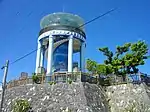 | 26°07′48″N 127°40′13″E | Archived 2020-08-19 at the Wayback Machine | |
| Fish Wall 魚垣 nagaki | Okinawa | Miyakojima | 24°50′09″N 125°08′43″E | Archived 2020-08-19 at the Wayback Machine | ||
References
- 未来に残したい漁業漁村の歴史文化財産百選 [100 Select Fishing Village Heritage Sites to be Preserved for the Future] (in Japanese). National Association of Fisheries Infrastructure. Retrieved 6 August 2019.
- プレスリリース [Press Release] (PDF) (in Japanese). Ministry of Agriculture, Forestry and Fisheries. 17 February 2006. Retrieved 6 August 2019.
- 漁業漁村の歴史文化財産百選 [100 Select Fishing Village Heritage Sites] (in Japanese). Hyōgo Prefecture. Retrieved 6 August 2019.
- 未来に残したい漁業漁村の歴史文化財産百選について [100 Select Fishing Village Heritage Sites to be Preserved for the Future] (in Japanese). Yamaguchi Prefecture. Retrieved 6 August 2019.
- 旧花田家番屋 [Former Hanada Family Banya] (in Japanese). Agency for Cultural Affairs. Retrieved 6 August 2019.
- 旧留萌佐賀家漁場 [Former Rumoi Saga Family Fishery] (in Japanese). Agency for Cultural Affairs. Retrieved 6 August 2019.
- 留萌のニシン漁撈(旧佐賀家漁場)用具 [Rumoi Fishing (Former Saga Family Fishery) Tools] (in Japanese). Agency for Cultural Affairs. Retrieved 6 August 2019.
- 津軽海峡及び周辺地域のムダマハギ型漁船コレクション [Collection of mudamahagi-type fishing boats from the Tsugaru Strait and surrounding areas] (in Japanese). Agency for Cultural Affairs. Retrieved 8 August 2019.
- "Hidden Christian Sites in the Nagasaki Region". UNESCO. Retrieved 7 August 2019.
External links
- (in Japanese) 100 Fishing Village Heritage Sites