1954 Chlef earthquake
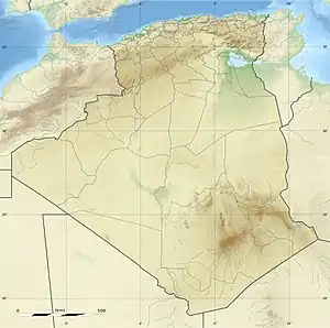
The 1954 Chlef earthquake struck Chlef Province in Algeria on September 9 at 02:04:43 local time. The shock measured 6.7 on the moment magnitude scale and had a maximum Mercalli intensity of XI (Extreme). It destroyed Chlef, then named Orléansville, leaving over 1,243 people dead and 5,000 injured. Damage was estimated at $6 million. It was followed by multiple aftershocks. Algeria faces annual earthquakes and has undergone several changes to its earthquake building codes since its first earthquake engineering regulations from 1717.
 Algiers Oran | |
| UTC time | 1954-09-09 01:04:43 |
|---|---|
| ISC event | 891046 |
| USGS-ANSS | ComCat |
| Local date | September 9, 1954 |
| Local time | 02:04:43 |
| Magnitude | 6.7 Mw[1] |
| Depth | 15 km (9.3 mi)[1] |
| Epicenter | 36.27°N 1.59°E[1] |
| Type | Dip-slip[2] |
| Areas affected | Chlef Province Algeria |
| Total damage | $6 million[3] |
| Max. intensity | XI (Extreme)[3] |
| Tsunami | .33 m (1 ft 1 in)[4] |
| Casualties | 1,243–1,409 dead[4] 5,000 injured[4] |
Geology
Powerful earthquakes strike Algeria annually, ranging in Mercalli intensity scale intensity from VI (Strong) to XI (Extreme).[5] Chlef was hit by another major earthquake in 1980 which killed 3,500 people.[6] The Atlas Mountains area faces aseismic deformation (change in shape not originating from movement of faults), with only marginal plate shifting each year.[6] Both Chlef earthquakes originated from the same reverse fault zone.[2]
The 1954 earthquake measured 6.7 on the moment magnitude scale according to the International Seismological Centre and had a depth of 15 km (9.3 mi). There is evidence of crustal shortening along a NW-SE trend near the epicenter, but the structure of any faults is poorly understood.[7] Because Algeria has a thin shelf and a steep coastal slope, submarine landslides are quite common, especially during earthquakes.[8] During the 1954 earthquake, five underwater telephone cables in the Mediterranean Sea[9] were cut by an avalanche, three recording the exact time of impact.[8]
Damage and casualties
Shaking extended west to Mostaganem, south to Tiaret, and east to Tizi Ouzou, and many aftershocks followed the earthquake, including a major tremor at 22:18 UTC on September 16 which further damaged Orleansville.[9] The main shock ruptured 16 km (9.9 mi) of rock, ripping faults and creating visible fissures in the ground along the Dahra Massif. Survivors described a sensation of rotating along an axis and that the rubble reminded them of "bombed cities in Europe."[10] The United States Geological Survey lists the 1954 quake among the deadliest earthquakes in history.[11] Agence France-Presse (AFP) reported that it was the worst earthquake in North African history.[10]
Aftermath
Orléansville was devastated by the earthquake; a fifth of it wholly destroyed,[12] it was rebuilt and renamed El Asnam and later Chlef.[9] While Algeria had set earthquake resistance regulations as early as 1717, it was the 1954 earthquake that ushered in fully comprehensive reforms for seismic-resistant design.[5]
References
- ISC (2015), ISC-GEM Global Instrumental Earthquake Catalogue (1900–2009), Version 2.0, International Seismological Centre
- Dewey, James W. (1991), "The 1954 and 1980 Algerian earthquakes: Implications for the characteristic-displacement model of fault behavior", Bulletin of the Seismological Society of America, 81 (2): 446
- National Geophysical Data Center / World Data Service (NGDC/WDS) (1972), Significant Earthquake Database (Data Set), National Geophysical Data Center, NOAA, doi:10.7289/V5TD9V7K
- USGS (September 4, 2009), PAGER-CAT Earthquake Catalog, Version 2008_06.1, United States Geological Survey
- Paz, Mario, ed. (1994). International Handbook of Earthquake Engineering: Codes, Programs, and Examples. Springer. p. 57. ISBN 978-0412982118.
- Ambraseys, N.N. (1981). "The El Asnam (Algeria) earthquake of 10 October 1980; conclusions drawn from a field study". Geological Society of London. doi:10.1144/GSL.QJEG.1981.014.02.05. Retrieved September 6, 2013.
- El-Robrini, Gennesseaux, and Mauffret, pg 171.
- El-Robrini, Gennesseaux, and Mauffret, pgs 171–2.
- "Earthquakes with 1,000 or More Deaths Since 1900". United States Geological Survey. November 30, 2012. Archived from the original on January 14, 2013. Retrieved September 6, 2013.
- "1954:Algerian Earthquake: In Our Pages: 100, 75 And 50 Years Ago". The New York Times. Sulzberher, Arthur Ochs Jr. September 10, 2004.
- "Today in Earthquake History: September 9". United States Geological Survey. October 2, 2012. Retrieved September 6, 2013.
- "800 Feared Dead In Algeria Quake; Tremor Rocks 50-Mile Area, Catching People Asleep". The New York Times. Sulzberher, Arthur Ochs Jr. September 10, 1954. Retrieved September 6, 2013.
Sources
- El-Robrini, M.; Gennesseaux, M.; Mauffret, A. (1985). "Consequences of the El-Asnam earthquakes: Turbidity currents and slumps on the Algerian margin (Western Mediterranean)". Geo-Marine Letters. 5 (3): 171–176. Bibcode:1985GML.....5..171E. doi:10.1007/BF02281635.
External links
- The International Seismological Centre has a bibliography and/or authoritative data for this event.