1856 Heraklion earthquake
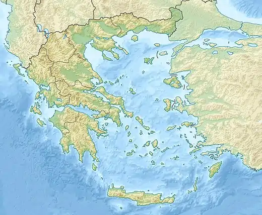
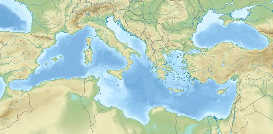
The 1856 Heraklion earthquake, also known as the Crete earthquake or Rhodes earthquake occurred on the morning of October 12 at 02:45 am local time.[1] This extremely catastrophic earthquake had an estimated magnitude of 7.7 to 8.3 at a depth of approximately 61 to 100 km.[2] The earthquake was felt over a very wide area extending from Sicily, Italy to the Levant and North Africa.[3] On the Greek island of Crete, the effects of the temblor was cataclysmic, over 500 bodies were recovered in the city of Heraklion. Shockwaves from the earthquake were felt intensely, covering all of the Ottoman Empire; present-day Turkey, Cyprus and the Middle East where damage and human losses were reported. In Malta, the earthquake collapsed the Għajn Ħadid Tower—a coastal watchtower built around the year 1638. In Cairo, Egypt, the earthquake destroyed buildings, created seiches in canals, and killing ten people. Off the Egyptian coast, sailors were said to have felt a seaquake while along the Lebanese and Palestinian coasts, tsunamis were witnessed.[4]
  | |
| UTC time | 1856-10-12 00:45 |
|---|---|
| Local date | 11–12 October 1856 |
| Local time | 02:38 am or 02:45 am EET |
| Duration | 2 minutes |
| Magnitude | 7.6-8.3 Mw |
| Depth | 61-100 km |
| Epicenter | 35.5°N 26.0°E |
| Type | Intraplate |
| Areas affected | Mediterranean Sea |
| Max. intensity | XII (Extreme) |
| Tsunami | Unlikely |
| Aftershocks | Yes |
| Casualties | 600+ dead 600+ injured |
Tectonic background
Along the southern coast of the Dodecanese Islands, Rhodes, Crete and the Ionian Islands, the African Plate made of oceanic crust is subducting beneath the Aegean Sea Plate (part of the Eurasian Plate) along a convergent plate boundary at a rate of 5 to 10 mm/yr. The interface of the subduction zone occasionally rupture in large megathrust earthquakes such as those in 365 and 1303. Tsunamis are produced along the Hellenic Trench as one side of the fault is suddenly thrust upwards, displacing trillions of gallons of seawater during a massive earthquake.
Earthquake
The Heraklion earthquake of 1856 was an intermediate-depth earthquake with a hypocenter depth of 60 to 90 km, occurring on a fault within the subducting African Plate.[5] The epicenter is most likely located off the northern coast of Crete, based on evaluating where the strongest isoseismic contours were at. For a moment magnitude 7.7 (Mw ) event, the estimated fault dimensions is 64 km by 64 km at a depth of 90 km beneath the Aegean Sea while an 8.1–8.3 Mw would involve a 120 km by 120 km fault rupture at a deeper depth of 130 km.[6]
Effects
The earthquake caused widespread damage not just in Greece, but in the Middle East and North Africa, where additional deaths and damage was reported. An exact time of occurrence is still debated at between 02:38 am or 02:45 am.[7]
Greece
The earthquake reached XI (Extreme) on the Mercalli intensity scale in the central part of Crete. The city of Heraklion was nearly completely destroyed, with only 18 or 40 of the 3,600 houses left standing. The seaside cities of Sitia, Chania was also severely damaged. A total of 538 inhabitants on Crete alone were killed while 637 persons were injured. On the island of Rhodes, several villages were destroyed and the coast experienced uplift. Ground failures were widely observed amidst the destruction. Sixty lives were lost on the island. The island of Thera also reported some damage.[8] In Kasos and Karpathos, 8,000 homes were wiped-out, with about 20 deaths.[9]
On mainland Greece, the cities Ioannina and Kyparissia also felt the quake.
Malta
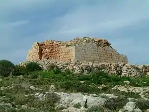
In the Maltese Islands, the earthquake was felt much stronger than most earthquakes from Greece when felt on the islands, making this very unusual and of interest to many seismologists. The quake disrupted the night and woke everyone on the island. The shaking caused some residents to lose their balance and toppled many items in houses. Large cracks developed in the homes of some places such as in Valletta and Gozo.[10] Many churches had cracks in the walls and domes and had hanging crucifixes falling off. In some cases, the damage was more serious, some churches experiencing a total collapse. The dome of Saint Paul's Cathedral in Mdina collapsed from the inside, which caused some ₤1,000 in damages.[11] Damage to structures corresponded to intensity VII. It was this earthquake that collapsed the Għajn Ħadid Tower.
Shaking was felt in Syracuse and Pozzallo, Sicily, Italy where some minor damage occurred.[11]
Egypt
In Cairo, the shaking was still perceivable and strong enough to cause damage. Shaking intensity in the Egyptian capital reached VII to VIII. Three distinct shocks were felt with durations between 1 and 2 minutes. Twenty homes collapsed and another 200 were affected, while some 20 mosques were also crippled. Seiches in canals caused water to splash all over while clocks stopped working as a result of the ground motions. At least four or ten people died in the city. Following the aftermath, many survivors slept outside their homes for fear of a collapse during the night for several days.[12][13]
In Alexandria, only some old construction fell but there were no major implications to the city. Two people were killed and some injuries were sustained to people. Around the Nile Delta, collapses of homes and falling minarets killed an additional number of people in the towns of Tanta and Damanhur.[12][14] In other parts of the delta, many residents found it difficult to stand, which terrified many. Ground motions were strong enough to shift furniture and cause water in tanks to slosh around. Sailors off the coasts reported feeling the strong earthquake as well.[15][16]
Other places
The shock also caused damage to places like Syria and Palestine.
Legacy
In the book Domestic Life in Palestine, author Mary Eliza Rogers described her experience of the strong tremors in Haifa, Israel but she dated the event incorrectly between the night of 10 and 11 October.[7]
See also
References
- Y. Altinok, B. Alpar, N. Özer, C. Gazioglu (2005). "1881 and 1949 earthquakes at the Chios-Cesme Strait (Aegean Sea) and their relation to tsunamis". Natural Hazards and Earth System Science. Copernicus Publications s on behalf of the European Geosciences Union. 5 (5): 717–725. Bibcode:2005NHESS...5..717A. doi:10.5194/nhess-5-717-2005.CS1 maint: multiple names: authors list (link)
- "Seismicity Catalog (550 B.C. - 2010)". Seismological Station. Aristotle University of Thessaloniki. Retrieved 4 January 2021.
- Papadopoulos, Gerassimos & Vassilopoulos, A. (2001). "Historical and Archaeological Evidence of Earthquakes and Tsunamis Felt in the Kythira Strait, Greece.". Tsunami Research at the End of a Critical Decade. Kluwer. pp. 119–183. ISBN 978-90-481-5909-3.CS1 maint: multiple names: authors list (link)
- G. A. PAPADOPOULOS, E. DASKALAKI, A. FOKAEFS and N. GIRALEAS. "TSUNAMI HAZARD IN THE EASTERN MEDITERRANEAN SEA: STRONG EARTHQUAKES AND TSUNAMIS IN THE WEST HELLENIC ARC AND TRENCH SYSTEM" (PDF). Journal of Earthquakes and Tsunamis.CS1 maint: multiple names: authors list (link)
- Papazachos, B. (1996). "Large seismic faults in the Hellenic arc". Annals of Geophysics. 39 (5). doi:10.4401/ag-4023.
- Kkallas, Charalampos, C. Papazachos, A. Skarlatoudis, Chrysanthi, VENTOUZI, D. Boore and B. Margaris. (2018). "Explaining the large anomalous damage patterns of large (M7+) intermediate-depth earthquakes in the southern Aegean Sea" (PDF). 16th European Conference on: Earthquake Engineering Thessaloniki.CS1 maint: multiple names: authors list (link)
- Zohar, M. (2017). "A newly discovered historical earthquake or merely a chronological mistake? Report of Mary Eliza Rogers from October 10, 1856". Journal of Seismology. 21 (5): 1285–1290. Bibcode:2017JSeis..21.1285Z. doi:10.1007/s10950-017-9686-9. S2CID 135012529.
- "Significant Earthquake Information GREECE: CRETE; EGYPT". NGDC. Retrieved 4 January 2021.
- Simon Jusseret, Manuel Sintubin (9 June 2017). Written at Leuven. Earthquakes and Minoan Crete: breaking the myth through interdisciplinarity. Belgium: Leuven University Press. pp. 178–180. ISBN 9789462701052.
- Grech, Herman (2009). "We cannot be complacent about earthquakes - expert". Times of Malta. Retrieved 6 January 2021.
- Galea, Pauline (2007). "Seismic history of the Maltese islands and considerations on seismic risk". Annals of Geophysics. 50 (6).
- Badawy, A., Korrat, I., El-Hadidy, M. (2017). "Update earthquake risk assessment in Cairo, Egypt". J Seismol. 21 (4): 571–589. Bibcode:2017JSeis..21..571B. doi:10.1007/s10950-016-9621-5. S2CID 133402193.CS1 maint: multiple names: authors list (link)
- "Earthquakes in Malta". Maltese History & Heritage. Retrieved 4 January 2021.
- Simon Jusseret and Manuel Sintubin (2013). "The Origins of an Old Myth: Sir Arthur Evans, Claude Schaeffer and the Seismic Destruction of Late Bronze Age Eastern Mediterranean Civilizations". Seismological Research Letters. 84 (1): 94–100. doi:10.1785/0220120098.
- The Seismicity of Egypt, Arabia and the Red Sea: A Historical Review. Cambridge University Press. 1994. ISBN 9780521020251.
- N. N. Ambraseys, C. P. Melville, R. D. Adams (1994). The Seismicity of Egypt, Arabia and the Red Sea: A Historical Review. London: Cambridge University Press. pp. 69–70. doi:10.1017/CBO9780511524912. ISBN 9780511524912.CS1 maint: multiple names: authors list (link)