2017 North Indian Ocean cyclone season
The 2017 North Indian Ocean cyclone season was a below average season in the annual cycle of tropical cyclone formation. This season produced only three named storms, of which one only intensified into a very severe cyclonic storm. The North Indian Ocean cyclone season has no official bounds but cyclones tend to form between April and December with the two peaks in May and November. These dates conventionally delimit the period of each year when most tropical cyclones form in the northern Indian Ocean. The season began with the formation Cyclone Maarutha on April 15 and ended with the dissipation of a deep depression on December 9.
| 2017 North Indian Ocean cyclone season | |
|---|---|
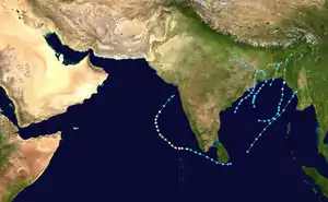 Season summary map | |
| Seasonal boundaries | |
| First system formed | April 15, 2017 |
| Last system dissipated | December 9, 2017 |
| Strongest storm | |
| Name | Ockhi |
| • Maximum winds | 155 km/h (100 mph) (3-minute sustained) |
| • Lowest pressure | 976 hPa (mbar) |
| Seasonal statistics | |
| Depressions | 10 |
| Deep depressions | 6 |
| Cyclonic storms | 3 |
| Severe cyclonic storms | 2 |
| Very severe cyclonic storms | 1 |
| Super cyclonic storms | 0 |
| Total fatalities | 834 total |
| Total damage | $3.65 billion (2017 USD) |
| Related articles | |
The scope of this article is limited to the Indian Ocean in the Northern Hemisphere, east of the Horn of Africa and west of the Malay Peninsula. There are two main seas in the North Indian Ocean – the Arabian Sea to the west of the Indian subcontinent, abbreviated ARB by the India Meteorological Department (IMD); and the Bay of Bengal to the east, abbreviated BOB by the IMD. The official Regional Specialized Meteorological Centre in this basin is the IMD, while the Joint Typhoon Warning Center (JTWC) releases unofficial advisories. On average, three to four cyclonic storms form in this basin every season.[1][2]
Season summary

The season officially had an early start compared with the last two seasons, with the formation of Cyclone Maarutha over the Bay of Bengal in mid-April. Cyclone Mora, formed in late May over the Bay of Bengal. At its peak intensity, it was equivalent to a marginal Category 1 hurricane on the Saffir-Simpson hurricane wind scale. The cyclone produced severe flooding across Sri Lanka, India, Myanmar and Bangladesh and caused 15 deaths directly and 208 deaths indirectly. The floods persisted in Bangladesh since a Deep Depression over Bay of Bengal made landfall and killed 156 people in Bangladesh. A depression formed in northwestern Bay of Bengal and produced torrential rainfall. It was followed by a depression over Jharkhand which killed 70 people in West Bengal. Under the influence of strong monsoon surge a disturbance developed over Bay of Bengal travelled westwards and intensified to an unnamed depression. It also affected neighboring Karachi in Pakistan. A strong monsoon surge prevented formation of systems until a deep depression formed over West Bengal in October and caused heavy rainfall. A couple of depression formed between mid October and November which continued the rain spell causing destruction of life and property. Very Severe Cyclonic Storm Ockhi formed in early December and wreaked havoc in the countries where it impacted. It was equivalent to a strong Category 3 hurricane on the Saffir-Simpson scale at peak intensity. The twin storm of Ockhi was a deep depression which originated in Bay of Bengal while its counterpart was in Arabian Sea.
Systems
Cyclonic Storm Maarutha
| Cyclonic storm (IMD) | |
| Tropical storm (SSHWS) | |
  | |
| Duration | April 15 – April 17 |
|---|---|
| Peak intensity | 75 km/h (45 mph) (3-min) 996 hPa (mbar) |
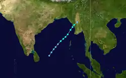
On April 13, an area of low pressure formed in the South Bay of Bengal, under the influence of a persistent area of convection, in a span of six hours.[3] Under favorable conditions, rapid deepening took place, and the system was classified as a depression on April 15.[4] Later on the same day, it further intensified into a Deep Depression, and then into Cyclonic Storm Maarutha. The system moved very fast under the influence of mid-latitude trough in westerlies lying over India in the middle and upper tropospheric levels.[5] However, strong vertical wind shear and unfavourable MJO inhibited rapid intensification or further intensification of the system. Moving northeastwards, it reached its peak intensity in the early hours of 16th. The system maintained its peak intensity till landfall near Sandoway (Thandwe) in Myanmar in the midnight. After landfall, the system weakened into a Deep Depression in early hours of 17th, into a Depression in the morning and well marked low pressure area over central Myanmar and neighbourhood in the forenoon of 17th.[6]
Maarutha had already triggered heavy rainfall as a depression in Sri Lanka, as well as the Andaman and Nicobar Islands (India). Due to a heavy swell in the sea around the Andaman Islands, all ferries to Havelock Island from Port Blair were suspended on leaving nearly 1,500 tourists stranded.[7] In Kyaukpyu, Maarutha destroyed more than 81 households and total damages amounted to Ks31.8 million (US$23,400) as of April 18.[8] Four people were reported to be killed in the Irrawady division of Myanmar.[9][10] Maarutha developed as a depression in the first fortnight of April. Climatologically, the formation of tropical cyclones in the Bay of Bengal at this time of the year is rare. Only twelve Cyclonic Storms have developed over the Bay of Bengal this early in the year between 1891 and 2016.
Severe Cyclonic Storm Mora
| Severe cyclonic storm (IMD) | |
| Category 1 tropical cyclone (SSHWS) | |
  | |
| Duration | 28 May – 31 May |
|---|---|
| Peak intensity | 110 km/h (70 mph) (3-min) 978 hPa (mbar) |
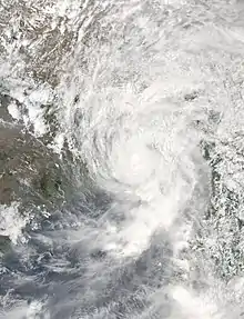
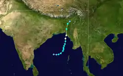
Under the influence of a persistent area of convection, a low-pressure area formed over the southeast Bay of Bengal on May 26.[11] It rapidly strengthened on May 28, with the IMD classifying it as a Depression and subsequently upgrading it to a Deep Depression on the same day, designating it as BOB 02. In the early hours of May 29, the IMD reported the storm to have reached Cyclonic storm intensity, naming it Mora.[11] The storm followed a north-northeasterly track parallel to Myanmar coast. The system moved fast under the influence of mid-latitude trough in westerlies lying over India in the middle and upper tropospheric levels and the anti-cyclonic cyclonic circulation lying to the northeast of the system.[11] Shortly before landfall, the storm reached its peak intensity as a severe cyclonic storm with winds of 110 km/h and a minimum central pressure off 978 hPa (28.9 inHg). The JTWC analyzed it having reached Category 1 hurricane strength on the same day, with winds of 120 km/h. At peak intensity, the storm made landfall on the southern coast of Bangladesh near Chittagong at 6:00 a.m. IST.[11] After landfall, the storm steadily weakened due to land interaction, before weakening into a well-marked low-pressure area over Nagaland on May 31.[11]
A total of 31 people have been killed—9 in Bangladesh and 1 in Myanmar and 19 in Manipur[12][13][14] Damage throughout all the affected countries totalled almost US$1.37 billion.[15][16][17] Two people were reported killed in Malda district of West Bengal.[18]
Additionally, although not directly related to the storm, the precursor low of Mora strengthened the arrival of the monsoon, which caused heavy flooding in Sri Lanka and the Andaman Islands that killed 208 people.
Deep Depression BOB 03
| Deep depression (IMD) | |
  | |
| Duration | June 11 – June 13 |
|---|---|
| Peak intensity | 55 km/h (35 mph) (3-min) 988 hPa (mbar) |
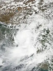
A low pressure area formed over west central & adjoining north Bay of Bengal off north Andhra Pradesh south Odisha coast in the morning of June 10.[19] It concentrated into a well marked low pressure area over northern parts of central Bay of Bengal & adjoining north Bay of Bay on 11th morning and into a depression over north Bay of Bengal in the evening of 11th.).[19] An anti-cyclonic circulation lay to the southeast of the system centre leading to poleward outflow favouring genesis of the system.[19] Moving nearly north-northeastwards, it intensified into a deep depression over north Bay of Bengal in the night of 11th (1800 UTC)and peaked with estimated 3-minute sustained windspeeds of 55 km/h (35 mph).[19] Moving north-northeastwards, it crossed Bangladesh coast near Khepupara between 2300 UTC of 11th and 0000 UTC of June 12.[19] As the system moved over land, it weakened gradually into a depression over east Bangladesh & neighbourhood due to land surface interaction and thereafter into a well marked low pressure area.[19]
At least 156 people have been confirmed dead following landslides caused in the Rangamati, Bandarban and Chittagong districts of Bangladesh along with 14 others in Northeast India caused by torrential rainfall. Cherrapunji received 320 mm rain in association with the system.[20][21] The system helped in the advancement of monsoon over the regions of West Bengal and Odisha. Damages included loss of Tk 18 billion (US$223 million).[22]
Depression BOB 04
| Depression (IMD) | |
  | |
| Duration | July 18 – July 19 |
|---|---|
| Peak intensity | 45 km/h (30 mph) (3-min) 992 hPa (mbar) |
A low pressure area consolidated into a depression over the northwestern and adjoining west-central Bay of Bengal, off the Odisha coast on July 17. The IMD began issuing advisories on the depression, which was very likely to cross the coast by night. The depression moved in a generally northwestwards direction without intensifying, and made landfall on India's Odisha coast, south of Puri, at about 15:00 UTC (20:30 IST) on July 18. Heavy rainfall peaking at Dondilohara in Chhattisgarh receiving 270 mm (11 in)[23] and Dabubagan in Odisha receiving 200 mm (7.9 in)[23] in 24 hours, along with sustained winds of 45 km/h (30 mph) affected the region,[24] causing at least a dozen villages to be submerged in floodwater and five bridges to be washed away.[25] As many as 6,000 people were evacuated in Nabarangpur, and an estimated 65,000 people were directly affected by the dangerous weather.[23][25] By July 31, at least seven people had been killed as a result of the storm.[25] Total losses were estimated at Rs 2187.2 million (US$34 million).[26]
Land Depression 01
| Depression (IMD) | |
  | |
| Duration | July 26 – July 27 |
|---|---|
| Peak intensity | 50 km/h (30 mph) (3-min) 992 hPa (mbar) |
A well-marked low-pressure area over Jharkhand and adjoining the Gangetic West Bengal intensified into a depression on July 26.[27] It moved in a west-northwest direction until degenerated to a well marked low pressure area over east Madhya Pradesh during the next day.[28]
As a precursor low, the storm caused dangerous floods in West Bengal. At least 152 people died,[29] while nearly 2 million people were affected in over 160 villages, which were inundated due to heavy rains. 2,301 people were evacuated from their houses and 202,957 hectares (501,520 acres) of agricultural land were submerged.[30] Around 7,868 houses were entirely destroyed, while 44,361 were partially damaged in West Bengal.[31][32] The state lost around Rs 14000 crores (US$2.18 billion) due to the storm.[33] Eleven people were reported to be killed in Jharkhand, due to the heavy rains.[34] The system caused flooding rains from West Bengal to East Rajasthan. In Jharkhand, Latehar recorded 270 mm (11 in) of rain, and Pratapgarh in Rajasthan recorded 240 mm (9.5 in) of rain, along with sustained winds of 45 km/h.[28] In West Bengal, Halisahar recorded 189 mm.
Land Depression 02
| Deep depression (IMD) | |
  | |
| Duration | October 9 – October 10 |
|---|---|
| Peak intensity | 55 km/h (35 mph) (3-min) 996 hPa (mbar) |
Under active monsoonal conditions, a low pressure area formed over the north Bay of Bengal, near south Bangladesh on October 8.[35] On the following day, the system intensified further into a well-marked low pressure area over the same region, and later, into a depression over the northern Bay of Bengal, near the West Bengal coast.[36] The Madden Julian Oscillation lay over phase 4 with amplitude 1 and these conditions helped in maintaining the intensity of the system and associated convection and thus the storm intensified further into a deep depression later on the same day.[37] An anticyclonic circulation lay over central India in the middle & upper tropospheric levels thus making the system move in a north-northwesterly direction. The storm encountered with strong wind shear, which caused it to weaken rapidly into a low pressure area over west Jharkhand, on October 10.[38]
The system produced heavy rainfall in East India,[39] and also caused 3 deaths in Odisha by lightning and heavy rainfall.[40] The system caused 200 mm of rainfall in Durgapur.[41] Halisahar recorded 105 mm with strong gusty wind of 65 km/h. Kolkata was badly affected by the dangerous weather receiving rain up to 124.4 mm (4.9 in).[42] Strong winds along with incessant rains slowed down traffic, uprooted trees and collapsed buildings.[42] Departure of flights from Kolkata Airport were canceled, due to strong gusty wind of about 70 kmph, at least 23 domestic flights were diverted due to the bad weather.[43] Couple of accidental death also happened due to the rain.[44] An elderly person was electrocuted when he accidentally touched a lamppost. A youth died after an uprooted tree fell on him.[42] Bangladesh was also affected by severe weather conditions. Torrential rain fell, peaking at Jessore receiving 109 mm (4.3 in) in 24 hrs.[45] Maritime ports of Chittagong, Cox's Bazar, Mongla and Payra had been advised in Bangladesh to hoist local cautionary signal number three.[46]
Depression BOB 05
| Depression (IMD) | |
  | |
| Duration | October 19 – October 22 |
|---|---|
| Peak intensity | 45 km/h (30 mph) (3-min) 997 hPa (mbar) |
On October 18, the JTWC noted an area of thunderstorm activity located in the eastern Bay of Bengal as having a partially exposed low level center while located in a marginally favorable environment for further development.[47] Later that day, the IMD upgraded the system to Depression BOB 05 as the system developed formative banding surrounding a center of deep thunderstorm activity.[48][49] Despite being initially forecasted to intensify further, the depression tracked into an environment with strong wind shear and failed to intensify, making landfall on the Odisha coast near Paradip during the afternoon of October 20.[50] After landfall, the system remained near the coastline, allowing moisture incursion from the Bay of Bengal to prevent rapid weakening. Initially tracking northwards, the system soon recurved towards the northeast before weakening into an area of low pressure early on October 22, while located over northeastern Bangladesh, Meghalaya, and southern Assam.[51] [52]
On October 20, the Odisha state government declared the heavy rains caused by the storm as a "State-Specific Disaster". Up to 25 blocks of eight districts in the state had received rainfall exceeding 135 mm (5 in), with the Kanas block of the Puri district recording rainfall of 274 mm (10 in). Heavy damage to homes were reported in Balasore and Bhadrak districts, with an infant reported to have died in the former district following the collapse of a wall.[53][54]
West Bengal was similarly affected by torrential rain, with Kolkata reporting 110 mm (5 in) of rain and the Bankura district reporting 279 mm (10 in). In North 24 pargana district, Halisahar recorded 116 mm and strong winds of about 55 km/h. In the East Midnapore district, a key bridge linking the seaside tourist destinations of Shankarpur and Tajpur collapsed due to strong waves and a storm surge of 1.5 m (5 ft) from the Bay of Bengal as the storm passed through the area. Large portions of the Jamura-Shyampur village near the bridge were similarly reported to have been inundated by the storm surge. In addition, the town of Cherapunji in Meghalaya reported rainfall of 283 mm (10 in) – among the highest reported in association with the depression.[55][56]
In Bangladesh, the ports of Chittagong, Cox's Bazar, Mongla and Payra raised Signal No. 3 as a result of the strong crosswinds and heavy rainfall.[57] Heavy rainfall was witnessed in the country, with the highest total reported at Gopalganj of 279 mm (10 in) of rain.[58]
Depression BOB 06
| Depression (IMD) | |
  | |
| Duration | November 15 – November 17 |
|---|---|
| Peak intensity | 45 km/h (30 mph) (3-min) 1000 hPa (mbar) |
On November 9, an area of low pressure formed in the Bay of Bengal, off the coast of Sri Lanka. The storm moved northwards, but failed to organize further, due to strong wind shear. Conditions later improved while the system moved north-northeastwards, and intensified into a depression on November 15. The IMD subsequently gave the system the identifier BOB 06.[59] On November 17, BOB 06 weakened off the coast of north Odisha into a well-marked low-pressure area as it encountered strong wind shear, with the IMD issuing their final advisory on the system.[60]
Depression BOB 06 caused heavy rainfall, damaging standing paddy crops in Sompeta, Vajrapukotturu, Ichchapuram, Mandasa and some other areas in Srikakulam district in Andhra Pradesh.[61] The system caused heavy rain in Odisha as it tracked along the coastline.[62] Kolkata recorded 53.7 mm rainfall, Digha recorded 60 mm rain while Halisahar recorded 58 mm rain and Diamond Harbour in coastal South 24 Parganas district recorded 50 mm rain as the system moved closer.[63] The rains from the storm caused an epidemic, which caused the death of hundreds of cattle at Gumabirsinghur village in the Ganjam District, in Odisha.[64] As a precursor low, the storm caused heavy rain in Tamil Nadu including Chennai,[65] and caused 20 confirmed fatalities.[66][67]
Very Severe Cyclonic Storm Ockhi
| Very severe cyclonic storm (IMD) | |
| Category 3 tropical cyclone (SSHWS) | |
  | |
| Duration | November 29 – December 6 |
|---|---|
| Peak intensity | 155 km/h (100 mph) (3-min) 976 hPa (mbar) |
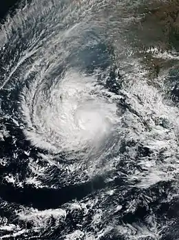
On November 20, the remnant energy of Tropical Storm Kirogi led to the formation of a new low-pressure area over the Gulf of Thailand.[68] During the next several days, the system moved into Bay of Bengal and slowly drifted westward, but the storm was unable to organize significantly, due to unfavorable conditions.[68] On November 29, the storm organized into a depression just off the southeast coast of Sri Lanka, and the IMD gave the storm the identifier BOB 07.[69] Due to the storm's rapidly consolidating low level circulation center the JTWC issued a TCFA on the system, shortly before classifying it as Tropical Cyclone 03B.[70] The IMD followed suite and upgraded the storm to a Deep Depression, and soon afterwards to Cyclonic Storm Ockhi. The storm tracked towards the west-northwest around the southern periphery of a subtropical ridge located over India.[71] The storm tracked westwards, and intensified further into a Severe Cyclone Storm, early on December 1.[72] Soon afterwards, Ockhi intensified further into a Very Severe Cyclonic Storm.[73] On December 2, a 23 mi (37 km) eye formed, prompting the JTWC to upgrade it to a Category 3-equivalent cyclone.[74] But the storm had a sudden turn to the north and the northeast and interacted with a Western Disturbance and a rapid deepening trough along with strong wind shear which deteriorated the overall structure of the storm.[75] It moved further north-northeastwards towards Gujarat coast and encountered cooler sea surface temperatures and dry air intrusion from the Arabian Peninsula and was last noted as a well-marked low-pressure area off the coast of Gujarat.[76]
As a precursor low, the system produced heavy rainfall in Sri Lanka, killing at least 13 people and displacing another 200,000.[77] As a Deep Depression, the system lashed the coast of Tamil Nadu[78] and Kerala, damaging infrastructure, and taking the lives of 72 more people in Kerala[79] and 14 in Tamil Nadu.[80][81]
Deep Depression BOB 08
| Deep depression (IMD) | |
| Tropical storm (SSHWS) | |
  | |
| Duration | December 6 – December 9 |
|---|---|
| Peak intensity | 55 km/h (35 mph) (3-min) 1002 hPa (mbar) |
A low pressure area formed in the Malay Peninsula in early December. The system slowly drifted westwards in the Bay of Bengal, but failed to organize rapidly due to strong wind shear. Warm sea surface temperatures and a pole-ward channel helped the system to consolidate, and on December 6, the IMD initiated advisories on Depression BOB 08, while the JTWC to issued a TCFA on the system,[82] as it intensified to a deep depression. The following day, the system depicted flaring convection to the north of the low level circulation center. At that time the storm was located in moderate vertical wind shear along with moderate poleward outflow. The system steered under the influence of a subtropical ridge.[83] The system produced 40 knots winds in the western quadrant and the JTWC upgraded to a tropical storm. But the storm encountered high wind shear and started to rapidly decay, leading to an exposed low level circulation center with limited convection and shallow banding wrapping into a broad circulation.[84] However an overall weak structure of the storm was noted and it rapidly weakened into a well-marked low-pressure area off the coast of West Bengal and Bangladesh on the evening of December 9.[85]
Due to heavy rains under the influence of the storm paddy harvests died down in some parts of Rupsa block in Balasore and some pockets in Mayurbhanj district in Odisha. Paddy in acres of land was damaged in the rain at Badaopalasa, Bagedihi, Badepataka, Kendua, Olidihai, Burupalsa, Tupaghutu, Segeghutu, Jharadihui, Badakedam, Pokharia, Kuladiha, Rangamatia, Suruda, Anlajodi, Bahalda, Kanki, Basing and Gidighati.[86]
In Bangladesh, the maritime ports of Chittagong, Cox's Bazar, Mongla and Payra had been advised to keep hoisted local cautionary signal no three. All the fishing boats and trawlers over the North Bay had been advised to remain in shelter owing to roughconditions in the sea. At some places of Dhaka, Khulna, Barisal and Chittagong, moderate to heavy rainfall were witnessed from the remnants of the system.[86]
As a precursor low, the system caused massive floods and landslides in Indonesia and Thailand. As of 10 December 20 people were reported killed and 5 remained missing.[86]
Season effects
This is a table of all storms in the 2017 North Indian Ocean cyclone season. It mentions all of the season's storms and their names, duration, peak intensities (according to the IMD storm scale), damage, and death totals. Damage and death totals include the damage and deaths caused when that storm was a precursor wave or extratropical low, and all of the damage figures are in 2017 USD.
| Name | Dates active | Peak classification | Sustained wind speeds |
Pressure | Areas affected | Damage (USD) |
Deaths | Refs |
|---|---|---|---|---|---|---|---|---|
| Maarutha | April 15 – 17 | Cyclonic storm | 75 km/h (45 mph) | 996 hPa (29.41 inHg) | Myanmar, Andaman and Nicobar Islands, Thailand, Yunnan | $23.4 thousand | 4 | [8][9] |
| Mora | May 28 – 31 | Severe cyclonic storm | 110 km/h (70 mph) | 978 hPa (28.88 inHg) | Sri Lanka, Andaman and Nicobar Islands, East India, Northeast India, Bangladesh, Myanmar, Bhutan, Tibet | $297 million | 135 | [13][14][87] |
| BOB 03 | June 11 – 13 | Deep depression | 55 km/h (35 mph) | 988 hPa (29.18 inHg) | Northeast India, Bangladesh | $223 million | 170 | [19][88] |
| BOB 04 | July 18 – 19 | Depression | 45 km/h (30 mph) | 992 hPa (29.29 inHg) | Orissa, Madhya Pradesh, Chhattisgarh | $34 million | 7 | |
| LAND 01 | July 26 – 27 | Depression | 45 km/h (30 mph) | 992 hPa (29.29 inHg) | West Bengal, Jharkhand, Madhya Pradesh | $2.18 billion | 152 | [34][89] |
| LAND 02 | October 8 – 10 | Deep depression | 55 km/h (35 mph) | 996 hPa (29.41 inHg) | Bangladesh, West Bengal, Jharkhand, Odisha, Andhra Pradesh | Unknown | 7 | |
| BOB 05 | October 18 – 22 | Depression | 45 km/h (30 mph) | 999 hPa (29.50 inHg) | Odisha, West Bengal, Northeastern India, Bangladesh | Unknown | 1 | |
| BOB 06 | November 15 – 17 | Depression | 45 km/h (30 mph) | 1000 hPa (29.53 inHg) | Odisha, West Bengal, Andhra Pradesh | Unknown | 20 | |
| Ockhi | November 29 –December 6 | Very severe cyclonic storm | 155 km/h (100 mph) | 976 hPa (28.82 inHg) | Sri Lanka, India, Maldives | $920 million | 318 | [77][80][90] |
| BOB 08 | December 5 – 9 | Deep Depression | 55 km/h (35 mph) | 1002 hPa (29.59 inHg) | Southern Thailand, Northern Malaysia, Aceh, Andaman and Nicobar Islands, Odisha | Unknown | 20 | [91][92][93] |
| Season aggregates | ||||||||
| 10 systems | April 15 – December 9 | 155 km/h (100 mph) | 976 hPa (28.82 inHg) | $3.65 billion | 834 | |||
See also
- Tropical cyclones in 2017
- 2017 Atlantic hurricane season
- 2017 Pacific hurricane season
- 2017 Pacific typhoon season
- South-West Indian Ocean cyclone seasons: 2016–17, 2017–18
- Australian region cyclone seasons: 2016–17, 2017–18
- South Pacific cyclone seasons: 2016–17, 2017–18
- South Atlantic tropical cyclone
Notes
References
- "Annual Frequency of Cyclonic Disturbances (Maximum Wind Speed of 17 Knots or More), Cyclones (34 Knots or More) and Severe Cyclones (48 Knots or More) Over the Bay of Bengal (BOB), Arabian Sea (AS) and Land Surface of India" (PDF). India Meteorological Department. Retrieved October 30, 2015.
- RSMC – Tropical Cyclones New Delhi (2010). Report on Cyclonic Disturbances over North Indian Ocean during 2009 (PDF) (Report). India Meteorological Department. pp. 2–3. Archived from the original (PDF) on December 4, 2010. Retrieved May 24, 2011.
- "Tropical Weather Outlook for North Indian Ocean Issued at 0600 UTC of 13 April 2017" (PDF). India Meteorological Department. Archived from the original (PDF) on April 15, 2017. Retrieved April 15, 2017.
- "Tropical Weather Outlook for North Indian Ocean issued at 0300 UTC of 15 April 2017" (PDF). India Meteorological Department. Archived from the original (PDF) on April 15, 2017. Retrieved April 15, 2017.
- "Tropical Weather Outlook for North Indian Ocean issued at 1400 UTC of 15 April 2017" (PDF). India Meteorological Department. Archived from the original (PDF) on April 15, 2017. Retrieved April 15, 2017.
- "Cyclonic Storm,'Maarutha' over the Bay of Bengal (15-17 April 2017): A Report" (PDF). April 19, 2017.
- "Cyclone Maarutha brings heavy rain in Andamans". May 31, 2017. Retrieved June 1, 2017.
- "Maarutha makes landfall, weakens". The Global New Light of Myanmar. April 18, 2017.
- "Three Die in Cyclone Maarutha". Reliefweb. April 18, 2017. Archived from the original on April 20, 2017. Retrieved April 19, 2017.
- "4 killed as Cyclone Maarutha hits Irrawaddy Delta". May 31, 2017. Archived from the original on June 2, 2017. Retrieved June 1, 2017.
- "Cyclonic Storm "Mora" over Bay of Bengal (28–31 May 2017) : A Brief Report" (PDF). May 30, 2017.
- "Cyclone Mora claims 19 lives in state". July 19, 2017. Archived from the original on August 10, 2017. Retrieved August 10, 2017.
- "Cyclone Mora kills 9 in 4 districts". Dhaka Tribune. May 30, 2017.
- "Cyclone Mora Wreaks Devastation Along Myanmar's West Coast, Killing One". Radio Free Asia. May 31, 2017. Retrieved June 14, 2017.
- "EU announces €1.5 million in assistance to victims of Cyclone Mora in Bangladesh, Myanmar". May 31, 2017. Retrieved June 1, 2017.
- "Manipur floods: State lost Rs 131 crore since Cyclone Mora hit in May". May 31, 2017. Retrieved June 1, 2017.
- "Tourism sector incurs loss of Tk 40 to 45 crore for landslides: Menon". May 31, 2017. Retrieved June 1, 2017.
- "Cyclone kills two in Malda, damages 6,000 houses, mango and litchi orchards". May 31, 2017. Retrieved June 1, 2017.
- Deep Depression over Bay of Bengal (PDF) (Report). India Meteorological Department. July 2017. pp. 1–4. Retrieved November 26, 2017.
- "Landslide, floods kill 156 in Bangladesh, India; toll could rise". ReliefWeb. June 14, 2017. Retrieved June 18, 2017.
- "Floods and landslides in the Northeast, death toll rises to 14 across 3 states". June 14, 2017. Retrieved June 18, 2017.
- "Farmers face taka 1800 crore loss". May 31, 2017. Retrieved June 1, 2017.
- "Depression over Bay of Bengal in July". August 30, 2017.
- "WebCite query result" (PDF). webcitation.org. Archived from the original (PDF) on July 12, 2017. Retrieved July 18, 2017.
- "In Pics: Flood Situation in Odisha worsens, four dead". hindustantimes.com/. July 19, 2017. Retrieved July 19, 2017.
- "Odisha estimates flood damage at Rs 218.72 cr". The New Indian Express. August 9, 2017. Retrieved August 19, 2017.
- "Tropical Weather Outlook for North Indian Ocean by IMD on land depression". India Meteorological Department. October 24, 2017.
- "Tropical Weather Outlook for North Indian Ocean by IMD on land depression". October 24, 2017.
- "63 Killed from floods in south Bengal". Firstpost. August 30, 2017.
- "West bengal state-suffered-rs-14000-crore-loss-in-floods along with 152 dead". The Tribune. April 19, 2017.
- "28 dead, 20 lakh affected in West Bengal floods". July 29, 2017. Retrieved July 29, 2017.
- "31 dead, 20 lakh affected in West Bengal floods". The Hindu. July 29, 2017. Retrieved July 29, 2017.
- "Bengal Floods: 152 Dead, Rs. 14,000 Crore Worth of Damage, Says Banerjee". The New Indian Express. August 21, 2017. Retrieved August 29, 2017.
- "Eight killed as heavy rains lash Jharkhand". hindusthantimes. July 28, 2017. Retrieved July 28, 2017.
- "IMD declares depression over north Bay of Bengal". October 10, 2017.
- "Deep Depression in north Bay of Bengal" (PDF). Indian Meteorological Department. October 10, 2017.
- "Depression in Bay of Bengal". October 9, 2017.
- "Deep Depression in north Bay of Bengal" (PDF). Indian Meteorological Department. October 10, 2017.
- "Depression causes heavy rain in west Bengal". October 9, 2017.
- "Depression over Bay of Bengal caused heavy rain in Hyderabad". October 10, 2017.
- "Depression over Bay of Bengal caused heavy rain in Orissa, Kills 3". October 10, 2017.
- "Heavy rains paralyse Kolkata on Monday". October 10, 2017.
- "23 flights diverted from Kolkata due to bad weather". October 10, 2017.
- "Heavy rains in Kolkata". October 10, 2017.
- "Jessore records 109 mm rain from deep depression". October 10, 2017.
- "Maritime ports in Bangladesh hoist danger signal 3". October 9, 2017. Archived from the original on October 9, 2017. Retrieved October 9, 2017.
- "October 18 Significant Tropical Weather Advisory for the Indian Ocean". Joint Typhoon Warning Center. 2017. Retrieved October 20, 2017.
- "IMD Bulletin No. 1 for Depression BOB 05". October 20, 2017.
- Joint Typhoon Warning Center (October 19, 2017). "October 19 Significant Tropical Weather Advisory for the Indian Ocean". Joint Typhoon Warning Center. Retrieved October 20, 2017.
- "IMD Bulletin No. 2 for Depression BOB 05". October 20, 2017.
- "Significant Tropical Weather Advisory for Indian Ocean on Depression BOB 05". October 20, 2017.
- "Depression in westcentral Bay of Bengal" (PDF). India meteorological Department. October 20, 2017.
- "Odisha classifies heavy rain as State-specific disaster". October 20, 2017.
- "Depression over Bay causes heavy rain in Orissa". October 20, 2017.
- "heavy rain in west Bengal". October 24, 2017. Archived from the original on October 21, 2017. Retrieved October 21, 2017.
- "depression paralyse west Bengal". October 24, 2017.
- "depression affects Bangladesh". October 24, 2017.
- "Heavy rains paralyse Bangladesh". October 10, 2017.
- Neetha K. Gopal (November 15, 2017). "BULLETIN NO. 02: (BOB 06/2017)". India Meteorological Department. Retrieved November 15, 2017.
- Neetha K. Gopal (November 17, 2017). "BULLETIN NO. 012: (BOB 06/2017)" (PDF). India Meteorological Department. Retrieved November 17, 2017.
- "rains damage crops in Srikakulam". Deccan Chronicle. November 24, 2017.
- "Heavy rains in Odisha as depression forms in Bay". Skymetweather. November 24, 2017.
- "Heavy rains lash coastal Bengal". November 24, 2017.
- "Heavy rains lash orissa, causing death of cattle". OrissaPost. November 24, 2017.
- "low causes heavy rain in Chennai, kills 12". ReliefWeb. August 30, 2017.
- "death toll from Chennai rains rises to 20". The Times of India. November 30, 2017.
- "low causing heavy rain in Chennai intensified into a depression". Skymetweather. November 30, 2017.
- "Low from kirogi in Bay of Bengal". Business Line. November 20, 2017. Retrieved November 29, 2017.
- Neetha K. Gopal (November 29, 2017). "BULLETIN NO. 01: (BOB 07/2017)" (PDF). India Meteorological Department. Retrieved November 29, 2017.
- "TCFA issued by JTWC on invest 91B". Joint Typhoon Warning Center. November 20, 2017. Retrieved November 29, 2017.
- Joint Typhoon Warning Center (November 30, 2017). "Significant Tropical Weather Advisory for Tropical cyclone 03B warning #3/30 1800Z-27 1800Z November 2017". Pearl Harbor, Hawaii, United States: National Oceanic and Atmospheric Administration. Archived from the original on May 27, 2017. Retrieved November 30, 2017.
- "IMD Bulletin for Cyclone Ockhi #14". India Meteorological Department. December 1, 2017. Archived from the original on December 1, 2017. Retrieved December 1, 2017.
- "IMD Bulletin for Cyclone Ockhi #16". December 1, 2017. Archived from the original on December 4, 2017. Retrieved December 1, 2017.
- Joint Typhoon Warning Center (December 2, 2017). "Significant Tropical Weather Advisory for Tropical cyclone 03B Warning #10". Pearl Harbor, Hawaii, United States: National Oceanic and Atmospheric Administration.
- Joint Typhoon Warning Center (December 5, 2017). "Significant Tropical Weather Advisory for Tropical cyclone 03B Warning #19". Pearl Harbor, Hawaii, United States: National Oceanic and Atmospheric Administration.
- Joint Typhoon Warning Center (December 7, 2017). "Significant Tropical Weather Advisory for Tropical cyclone 03B Warning #23". Pearl Harbor, Hawaii, United States: National Oceanic and Atmospheric Administration.
- Perera, Amantha. "Will Sri Lanka turn to SMS storm warnings after 'night from hell'?". Reuters. Retrieved December 15, 2017.
- "Cyclone ockhi kills 5 in south India". November 30, 2017.
- http://www.uniindia.com/ockhi-cyclone-death-toll-climbs-to-72/states/news/1076098.html
- "Cyclone Ockhi: Over 600 fishermen of Tamil Nadu, Kerala still missing". The Indian Express. Press Trust of India.
- http://www.firstpost.com/india/cyclone-ockhi-aftermath-tamil-nadu-governor-seeks-assistance-from-centre-for-relief-work-in-kanyakumari-4255459.html
- "Tropical Cyclone Formation Alert-07/0030Z". Joint Typhoon Warning Center. Archived from the original on June 23, 2015. Retrieved December 7, 2017.
- Joint Typhoon Warning Center (November 30, 2017). "Significant Tropical Weather Advisory for Tropical cyclone 04B warning #1/30 1800Z-27 1800Z December 2017". Pearl Harbor, Hawaii, United States: National Oceanic and Atmospheric Administration. Archived from the original on May 27, 2017. Retrieved November 30, 2017.
- Joint Typhoon Warning Center (November 30, 2017). "Significant Tropical Weather Advisory for Tropical cyclone 04B warning #2/30 1800Z-27 1800Z December 2017". Pearl Harbor, Hawaii, United States: National Oceanic and Atmospheric Administration. Archived from the original on May 27, 2017. Retrieved November 30, 2017.
- Joint Typhoon Warning Center (November 30, 2017). "Significant Tropical Weather Advisory for Tropical cyclone 04B warning #3/30 1800Z-27 1800Z December 2017". Pearl Harbor, Hawaii, United States: National Oceanic and Atmospheric Administration. Archived from the original on May 27, 2017. Retrieved November 30, 2017.
- https://in.news.yahoo.com/least-20-killed-5-missing-indonesian-landslides-floods-191604980.html
- "Sri Lanka: UN agency deploys rapid assessment teams to assist in wake of monsoon floods, landslides". May 30, 2017.
- "Death toll up to 146 in Bangladesh landslides". Business Day. South Africa. Agence France-Presse. June 14, 2017. Retrieved June 14, 2017.
- "16 dead, 20 lakh affected in West Bengal floods". July 28, 2017. Retrieved July 28, 2017.
- "Church to take legal action over Indian cyclone tragedy". UCAN India. Retrieved December 18, 2017.
- "Two children die as floods strike Medan". December 5, 2017.
- "Second person dies in Malaysian floods". November 30, 2017.
- "Thailand flood death toll hits 15". December 6, 2017.
External links
| Wikimedia Commons has media related to 2017 North Indian Ocean cyclone season. |