2019–20 North American winter
The 2019–20 North American winter refers to winter in North America as it occurred across the continent from late 2019 through early 2020. Winter weather in the US was a bit on the inactive side as most of the US experienced a warmer than average winter which is all thanks to the strong polar vortex throughout much of the winter. While there is no well-agreed-upon date used to indicate the start of winter in the Northern Hemisphere, there are two definitions of winter which may be used. Based on the astronomical definition, winter begins at the winter solstice, which in 2019 occurred on December 21, and ends at the March equinox, which in 2020 occurred on March 19.[1] Based on the meteorological definition, the first day of winter is December 1 and the last day February 29.[2] Both definitions involve a period of approximately three months, with some variability. Winter is often defined by meteorologists to be the three calendar months with the lowest average temperatures. Since both definitions span the calendar year, it is possible to have a winter storm in two different years.
| 2019–20 North American winter | |
|---|---|
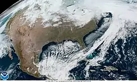 Strong extratropical cyclone brings strong winds and feet of snow to Great Lakes February 27, 2020 | |
| Seasonal boundaries | |
| Astronomical winter | December 21 – March 19 |
| Meteorological winter | December 1 – February 29 |
| Most notable event | |
| Name | November 26 - December 3, 2019 North American blizzard |
| Duration | November 26 - December 3, 2019 |
| Maximum snow accumulation | |
| Highest snowfall total | 114 inches at Homewood, California |
Seasonal forecasts indicated a milder than normal winter across most of the United States and even parts of Canada. These forecasts were verified after the United States experienced their 6th warmest winter on record[3] and many cities in the Northeast Megalopolis received <1" of snow all winter.[4] Fewer significant events occurred during the season and many of them occurred in April and even early May which is quite unusual as most winters tend to have significant winter weather events in January and February. Significant weather events includes an early season winter storm in mainly the northeastern US, a series of brief cold waves in the Northwest and the upper midwest in late January through early February, a historic blizzard in Atlantic Canada in late January, significant lake effect snow in the Great Lakes region late February, a bomb cyclone nor’easter in March that provided a yet another near-miss to the New England region, and a late-season blizzard that impacted the much of the Midwest and the Rockies.
Seasonal forecasts
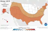
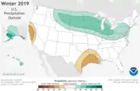
On October 17, 2019, the National Oceanic and Atmospheric Administration's Climate Prediction Center released its U.S. Winter Outlook. The El Niño–Southern Oscillation was in its neutral phase and was thus not expected to be a key predictor for the season. As a result, other oscillations such as the Madden–Julian Oscillation and the Arctic Oscillation were anticipated to be more significant drivers of the seasonal weather, particularly in the form of large temperature and precipitation swings. From the outlook, the greatest likelihoods for above-normal temperatures were for Alaska and Hawaii, with lower but still above-normal odds of above-average temperatures for most of the lower 48 states. The exception was for the Northern Plains, Upper Mississippi Valley, and western Great Lakes regions, which were ascribed equal changes for above-, near-, or below-average temperatures. No area in the United States was favored to have below-average temperatures. In terms of precipitation, wetter-than-average conditions were most likely in Alaska, Hawaii, part of the Northern Plains, Upper Mississippi Valley, Great Lakes, and parts of the Mid-Atlantic and Northeastern U.S. Drier-than-average conditions were favored for Louisiana and parts of Texas, Mississippi, Arkansas, and Oklahoma, as well as parts of central and northern California, with the rest of the U.S. having equal changes of above-, near-, or below-average precipitation. The drought outlook highlighted the presence of abnormally dry conditions across much of the Southern U.S, with improvement expected in part of the Southeast and Mid-Atlantic regions, Alaska, and Hawaii. Drought was expected to persist in central Texas and the Southwestern U.S, with further development anticipated in parts of central California.[5]
Events
Early November winter storm
Record breaking temperatures and snowfall caused disruption throughout the Midwestern United States in early November. Approximately 1000 flights were grounded at Chicago's O'Hare International Airport as 3.7 inches of snow fell on November 11, breaking the previous record of 1.9 inches on November 11, 1995.[6] In areas of Michigan's lower peninsula, over two feet of snow fell.[7] In Canada, Southern Ontario and Southern Quebec had their first major winter storm of the season on November 11 and 12 respectively, which was followed by record January-like cold.[8] 10–20 cm of snow fell across much of the region crippling large cities such as Montreal and Toronto. In Montreal, local officials announced the city's earliest ever snow removal operation in the aftermath of the storm. Over 10 school boards province-wide closed the day after the storm.[9]
Late November–early December blizzard
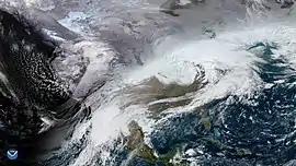
Moving ashore November 26–27 near the Oregon/California border as an over-achieving bomb cyclone, it produced wind gusts in excess of 100 mph near its point of landfall. The storm produced a record low pressure reading of 973.4 millibars in Crescent City, California. From November 27–30, the low merged with the subtropical jet as it tracked slowly eastward across the Rockies, plains & Midwest. The combination of cold air, moisture and high winds produced a wide swath of blizzard conditions from Colorado through western South Dakota, including the Denver Metro. In Rapid City, 14.5 inches of snow fell on the 30th, breaking the one-day snowfall record for November. In Duluth, where 21.7 inches of snow accumulated, it was the city's heaviest snowstorm in 10 years. As the first major winter storm of the season in the northeast, it dumped 22.6 inches of snow in Albany, where it was the heaviest snowfall since the 1993 Superstorm. Widespread totals in excess of 20 inches occurred in the Albany Metro, Southern New Hampshire & Northwestern Massachusetts with a regional peak of 36 inches of snow in New Ipswich, New Hampshire. The low finally moved out to sea December 3.[10]
Early January storm complex
A large complex of low pressure systems began developing January 9 over Central North America. A large trough dug into the jet stream over the Southwestern United States, providing arctic air that had been settled over Canada to move southwards and clash with warm, moist air moving northward from the Gulf of Mexico.[11] In the warm sector, severe thunderstorms and tornadoes broke out in the south central United States on the morning of January 10. Tornado warnings were issued for more than 1.7 million in the Dallas-Fort Worth Metroplex, at 7:52 pm CST a PDS tornado warning was issued for Scranton, Arkansas and surrounding communities and more than 111,000 customers were left without power in Texas alone. Severe weather continued in the deep south into following day, with Alabama being affected particularly severely.[12] North of the boundary, a mix of heavy snow and freezing rain caused travel woes across the Midwest. Along the Great Lakes, winds were forecast to whip up 23 foot waves as lakeshore flooding had already begun in Chicago.[13] Central Michigan through Eastern Ontario received a swath of crippling ice accretion. Several January rainfall records fell in Southern Ontario, as event rainfall totals over 50 mm were widespread, which is highly unusual for that time of year.[14][15]
January–February cold waves
A major arctic outbreak affected western Canada and the Pacific Northwest from January 12–19. Extreme cold warnings were issued across all of Alberta, the Yukon, the Northwest Territories, most of BC, most of Saskatchewan and part of Manitoba during this period, as a cross-polar flow caused arctic air to settle in the region. Much of Central Alberta dipped below -40 °C, colder than it was in Siberia at the time.[16][17]
Following the storm that would go on to become the North Atlantic bomb cyclone, the Ohio River Valley area and parts of the Midwest suffered brutally cold temperatures on January 19.
On February 14, the Ohio River Valley region suffered brutally cold temperatures again this winter with temperatures plummeting to a low of -2 °F at Chicago O'Hare Airport, regionally the coldest temperatures recorded in the 2019–2020 season. Considering the windchill factor, temperatures ranged from -10 °F - -20 °F; dangerously cold for anyone outdoors. It was Chicago's coldest Valentine's Day in 77 years.[18] Temperatures in Minnesota were also record breaking; an overnight low of -35 °F was reported at Preston. New Hampton, Iowa broke a near-century old record when they fell to -18 °F.[19] North of the International border, temperatures fell into the -20 °C range as far south as Toronto, where several frostquakes occurred.[20]
Early February winter storm

On February 4 and 5, snow fell in the deep south, primarily in Texas and Oklahoma, where several highways were closed.[21] Snow fell as far south as Austin, 14 inches of snow fell in Jayton, Texas, and thundersnow occurred in Big Spring. I-70 in central Missouri was temporarily shut down as road crews cleaned debris in the aftermath of a collision. Schools closed in portions of Texas, Oklahoma and Missouri. 9,000 were left without power in the Oklahoma city metro. The following day, severe thunderstorms produced flash flooding and tornadoes in the Southeastern United States. In Simpson County, Mississippi, a possible-tornado destroyed several mobile homes. A PDS-tornado warning was issued for Charlotte, where those at the airport were relocated to the building's interior.[22][23] Severe thunderstorms and tornado warnings occurred as far North as Maryland and Delaware.[24] Winter weather advisories were issued from Tennessee to Maine, with warnings concentrated over North-central Pennsylvania, Western New York, Northern portions of Vermont, New Hampshire and Maine. With a precipitation shield of 2500 km, the storm impacted 16 million across 6 provinces in Canada.[25] The storm was dubbed "Winter Storm Kade" by The Weather Channel.[26]
Mid February Southeast U.S snowstorm
A broad area of low pressure brought snow to parts of the Southeast beginning on February 19, when snow began to fall in the mountains of Tennessee. 4.2 and 4 inches of snow accumulated in Waynesville and Mount LeConte respectively. Similar but slightly lesser amounts occurred in surrounding areas of Eastern Tennessee and Western North Carolina. Another swath of snow occurred in Eastern North Carolina and Southeastern Virginia on February 20–21, ending a 400+ day snow-free streak in the region.[27] In preparation for the storm, most school boards closed or had delayed openings, hundreds of flights were cancelled and all of North Carolina was put under a Winter weather advisory.[28]
Mid-March blizzard
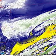
An area of low pressure incoming from the Pacific drifted down the California coastline the week of March 16, bringing scattered thunderstorms with hail to Southern California.[29] Continuous flow of moisture into California's mountains produced extreme snowfall totals during an otherwise unimpressive winter there. 114 inches of snow fell at Homewood, 92" at Sierra-at-Tahoe and 77" at Kingvale, for example.[30] Several rounds of severe thunderstorms occurred in Texas during this time period with the Dallas Metro being especially hit hard. Following >4 inches of rain, street flooding was reported.[31][32] The responsible low pressure area was observed to finally move ashore mid-day on the 18,[33] and the Colorado low began forming shortly afterward. In the Rocky Mountains and Great Plains, blizzard warnings were issued March 17 in anticipation of a very heavy snowfall to be accompanied by strong winds.[34] Snowfall totals in NWS Boulder's forecast region peak at 23 inches 4 miles NE of Nederland.[35] Combined with winds gusting >62 mph,[36] widespread blizzard conditions occurred.[37] At Denver's airport over 1,000 flights or ~80% of air traffic that day, were cancelled.[38]
References
- "Earth's Seasons: Equinoxes, Solstices, Perihelion, and Aphelion, 2000-2025". Washington, D.C.: United States Naval Observatory. March 27, 2015. Archived from the original (PHP) on August 15, 2015. Retrieved August 15, 2015.
- "Meteorological vs. Astronomical Seasons". NOAA National Centers for Environmental Information. June 21, 2013. Retrieved July 3, 2015.
- @NOAANCEIclimate (March 6, 2020). "Just in: Winter ranked 6th warmest on record for the contiguous USA, based on the average temperature observed from December 2019 thru February 2020. @NOAA #StateOfClimate" (Tweet). Retrieved 2020-03-15 – via Twitter.
- "Could a big storm end snow drought in the Northeast this winter?".
- "Winter Outlook: Warmer than average for many, wetter in the North: Drought improvement expected in the Southeast". National Oceanic and Atmospheric Administration. October 17, 2019. Retrieved October 18, 2019.
- "Nearly 1,000 flights canceled as record-breaking snow blankets Chicago". WGN9. Nextstar Broadcasting, inc. 11 November 2019.
- US Department of Commerce. "November 11-12 Accumulating Snow, Lake Effect Snow, and Record-Breaking Cold". www.weather.gov. Retrieved 2020-07-05.
- Inc, Pelmorex Weather Networks. "After strong storm, traffic chaos, where to expect Tuesday's snow". theweathernetwork.com. Retrieved 2020-01-08.
- Inc, Pelmorex Weather Networks. "Quebec digs out from its first major snowstorm of the season". theweathernetwork.com. Retrieved 2020-01-08.
- "Cross-Country Winter Storm Brought Snow, Ice and Wind Thanksgiving Week Into Early December (RECAP)". The Weather Channel. Retrieved 2020-01-08.
- "Winter Storm Closes Schools, Airlines Prepare for Delays". The Weather Channel. Retrieved 2020-01-11.
- "LIVE: Storms leave behind trail of damage as severe weather outbreak advances east".
- "Waves More Than 20 Feet High Could Hit Chicago Lakeshore as Winter Storm Pounds Plains, Upper Midwest". The Weather Channel. Retrieved 2020-01-11.
- Inc, Pelmorex Weather Networks. "Ontario: Largest temperature drop in almost two years, freezing rain ramps up". theweathernetwork.com. Retrieved 2020-01-11.
- Inc, Pelmorex Weather Networks. "PHOTOS: Cleanup underway after record rainfall floods streets, ice topples trees". theweathernetwork.com. Retrieved 2020-01-12.
- Inc, Pelmorex Weather Networks. "Prairies: Temperatures will be among lowest on Earth with intense deep freeze". theweathernetwork.com. Retrieved 2020-01-25.
- "Canadian Prairies locked in icy grip of winter too cold for penguins".
- "Friday is Chicago's coldest Valentine's Day in 77 years". WGN-TV. 2020-02-14. Retrieved 2020-02-14.
- "Deep freeze brings AccuWeather RealFeel Temps as low as minus 46 F".
- Inc, Pelmorex Weather Networks. "Did you hear it? Frost quakes rumble through southern Ontario". theweathernetwork.com. Retrieved 2020-02-15.
- "Snowfall blankets Texas, Oklahoma; Deep South to see storms". keyc.com. February 6, 2020. Retrieved 2020-02-05.
- "'Particularly dangerous situation' tornado warnings prompted by severe storms marching across Southeast".
- "Portion of Interstate 70 Shut Down in Missouri as Winter Storm Marches East". The Weather Channel. Retrieved 2020-02-05.
- @NWStornado (February 7, 2020). "NWS Tornado twitter" (Tweet) – via Twitter.
- Inc, Pelmorex Weather Networks. "Nearly HALF the population of Canada is riding out this big storm". theweathernetwork.com. Retrieved 2020-02-08.
- "Winter Storm to Intensify With Heavy Snow, Some Ice In Northeast, But Will Leave New York, Philly, Washington All Wet". The Weather Channel. Retrieved 2020-02-07.
- "North Carolina feels wintry blast as 437-day snow drought ends".
- "Winter Storm Closes Schools, Cancels Flights in North Carolina, Virginia; Officials Warn of Hazardous Road Conditions". The Weather Channel. Retrieved 2020-02-21.
- Angeles, NWS Los [@NWSLosAngeles] (March 17, 2020). "Convective showers observed moving through LA County this afternoon. Have had reports of hail in some areas, including Woodland Hills. #SoCal #LArain #LAweather" (Tweet). Retrieved 2020-03-18 – via Twitter.
- Boyer, Brittany [@Brittany_Boyer] (March 17, 2020). "Incredible snow totals coming in from the multi-day event in California. They definitely needed it after the lack of snow prior to this #cawx" (Tweet). Retrieved 2020-03-18 – via Twitter.
- @StormOfCorn (March 18, 2020). "For the 2nd time in under 60 hours, flash flooding led to trouble in the Dallas area. Here are 5 locations that picked up at least 4" of rain with last night's event in North Texas. Most of these communities are in the Dallas-Fort Worth metro. More storms are expected. #txwx" (Tweet) – via Twitter.
- @BillWadell (March 18, 2020). "We're finding flooding and street closures in Dallas, Texas this morning after heavy rain overnight. More rain and storms are expected in North Texas over the next 48 hours" (Tweet) – via Twitter.
- @NWSSanDiego (March 18, 2020). "The visible satellite loop this morning shows the compact circulation of the upper low moving into northern Baja. #SanDIegoWX" (Tweet) – via Twitter.
- "Blizzard Warnings Issued in Wyoming and Nebraska as a Winter Storm Will Blast the Rockies, Plains". The Weather Channel. Retrieved 2020-03-18.
- @NWSBoulder (March 20, 2020). "Snowfall totals from 8"-18" in the mountains and foothills with local amounts over 20" in a few spots. Along the I-25 Corridor 5" to 10" around Denver with up to 12" over the Palmer Divide. #cowx" (Tweet). Retrieved 2020-03-20 – via Twitter.
- @NWSBoulder (March 19, 2020). "List of peak wind reports: Akron airport checks in w/the strongest gust of 62 mph . Snow combined w/snow has created widespread blizzard conditions. Numerous locations across the northeast plains have been reporting whiteout or near whiteout conditions. #COwx" (Tweet). Retrieved 2020-03-20 – via Twitter.
- @NWSBoulder (March 19, 2020). "Blizzard conditions exist over a large chunk of northeast Colorado (east of I-25 and over the Palmer Divide). More technical discussion attached in this tweet. #COwx" (Tweet). Retrieved 2020-03-20 – via Twitter.
- "Winter Storm Takes Aim on the Plains, Upper Midwest with Snow and Gusty Winds". The Weather Channel. Retrieved 2020-03-20.
![]() This article incorporates public domain material from websites or documents of the National Oceanic and Atmospheric Administration.
This article incorporates public domain material from websites or documents of the National Oceanic and Atmospheric Administration.
External links
- 2019 Storm Summaries from the Weather Prediction Center
| Preceded by 2018–19 |
North American winters 2019–20 |
Succeeded by 2020–21 |