2020–21 North American winter
The 2020–21 North American winter refers to winter in North America as it is occurring across the continent from late 2020 through early 2021. Similar to some recent winters, a developing La Niña pattern is expected to influence the majority of the winter in North America. So far in the season, several notable winter weather events have unfolded, including a crippling ice storm in the Southern Plains, a powerful nor'easter which impacted the Mid-Atlantic and New England states in December, another major nor'easter in February, a strong blizzard in the Midwest during Christmas Week, and snow in parts of the South.
| 2020–21 North American winter | |
|---|---|
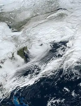
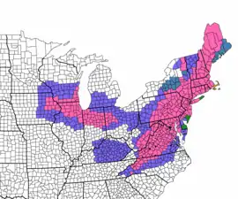 Winter weather alerts across the Northeastern United States in preparation for a powerful nor'easter on January 31, 2021. | |
| Seasonal boundaries | |
| Astronomical winter | December 21 – March 20 |
| Meteorological winter | December 1 – February 28 |
| Most notable event | |
| Name | January 31 – February 3, 2021 nor'easter |
| Duration | January 25 – February 3, 2021 |
| Maximum snow accumulation | |
| Highest snowfall total | 107 in (270 cm) (Mammoth Mountain Ski Area, California) |
| Event | January 25–29, 2021 |
While there is no well-agreed-upon date used to indicate the start of winter in the Northern Hemisphere, there are two definitions of winter which may be used. Based on the astronomical definition, Winter begun at the winter solstice which occurred on December 21, 2020. The winter ends at the spring equinox which will occur on March 20, 2021.[1] Based on the meteorological definition, the first day of winter was on December 1 and the last day will be February 28.[2] Both definitions involve a period of approximately three months, with some variability. Winter is often defined by meteorologists to be the three calendar months with the lowest average temperatures. Since both definitions span the calendar year, it is possible to have a winter storm in two different years.
Seasonal forecasts
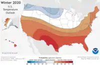
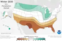
On October 15, 2020, the National Oceanic and Atmospheric Administration's Climate Prediction Center released its U.S. Winter Outlook.[3] The temperature and precipitation outlooks reflected the likelihood of a La Niña pattern developing during most of the winter. The forecast called for warmer than average temperatures across much of the southern and southwestern United States, as well as the East Coast, with cooler than average temperatures in the far northwestern United States. Near-average temperatures were expected in the Midwest. The forecast also called for drier than average conditions across almost all of the southeastern and southwestern United States, and wetter than average conditions in much of the northern tier and Midwest, with near-average precipitation in the Northeast and parts of the Midwest.[3]
Seasonal summary
Winter weather events began in late October in North America, with a crippling and devastating ice storm in the Southern Plains, which later merged with the remnants of Hurricane Zeta and produced more snow in New England.[4] November was generally quiet in terms of winter weather, with a few minor snow events in the Midwest. Late in the month however, a storm system moved through the Ohio Valley bringing over 9 inches (23 cm) of snow to Cleveland, and over 24 inches (61 cm) of snow to areas just south of Lake Erie in northeast Ohio.[5] December began with a bomb cyclone that impacted parts of New England with heavy snow.[6] Later in the month, a powerful nor'easter brought heavy and impactful snow to widespread areas of the Northeastern United States and southern Canada. Major cities such as New York City, Pittsburgh, and Boston saw over 10 inches (25 cm) of snow from the system. Areas farther inland saw as much as 44 inches (110 cm) of snow.[7] Around Christmas week, a powerful blizzard impacted the Midwestern United States and Canada, which also caused severe storms in the Southeast.[8][9] A powerful extratropical cyclone in the Bering Sea late in the month reached winds of over 100 mph (160 km/h) and a minimum central pressure of 921 mb (27.2 inHg) west of Alaska. It later moved on to hit Alaska, after only slightly weakening, causing high surf and gusty winds in the Aleutian Islands.
January and the new year began with a storm system moving from the Gulf of Mexico to the Northeast on New Year's Eve and New Year's Day. It produced a swath of wintry weather extending over 2,000 miles, and the system also produced up to 2 feet (24 in) of snow and over 0.5 inches (13 mm) of ice in some areas.[10] Later in the month, a storm originating in the Rocky Mountains produced a swath of wintry weather from New Mexico through Alabama, including areas such as Lubbock, Austin, Metro Houston, and Shreveport, some of which saw over 6 inches of snow accumulation.[11] Towards the middle of the month, a blizzard impacted the Midwest and the interior Northeast, producing heavy snow and extremely gusty winds behind the system.[12] During the last full week of January, a storm with winter weather spanning over 1,500 miles produced snowfall and mixed precipitation from the Midwest to the Northeast, as well as causing severe weather in the Southeast.[13][14] Towards the end of the month, a storm complex and atmospheric river event began to unfold in the Western United States, especially in California. Snowfall totals were as high as 107 inches (270 cm) and rainfall totals were over a foot in many areas, with extremely heavy rain causing flooding and mudslides in burn scar areas, and extremely heavy snow was consistently dumped on higher elevation areas of the Sierra Nevada.[15] The storm system moved into the Midwest and Ohio Valley, bringing a widespread swath of 5–12 inches (13–30 cm) of snow. The system then became a nor'easter bringing heavy and impactful snow to both coastal and interior areas of the Northeast, with both the Boston and New York City metropolitan areas seeing 18–24 inches (46–61 cm) of snow.[15]
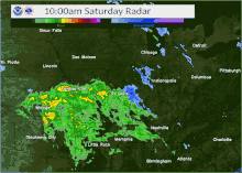
February began with a winter storm that moved through the Great Plains, with heavy snow and blizzard-like conditions sparking a crash on Interstate 80 eastbound in Iowa. More than 40 vehicles were involved in the crash, and serious injuries were reported. Iowa State Police troopers checked on vehicles for deaths or injuries, and a images showed that a state police patrol car was damaged from a flipped semi-trailer.[16]
Events
Late October winter storm
On October 27, a winter storm delivered heavy snow to Colorado, New Mexico, Western Texas, and Kansas, while a crippling ice storm hit Central Oklahoma, and Western North Texas including Oklahoma City. Ice accumulations were as high as 2 inches (51 mm) in areas of the Oklahoma City metropolitan area. The system was unofficially named "Winter Storm Billy" by The Weather Channel.[4]
Post-Tropical Cyclone Zeta

The winter storm that was referred to as "Billy" by The Weather Channel would merge with the remnants of Zeta, and the merger produced more snow in parts of southern New England and upstate New York on October 30.[17][18] The highest amount of accumulation was 6.5 inches (17 cm), which was recorded in Grafton, Massachusetts.[19] This early-season snowstorm resulted in some downed tree branches in the region.[20] The snowstorm also caused slippery road surfaces, leading to numerous crashes, some serious, in the state of Massachusetts.[21]
Early December bomb cyclone
On December 4, a rapidly intensifying cyclone developed from an area of low pressure moving off the Mid-Atlantic coast. Ahead of the storm, Winter Storm Warnings were issued in a swath from the northern parts of Connecticut and Rhode Island to Maine's border with Canada. On December 5, the nor'easter made landfall in coastal New England while brushing the coastline. Precipitation initially began as heavy rain but as the storm progressed northward, heavy wet snow broke out in Massachusetts, New Hampshire and Maine, resulting in over 280,000 customers without power. 12.5 inches of snow fell in Paxton, Massachusetts, and areas in Maine saw up to 18 inches of snow.[22][23] By midday December 6, only flurries lingered over the Northeast, as the storm was moving deeper into Eastern Canada.[6]
Mid-December nor'easter
On December 16, a major nor'easter began affecting parts of New England and the Mid-Atlantic.[24] The storm was unofficially referred to as "Winter Storm Gail" by The Weather Channel and described as a "blockbuster storm" by AccuWeather. The nor'easter formed on December 16 and continued affect the Northeast into the 17th. A swath of 12–18+ inches of snow extended from central Pennsylvania through most of southern New England. Locally, up to 44 inches of snow fell in Newark Valley, New York and 45 inches fell in Ludlow, where a new state record may have been broken. In nearby Pennsylvania, the 24-hour snowfall record of 38 inches was threatened. Williamsport and Binghamton both saw their largest snowstorms on record. Snowfall rates in the latter reached 5 inches per hour at the peak of the storm.[7] Coastal Massachusetts experienced high winds, exceeding 60 mph in gusts, along with the snowfall, causing significant blowing snow.[25] Major cities saw much less but still disruptive amounts of snow, including amounts in Washington D.C. (2.3 inches), Philadelphia (6.3 inches), New York City (10.5 inches), Pittsburgh (11.5 inches),[26] and Boston (12.7 inches), ending a 1,000+ day high-impact snowstorm drought in the Mid-Atlantic and coastal New England regions.[27] More than 70 million people were affected throughout the Northeast. The nor'easter also caused significant impacts in Atlantic Canada; schools, government offices, public parks and recreation programs in the city of Halifax, Nova Scotia all had delayed openings or closures on December 18.[28]
Christmas Week blizzard
A powerful blizzard began impacting the Upper Midwest starting on December 23, disrupting travel ahead of Christmas. A pileup occurred on Interstate 29 in South Dakota, implicating 20 vehicles and injuring a few people. 298 flights were cancelled and another 46 delayed at Minneapolis-St. Paul International Airport. Strong winds, gusting up to 68 mph,[29] left 10,000 customers without power in Minnesota. Almost zero visibility was reported on highways in South Dakota, Minnesota, and Nebraska, as Highway Patrol warned people to stay off the roads.[8][9] Locations in far northern Minnesota and Wisconsin accumulated over a foot of snow.[29] The storm system responsible for the blizzard also brought severe weather to the East Coast; the Storm Prediction Center issued an "Enhanced" risk of severe weather for eastern North Carolina and nearby portions of South Carolina and Virginia on December 24.[30] Five tornadoes were reported in the Southeastern U.S. on December 23; another one was reported as well on December 24, and non-tornadic wind damage was reported across several states.[31][32]
Late December Bering Sea cyclone
In late December, an extremely powerful extratropical cyclone developed in the far Northern Pacific Ocean, and explosively deepened late on December 30–31 as it neared the Bering Sea.[33] According to the Ocean Prediction Center’s analysis, the cyclone achieved a minimum pressure of 921 mb (27.2 inHg) at 12:00 UTC on December 31, which was the lowest pressure ever observed within the Bering Sea since a similar cyclone in November 2014 spawned by the remnants of Typhoon Nuri.[34] Hurricane force wind warnings were issued for parts of the Aleutian Islands as well.
New Year's storm complex
An upper-level low formed in the Gulf of Mexico and came ashore on December 30–31, and snow, freezing rain and sleet began to fall on December 30, prompting winter storm warnings across the West Texas region and extending into Oklahoma.[35] The unusual severity of the winter weather led to the closure of Interstate 10, which stranded dozens of travelers that had to seek shelter in two school gyms in Marfa.[10] Peak accumulations in Texas reached 14 inches in Big Spring. The storm system continued moving Northeastward and brought 5.1 and 6.5 inches to Oklahoma City and Witchita, Kansas respectively. Nearly half an inch of ice accumulated in parts of Illinois and Pennsylvania.[36] Along the Canadian border with Upstate New York and Vermont, up to 7 inches of snow fell.[37] The swath of wintry weather extended over 2,200 miles.[38] The storm caused over 100,000 power outages in the United States.[36]
Early January southern winter storm
On January 10–11, moderate to heavy snow fell across parts of Texas, Louisiana, Arkansas, Mississippi and Alabama. In Texas, several counties had multiple reports of > 6 inches of snowfall accumulation, including the Metro Houston area. The peak accumulation for this storm was 8.5 inches in Madison County, Texas.[39] 150,000 customers were left without power across Texas and Louisiana. Interstates 49 and 220 near Shreveport were briefly closed. Some bridges needed to be treated in Jackson, Mississippi.[11] The storm then passed through Northern Alabama and Southern Tennessee, where it brought up to an inch of snow on grassy surfaces.[40]
Mid-January blizzard
On January 12, a low pressure came ashore in the Pacific Northwest, causing heavy rain, mountain snow, and damaging winds in much of Washington, Oregon and British Columbia. The next day, the system caused a damaging windstorm just east of the Rocky Mountains, with gusts of up to 125 mph (201 km/h) in some areas.[41] It then moved into the Great Plains and Upper Midwest, bringing damaging winds along with heavy snow, prompting Winter Storm and Blizzard Warnings in many of those areas. The surface low pressure later moved into the Upper Midwest, bringing blustery conditions and snow to much of the area.[12] The low pressure stalled on January 15, and blizzard conditions continued in parts of the Upper Midwest. Winter Weather Advisories and Winter Storm Watches were issued in portions of the interior Northeast, in anticipation of the storm moving there next. Later, Winter Storm Watches in the Northeast were upgraded to Winter Storm Warnings as the storm moved into the Northeast. The precipitation was generally all rain along the coast, but interior sections saw some snow from the system.[42] Major Canadian cities such as Ottawa, Montreal, and Quebec City saw over 20 cm (7.9 in) of heavy wet snow on January 15–17,[43] causing 46,000 customers to lose power in Quebec.[44]
Late January–early February nor'easters
Following a series of much weaker winter storms impacting the United States, another arrived on the West Coast. The night of January 26 into January 27, Northern California experienced extreme wind gusts, peaking at 125 mph (201 km/h) near Alpine Meadows.[45] The winds downed trees onto powerlines and homes,[46] causing >400,000 customers to lose power. Additionally, the storm caused an atmospheric river event over parts of the state still recovering from burn scars due to the previous wildfire season, causing several mudslides, one of which destroyed a portion of Highway 1.[47] The combination of extreme winds and extremely intense precipitation caused blizzard conditions near Weed.[15] Once the storm system began to move inland, Winter Storm Watches were issued in some areas of the Midwest and Ohio Valley.[48] 12.9 inches of snow fell in Romeoville. Also, 10.8 and 11.3 inches of snow fell at O'Hare and Midway airports respectively.[49] Nearby, 8 to 10 inches fell in the Milwaukee metro area and 13.5 inches fell in northern Indiana.[50] Shortly thereafter, the storm developed into a nor'easter and began moving up the coast slowly, dumping excessive amounts of snow on the I-95 corridor. 4.5 inches of snow fell in D.C., 5.2 inches in Baltimore,[51] 7.8 inches in Philadelphia,[52] 17.2 inches in Central Park, New York, 15.2 inches in New Haven, and 24 inches in Lowell, Massachusetts.[53] The highest snowfall total from the nor'easter phase of the storm was 36.1 inches in Nazareth, Pennsylvania.[52] The storm was unofficially named "Winter Storm Orlena" by The Weather Channel as part of their annual naming scheme.
Another nor’easter began taking shape late on February 6 in the form of a low pressure system off the coast of South Carolina. Ahead of the storm, winter storm warnings were issued from Georgia to Massachusetts.[54] Snow broke out in interior portions of the Carolinas and Virginia; Saluda, North Carolina and Wise, Virginia picked up 6.3 and 8 inches respectively. Then the storm's effects moved up into the I-95 corridor, where totals exceeding 6 inches were widespread. 9.1 inches was reported near Westwood, New Jersey, 6.5 inches at JFK International Airport, 8 and 7.4 inches at North Haven and Bridgeport Airport in Connecticut, 14 inches at Pascoag, Rhode Island and 12 inches in Norfolk, Massachusetts. The storm was unofficially named "Winter Storm Quade" by The Weather Channel as part of their annual naming scheme.[55][56] Afterwards, the storm affected Atlantic Canada, where up to 50 cm of snow fell in Halifax. As a result, across the entire region, public transportation was shutdown, government offices and schools were closed, postal services were delayed and the regular ferry crossing service in the Cabot Channel was suspended.[57][58]
Early February cold wave
Wind chill advisories and wind chill warnings have been issued from eastern Montana into Wisconsin and all the way to northern Illinois. On February 7, in International Falls, Minnesota, the wind chill was −46 °C (−51 °F) early in the day[59] and the following morning, the actual temperature fell to −40 °F (−40 °C) in Ash Lake, Minnesota.[60] Meanwhile, in British Columbia (Canada), a woman in Dawson Creek, where the temperature was −42.2 °C (−44.0 °F) at the time, died of prolonged exposure to the cold.[61]
See also
References
- "WebCite query result". www.webcitation.org. Retrieved 2020-10-16.
- "Meteorological vs. Astronomical Seasons". NOAA National Centers for Environmental Information. June 21, 2013. Retrieved July 3, 2015.
- "U.S. Winter Outlook: Cooler North, warmer South with ongoing La Nina | National Oceanic and Atmospheric Administration". www.noaa.gov. Retrieved 2020-10-19.
- "Winter Storm Spreading Snow and Damaging Ice Through the Southern Plains | The Weather Channel - Articles from The Weather Channel | weather.com". The Weather Channel. Retrieved 2020-12-20.
- "Blog: An updated look at school closings in Northeast Ohio". December 1, 2020.
- "Weekend Nor'easter Winding Down After Knocking Out Power in New England | The Weather Channel - Articles from The Weather Channel | weather.com". The Weather Channel. Retrieved 2020-12-06.
- "Winter Storm Gail Was a Record Snowstorm for Two Northeast Towns | The Weather Channel - Articles from The Weather Channel | weather.com". The Weather Channel. Retrieved 2020-12-17.
- "Whiteout Conditions Trigger Multicar Pileups, Crashes Across South Dakota, Nebraska, Minnesota | The Weather Channel - Articles from The Weather Channel | weather.com". The Weather Channel. Retrieved 2020-12-24.
- "Whiteouts create dangerous travel as blizzard blasts central US".
- "Hundreds Stranded When Winter Storm Shuts Down West Texas Highways | The Weather Channel - Articles from The Weather Channel | weather.com". The Weather Channel. Retrieved 2020-12-31.
- "150,000 Without Power as Winter Storm Dumps Snow Across Texas and the South | The Weather Channel - Articles from The Weather Channel | weather.com". The Weather Channel. Retrieved 2021-01-12.
- https://weather.com/storms/winter/video/snowy-system-prompts-winter-weather-alerts
- "Massive storm unloads snow, ice from Nebraska to Pennsylvania, New York". AccuWeather. Retrieved 26 January 2021.
- https://weather.com/storms/winter/video/snow-and-ice-remain-a-threat-through-tomorrow
- "California Atmospheric River Bringing Threat of Flooding, Debris Flows and Feet of Sierra Snow | The Weather Channel - Articles from The Weather Channel | weather.com". The Weather Channel. Retrieved 2021-01-27.
- "Serious injuries reported after massive 40-vehicle pileup on snowy section of I-80 in Iowa". CBS News. February 4, 2021. Retrieved February 5, 2021.
- "First Snow of Season to Arrive in New England Friday". NBC Boston. Retrieved 2020-12-20.
- "Coronavirus Coffee Break: First Snowfall in New England". NBC New York. Retrieved 2020-12-20.
- "Who got the most snow in Massachusetts?". masslive. October 30, 2020.
- "New England Sees First Snow of the Season (PHOTOS) | The Weather Channel - Articles from The Weather Channel | weather.com". The Weather Channel.
- "Snow Shocks Region, Causes Serious Crashes: Patch PM". Worcester, MA Patch. October 30, 2020.
- Madeline Holcombe. "First nor'easter of the season leaves 280,000 power outages, treacherous roads in its wake". CNN. Retrieved 2020-12-06.
- https://twitter.com/NWSEastern/status/1335636433416187908
- "7 dead as winter storm hits Northeast with 3 feet of snow". NBC News. Retrieved 2020-12-20.
- "See the nor'easter's impact: Mass. residents post images of winter storm". masslive. 2020-12-17. Retrieved 2020-12-17.
- "Map charting unofficial snowfall accumulations across the region". Twitter. December 17, 2020. Retrieved January 1, 2021.
- "Bitter cold following monster snowstorm may lead to dangerous conditions".
- "Storm closures and cancellations: Dec. 18, 2020". HalifaxToday.ca. Retrieved 2020-12-18.
- US Department of Commerce, NOAA. "December 23rd Blizzard Summary". www.weather.gov. Retrieved 2020-12-25.
- "NWSSPC Twitter".
- "Storm Prediction Center 201223's Storm Reports". www.spc.noaa.gov. Retrieved 2020-12-25.
- "Storm Prediction Center Today's Storm Reports". www.spc.noaa.gov. Retrieved 2020-12-25.
- Mersereau, Dennis. "One Of The Strongest Storms In Years Will Brush Alaska This Week". Forbes. Retrieved 2021-01-01.
- US Department of Commerce, NOAA. "National Weather Service Text Product Display". forecast.weather.gov. Retrieved 2021-01-01.
- "WATCH: Snow Falls in West Texas; Travel Advisory Warns of 18 Inches of Accumulation". NBC 5 Dallas-Fort Worth. Retrieved 2020-12-31.
- "New Year's Storm Brings Mess of Snow and Ice From the Midwest to New England | The Weather Channel - Articles from The Weather Channel | weather.com". The Weather Channel. Retrieved 2021-01-02.
- "NWS Burlington Twitter".
- "Travel hazards will linger into new year even after Northeast storm recedes".
- akrherz@iastate.edu, daryl herzmann. "IEM :: PNS from NWS HGX". mesonet.agron.iastate.edu. Retrieved 2021-01-12.
- "Winter storm coats Southern states with blanket of snow | TribLIVE.com". triblive.com. Retrieved 2021-01-12.
- https://twitter.com/NWSMissoula/status/1349468854720741377
- https://weather.com/storms/winter/video/blizzard-conditions-continue-friday
- Inc, Pelmorex Weather Networks. "PHOTOS: Thousands of outages as strong storm slams Quebec, eastern Ontario". www.theweathernetwork.com. Retrieved 2021-01-17.
- "Thousands of Quebecers without power as snow falls". montrealgazette. Retrieved 2021-01-17.
- "Sacramento NWS Twitter".
- "Fallen trees causing a big mess across Northern California | Winter Storm Updates". abc10.com. Retrieved 2021-01-27.
- "Massive piece of California's iconic Highway 1 collapsed into ocean after storm".
- https://weather.com/storms/winter/news/2021-01-25-weekend-early-feb-snow-midwest-northeast
- US Department of Commerce, NOAA. "January 30-31, 2021: Significant Snowfall Event for Northern Illinois and Northwest Indiana". www.weather.gov. Retrieved 2021-02-01.
- "Winter Storm Orlena to Pummel East Coast as a Nor'easter With Heavy Snow, Strong Winds".
- Service, NOAA's National Weather. "NWSChat - NOAA's National Weather Service". nwschat.weather.gov. Retrieved 2021-02-03.
- "NOAA's NWSChat".
- Service, NOAA's National Weather. "NWSChat - NOAA's National Weather Service". nwschat.weather.gov. Retrieved 2021-02-03.
- "Another Nor'easter Expected to Dump Half a Foot of Snow on East Coast". Earther. Retrieved 2021-02-07.
- "Winter Storm Quade Spreads Snow From Plains and Midwest to the East (Recap) | The Weather Channel - Articles from The Weather Channel | weather.com". The Weather Channel. Retrieved 2021-02-08.
- Service, NOAA's National Weather. "NWSChat - NOAA's National Weather Service". nwschat.weather.gov. Retrieved 2021-02-08.
- Inc, Pelmorex Weather Networks. "Maritimes digs out after monumental snowfall, storm hits Newfoundland". www.theweathernetwork.com. Retrieved 2021-02-09.
- "Punishing winter storm belts East Coast with heavy snow and high winds". thestar.com. 2021-02-08. Retrieved 2021-02-09.
- https://weather.com/forecast/regional/news/2021-02-08-prolonged-arctic-blast-widespread-north-plains
- "Harsh cold from polar vortex envelops north-central US".
- "Icy cold claims life in B.C., as arctic air sends much of Canada into a deep freeze".
External links
- 2020 and 2021 Storm Summaries from the Weather Prediction Center
| Preceded by 2019–20 |
North American winters 2020–21 |
Succeeded by 2021–22 |