Northeastern United States
The Northeastern United States, also referred to as the American Northeast or simply the Northeast or the North, is a geographical region of the United States bordered to the north by Canada, to the east by the Atlantic Ocean, to the south by the Southern United States, and to the west by the Midwestern United States. The Northeast is one of the four regions defined by the United States Census Bureau for the collection and analysis of statistics.[1]
Northeastern United States
The Northeast | |
|---|---|
Cultural region of the United States | |
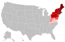 The Northeast United States as defined by the United States Census Bureau is highlighted in the two darker shades of red.[1] States in lighter shades of red and pink are defined as northeastern commonly by other sources. | |
| Subregions | |
| Country | |
| States | |
| Federal districts | |
| Population | |
| • Total | 55,982,803 |
| Demonym(s) | Northerner, Yankee |
The Census Bureau–defined region has a total area of 181,324 sq mi (469,630 km2) with 162,257 sq mi (420,240 km2) of that being land mass.[3] Although it lacks a unified cultural identity, the Northeastern region is the nation's most economically developed, densely populated, and culturally diverse region.[4][5] Of the nation's four census regions, the Northeast has the second-largest percentage of residents living in an urban setting, with 85 percent, and is home to the nation's largest metropolitan area.[6] The Northeast is home to most of the Northeast megalopolis, the most economically significant and second most-populated of eleven mega regions within the United States, accounting for 20% of US GDP.[7]
Composition
Geographically there is some debate as to where the Northeastern United States begins and ends. The vast area from central Virginia to northern Maine, and from western Pennsylvania (Pittsburgh) to the Atlantic Ocean, have all been loosely grouped into the Northeast at one time or another. Much of the debate has been what the cultural, economic and urban aspects of the Northeast are, and where they begin or end as one reaches the borders of the region.
Using the Census Bureau's definition of the Northeast, the region includes nine states: they are Maine, New York, New Jersey, Vermont, Massachusetts, Rhode Island, Connecticut, New Hampshire and Pennsylvania.[1][lower-alpha 1] The region is often subdivided into New England (the six states east of New York State) and the Mid-Atlantic states (New York, New Jersey and Pennsylvania). This definition has been essentially unchanged since 1880 and is widely used as a standard for data tabulation.[9][10][11][12] However, the Census Bureau has acknowledged the obvious limitations of this definition[13] and the potential merits of a proposal created after the 1950 census that would include changing regional boundaries to include Delaware, Maryland and the District of Columbia, with the Mid-Atlantic states, but ultimately decided that "the new system did not win enough overall acceptance among data users to warrant adoption as an official new set of general-purpose State groupings. The previous development of many series of statistics, arranged and issued over long periods of time on the basis of the existing State groupings, favored the retention of the summary units of the current regions and divisions."[14] The Census Bureau confirmed in 1994 that it would continue to "review the components of the regions and divisions to ensure that they continue to represent the most useful combinations of States and State equivalents."[14]
Many organizations and reference works follow the Census Bureau's definition for the region.[15][16][17] In the history of the United States, the Mason–Dixon line between Pennsylvania (the North) and Maryland (the South) traditionally divided the regions.[18] In modern times, various entities define the Northeastern United States in somewhat different ways. The Association of American Geographers divides the Northeast into two divisions: "New England", which is the same as the Census Bureau; and it has the same "Middle States" but adds Delaware.[19] Similarly, the Geological Society of America defines the Northeast as these same states but with the addition of Maryland and the District of Columbia.[20] The narrowest definitions include only the states of New England.[21] Other more restrictive definitions include New England and New York as part of the Northeast United States, but exclude Pennsylvania and New Jersey.[22][23]
| City | City Population | Metro Population | U.S. Rank |
|---|---|---|---|
| New York | 8,398,748 | 19,979,477 | 1 |
| Philadelphia | 1,584,138 | 6,096,120 | 6 |
| Washington | 705,749 | 6,216,589 | 20 |
| Boston | 694,583 | 4,628,910 | 21 |
| Baltimore | 602,495 | 2,802,789 | 30 |
| Pittsburgh | 301,048 | 2,362,453 | 66 |
States beyond the Census Bureau definition are included in Northeast Region by various other entities:
- Various organizations include: Delaware, Maryland and District of Columbia.[5][24][25][26][27][28]
- The US EPA and NOAA include in their Northeast Region: Delaware, Maryland and West Virginia.[29][30][31]
- The National Fish and Wildlife Service includes in their Northeast Region: Delaware, Maryland, District of Columbia, West Virginia, and Virginia.[32]
- The National Park Service includes in their Northeast Region: Delaware, Maryland, West Virginia, and Virginia (though small parts are also in the National Capital Region).[33]
History
Indigenous peoples
Anthropologists recognize the "Northeastern Woodlands" as one of the cultural regions that existed in the Western Hemisphere at the time of European colonists in the 15th and later centuries. Most did not settle in North America until the 17th century. The cultural area, known as the "Northeastern Woodlands", in addition to covering the entire Northeast U.S., also covered much of what is now Canada and others regions of what is now the eastern United States.[34] Among the many tribes that inhabited this area were those that made up the Iroquois nations and the numerous Algonquian peoples.[35] In the United States of the 21st century, 18 federally recognized tribes reside in the Northeast.[36] For the most part, the people of the Northeastern Woodlands, on whose lands European fishermen began camping to dry their codfish in the early 1600s, lived in villages, especially after being influenced by the agricultural traditions of the Ohio and Mississippi valley societies.[37]
Colonial history
All of the states making up the Northeastern region were among the original Thirteen Colonies, though Maine, Vermont, and Delaware were part of other colonies before the United States became independent in the American Revolution. The two cultural and geographic regions that form parts of the Northeastern region have distinct histories.
New England
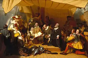
The first Europeans to settle New England were Pilgrims from England, who landed in present-day Massachusetts in 1620.[38] The Pilgrims arrived on the ship Mayflower and founded Plymouth Colony so they could practice religion freely.[38] Ten years later, a larger group of Puritans settled north of Plymouth Colony in Boston to form Massachusetts Bay Colony.[39] In 1636, colonists established Connecticut Colony and Providence Plantations.[40][41] Providence was founded by Roger Williams, who was banished by Massachusetts for his beliefs in freedom of religion, and it was the first colony to guarantee all citizens freedom of worship.[41] Anne Hutchinson, who was also banished by Massachusetts, formed the town of Portsmouth.[41] Providence, Portsmouth and two other towns (Newport and Warwick) consolidated to form the Colony of Rhode Island and Providence Plantations.[41]
Although the first settlers of New England were motivated by religion, in more recent history, New England has become one of the least religious parts of the United States. In a 2009 Gallup survey, less than half of residents in Vermont, New Hampshire, Maine and Massachusetts reported religion as an important part of their daily life.[42] In a 2010 Gallup survey, less than 30% of residents in Vermont, New Hampshire, Maine, and Massachusetts reported attending church weekly, giving them the lowest church attendance among U.S. states.[43]
New England played a prominent role in early American education. Starting in the 17th century, the larger towns in New England opened grammar schools, the forerunner of the modern high school. The first public school in the English colonies was the Boston Latin School, founded in 1635.[44] In 1636, the colonial legislature of Massachusetts founded Harvard College, the oldest institution of higher learning in the United States.[45]
Mid-Atlantic
The first European explorer known to have explored the Atlantic shoreline of the Northeast since the Norse was Giovanni da Verrazzano in 1524. His ship La Dauphine explored the coast from what is now known as Florida to New Brunswick. Henry Hudson explored the area of present-day New York in 1609 and claimed it for the Netherlands. His journey stimulated Dutch interest, and the area became known as New Netherland. In 1625, the city of New Amsterdam (the location of present-day New York City) was designated the capital of the province.[46] The Dutch New Netherland settlement along the Hudson River and, for a time, the New Sweden settlement along the Delaware River divided the English settlements in the north and the south. In 1664, Charles II of England formally annexed New Netherland and incorporated it into the English colonial empire.[47] The territory became the colonies of New York and New Jersey.[47] New Jersey was originally split into East Jersey and West Jersey until the two were united as a royal colony in 1702.[47]
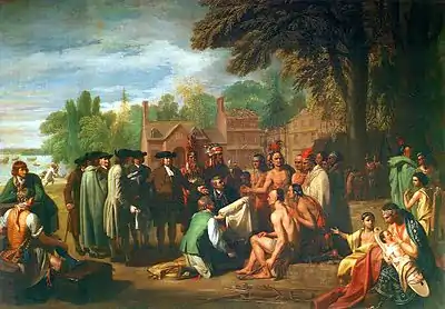
In 1681, William Penn, who wanted to give Quakers a land of religious freedom, founded Pennsylvania and extended freedom of religion to all citizens.[48]
Penn strongly desired access to the sea for his Pennsylvania Province and leased what then came to be known as the "Lower Counties on the Delaware"[49] from the Duke.
Penn established representative government and briefly combined his two possessions under one General Assembly in 1682. However, by 1704 the Province of Pennsylvania had grown so large that their representatives wanted to make decisions without the assent of the Lower Counties and the two groups of representatives began meeting on their own, one at Philadelphia, and the other at New Castle. Penn and his heirs remained proprietors of both and always appointed the same person Governor for their Province of Pennsylvania and their territory of the Lower Counties. The fact that Delaware and Pennsylvania shared the same governor was not unique. From 1703 to 1738, New York and New Jersey shared a governor.[50] Massachusetts and New Hampshire also shared a governor for some time.[51]
Environment


Topography
While most of the Northeastern United States lie in the Appalachian Highlands physiographic region, some are also part of the Atlantic coastal plain which extends south to the southern tip of Florida. The coastal plain areas (including Cape Cod in Massachusetts, Long Island in New York, most of New Jersey, Delaware and the Chesapeake Bay in Maryland and Virginia) are generally low and flat, with sandy soil and marshy land.[5] The highlands, including the Piedmont and the Appalachian Mountains, are generally heavily forested, ranging from rolling hills to summits greater than 6,000 feet (1,800 m), and pocked with many lakes.[5] The highest peak in the Northeast is Mount Washington (New Hampshire), at 6,288 feet (1,917 m).[52]
Land use
As of 2007, forest-use covered approximately 60% of the Northeastern states (including Delaware, Maryland and the District of Columbia), about twice the national average. About 12% was cropland and another 4% grassland pasture or range. There is also more urbanized land in the Northeast (11%) than any other region in the U.S.[28]
Climate
The climate of the Northeastern United States varies from northernmost Maine to southernmost Maryland. The climate of the region is created by the position of the general west to east flow of weather in the middle latitudes that much of the USA is controlled by and the position and movement of the subtropical highs. Summers are normally warm in northern areas to hot in southern areas. In summer, the building Bermuda High pumps warm and sultry air toward the Northeast, and frequent (but brief) thundershowers are common on hot summer days. In winter the subtropical high retreats southeastward, and the polar jet stream moves south bringing colder air masses from up in Canada and more frequent storm systems to the region. Winter often brings both rain and snow as well as surges of both warm and cold air.[53]
The basic climate of the Northeast can be divided into a colder and snowier interior (Pennsylvania, New York State and New England), and a milder coast and coastal plain from southern Rhode Island southward, including, New Haven, New York, Philadelphia, Trenton, Wilmington and Baltimore. Annual mean temperatures range from the low 50s F from Maryland to southern Connecticut, to the 40s F in most of New York State, New England and northern Pennsylvania.[53][54][55]
Wildlife
The Northeast has 72 National Wildlife Refuges, encompassing more than 500,000 acres (780 sq mi; 2,000 km2) of habitat and designed to protect some of the 92 different threatened and endangered species living in the region.[36]
Demographics


As of the July 2019 US Census Bureau estimate, the population of the region totaled 55,982,803.[56] With an average of 345.5 people per square mile, the Northeast is 2.5 times as densely populated as the second-most dense region, the South. Since the last century, the U.S. population has been shifting away from the Northeast (and Midwest) toward the South and West.[57]
The two U.S. Census Bureau divisions in the Northeast (New England and Mid-Atlantic) rank #2 and #1 among the 9 divisions in population density according to the 2013 population estimate. The South Atlantic region (233.1) was very close behind New England (233.2). Due to the faster growth of the South Atlantic region, it will take over the #2 division rank in population density in the next estimate, dropping New England to 3rd position. New England is projected to retain the number 3 rank for many, many years, as the only other lower-ranked division with even half the population density of New England is the East North Central division (192.1) and this region's population is projected to grow slowly. [lower-alpha 2][58]
| State | 2017 Estimate | 2010 Census | Change | Area | Density |
|---|---|---|---|---|---|
| Connecticut | 3,588,184 | 3,574,097 | +0.39% | 4,842.35 sq mi (12,541.6 km2) | 741/sq mi (286/km2) |
| Maine | 1,335,907 | 1,328,361 | +0.57% | 30,842.90 sq mi (79,882.7 km2) | 43/sq mi (17/km2) |
| Massachusetts | 6,859,819 | 6,547,629 | +4.77% | 7,800.05 sq mi (20,202.0 km2) | 879/sq mi (340/km2) |
| New Hampshire | 1,342,795 | 1,316,470 | +2.00% | 8,952.64 sq mi (23,187.2 km2) | 150/sq mi (58/km2) |
| Rhode Island | 1,059,639 | 1,052,567 | +0.67% | 1,033.81 sq mi (2,677.6 km2) | 1,025/sq mi (396/km2) |
| Vermont | 623,657 | 625,741 | −0.33% | 9,216.65 sq mi (23,871.0 km2) | 68/sq mi (26/km2) |
| New England | 14,810,001 | 14,444,865 | +2.53% | 62,688.4 sq mi (162,362 km2) | 236/sq mi (91/km2) |
| New Jersey | 9,005,644 | 8,791,894 | +2.43% | 7,354.21 sq mi (19,047.3 km2) | 1,225/sq mi (473/km2) |
| New York | 19,849,399 | 19,378,102 | +2.43% | 47,126.36 sq mi (122,056.7 km2) | 421/sq mi (163/km2) |
| Pennsylvania | 12,805,537 | 12,702,379 | +0.81% | 44,742.67 sq mi (115,883.0 km2) | 286/sq mi (111/km2) |
| Middle Atlantic | 41,660,580 | 40,872,375 | +1.93% | 99,223.24 sq mi (256,987.0 km2) | 420/sq mi (162/km2) |
| Total | 56,470,581 | 55,317,240 | +2.08% | 161,911.64 sq mi (419,349.2 km2) | 349/sq mi (135/km2) |
| Delaware | 961,939 | 897,936 | +7.13% | 1,948.54 sq mi (5,046.7 km2) | 494/sq mi (191/km2) |
| Maryland | 6,052,177 | 5,773,785 | +4.82% | 9,707.24 sq mi (25,141.6 km2) | 623/sq mi (241/km2) |
| District of Columbia | 693,972 | 601,767 | +15.32% | 61.05 sq mi (158.1 km2) | 11,367/sq mi (4,389/km2) |
| Total (Census + DE/MD/DC) | 64,178,669 | 62,590,728 | +2.54% | 173,628.47 sq mi (449,695.7 km2) | 370/sq mi (143/km2) |
Economy
As of 2012, the Northeast accounts for approximately 23% of U.S. gross domestic product.[59]
The Nuclear Regulatory Commission oversees 34 nuclear reactors, eight for research or testing and 26 for power production in the Northeastern United States.[27]
New York, considered a global financial center, is in the Northeast.
The Federal Bureau of Prisons maintains 17 federal prisons and two affiliated private facilities in the region.
Transportation
The following table includes all eight airports categorized by the FAA as large hubs[60] located in the Northeastern states[61] (New England and Eastern regions[62]):
| Rank | Metro area served | Airport code | Airport name | Largest airline[63] |
|---|---|---|---|---|
| 1 | New York | JFK | John F. Kennedy International Airport | JetBlue (37%) |
| 2 | New York | EWR | Newark Liberty International Airport | United (49%) |
| 3 | Philadelphia | PHL | Philadelphia International Airport | American (80%) |
| 4 | Boston | BOS | General Edward Lawrence Logan International Airport | JetBlue (29%) |
| 5 | New York | LGA | LaGuardia Airport | Delta (21%) |
| 6 | Baltimore/Washington | BWI | Baltimore-Washington International Thurgood Marshall Airport | Southwest (65%) |
| 7 | Washington | IAD | Dulles International Airport | United (41%) |
| 8 | Washington | DCA | Ronald Reagan National Airport | American (50%) |
Culture
One geographer, Wilbur Zelinsky, asserts that the Northeast region lacks a unified cultural identity,[4] but has served as a "culture hearth" for the rest of the nation.[64] Several much smaller geographical regions within the Northeast have distinct cultural identities.[4]
Landmarks
Almost half of the National Historic Landmarks maintained by the National Park Service are located in the Northeastern United States.[65]
Religion
According to a 2009 Gallup poll, the Northeastern states differ from most of the rest of the U.S. in religious affiliation, generally reflecting the descendants of immigration patterns of the late 19th and early 20th centuries, with many Catholics arriving from Ireland, Italy, French Canada - Quebec, Portugal and east-central Europe. Massachusetts, Rhode Island, New York and New Jersey are the only states in the nation where Catholics outnumber Protestants and other Christian denominations. More than 20% of respondents in Maine, New Hampshire, and Vermont declared no religious identity.[66] Compared to other U.S. regions, the Northeast, along with the Pacific Northwest, has the lowest regular religious service attendance and the fewest people for whom religion is an important part of their daily lives.[67]
Sports
The Northeast region is home to numerous professional sports franchises in the "Big Four" leagues (NFL, NBA, NHL and MLB),[68] with more than 100 championships collectively among them.[69]
- New York metropolitan area: Giants, Jets (NFL), Yankees, Mets (MLB), Knicks, Nets (NBA), Rangers, Islanders, Devils (NHL)
- Philadelphia: Eagles (NFL), Phillies (MLB), 76ers (NBA), Flyers (NHL)
- Boston: Patriots (NFL), Red Sox (MLB), Celtics (NBA), Bruins (NHL)
- Pittsburgh: Steelers (NFL), Pirates (MLB), Penguins (NHL)
- Buffalo: Bills (NFL), Sabres (NHL)
Major League Soccer features five Northeastern teams: D.C. United, New England Revolution, New York City FC, New York Red Bulls and Philadelphia Union. The region also has three WNBA teams: Connecticut Sun, New York Liberty and Washington Mystics.
Notable golf tournaments in the Northeastern United States include the Deutsche Bank Championship, The Barclays, Quicken Loans National and Atlantic City LPGA Classic. The US Open, held in New York, is one of the four Grand Slam tennis tournaments, whereas the Washington Open is part of the ATP World Tour 500 series.
Notable Northeastern motorsports tracks include Watkins Glen International, Dover International Speedway, Pocono Raceway, New Hampshire Motor Speedway and Lime Rock Park, which have hosted Formula One, IndyCar, NASCAR and International Motor Sports Association races. Also, drag strips such as Englishtown, Epping and Reading have hosted NHRA national events. Pimlico Race Course at Baltimore and Belmont Park at New York host the Preakness Stakes and Belmont Stakes horse races, which are part of the Triple Crown of Thoroughbred Racing.
The region has also been noted for the prevalence of the traditionally Northeastern sports of ice hockey and lacrosse.[70]
Health
The rate of potentially preventable hospitalizations in the Northeastern United States fell from 2005 to 2011 for overall conditions, acute conditions, and chronic conditions.[71]
Politics
The Northeastern United States tended to vote Republican in federal elections through the first half of the 20th century, but the region has since the 1990s shifted to become the most Democratic in the nation.[26] Results from a 2008 Gallup poll indicated that eight of the top ten Democratic states were located in the region, with every Northeastern state having a Democratic party affiliation advantage of at least ten points.[72] The following table demonstrates Democratic support in the Northeast as compared to the remainder of the nation.[73]
| Year | % President vote | % Senate seats | % House seats | |||
|---|---|---|---|---|---|---|
| Northeast | Remainder | Northeast | Remainder | Northeast | Remainder | |
| 2000 | 57.6 | 47.5 | 60.0 | 46.3 | 59.6 | 45.7 |
| 2002 | 60.0 | 45.0 | 58.3 | 44.7 | ||
| 2004 | 57.1 | 47.3 | 60.0 | 40.0 | 59.5 | 43.0 |
| 2006 | 75.0 | 45.0 | 73.8 | 48.3 | ||
| 2008 | 60.7 | 52.0 | 80.0 | 52.5 | 81.0 | 52.9 |
| 2010 | 75.0 | 47.5 | 67.9 | 38.5 | ||
The following table of United States presidential election results since 1920 illustrates that over the past seven presidential elections, only three Northeastern states supported a Republican candidate (New Hampshire voted for George W. Bush in 2000; Pennsylvania and Maine's 2nd congressional district voted for Donald Trump in 2016).[74] 2004 is so far the only election in U.S. history in which the winner did not win any northeastern state. Bolded entries indicate that party's candidate also won the general election.
| State | 1920 | 1924 | 1928 | 1932 | 1936 | 1940 | 1944 | 1948 | 1952 | 1956 | 1960 | 1964 | 1968 | 1972 | 1976 | 1980 | 1984 | 1988 | 1992 | 1996 | 2000 | 2004 | 2008 | 2012 | 2016 | 2020 |
|---|---|---|---|---|---|---|---|---|---|---|---|---|---|---|---|---|---|---|---|---|---|---|---|---|---|---|
| CT | R | R | R | R | D | D | D | R | R | R | D | D | D | R | R | R | R | R | D | D | D | D | D | D | D | D |
| DE | R | R | R | R | D | D | D | R | R | R | D | D | R | R | D | R | R | R | D | D | D | D | D | D | D | D |
| DC | D | D | D | D | D | D | D | D | D | D | D | D | D | D | D | |||||||||||
| ME | R | R | R | R | R | R | R | R | R | R | R | D | D | R | R | R | R | R | D | D | D | D | D | D | D (R ME-02) |
D (R ME-02) |
| MD | R | R | R | D | D | D | D | R | R | R | D | D | D | R | D | D | R | R | D | D | D | D | D | D | D | D |
| MA | R | R | D | D | D | D | D | D | R | R | D | D | D | D | D | R | R | D | D | D | D | D | D | D | D | D |
| NH | R | R | R | R | D | D | D | R | R | R | R | D | R | R | R | R | R | R | D | D | R | D | D | D | D | D |
| NJ | R | R | R | D | D | D | D | R | R | R | D | D | R | R | R | R | R | R | D | D | D | D | D | D | D | D |
| NY | R | R | R | D | D | D | D | R | R | R | D | D | D | R | D | R | R | D | D | D | D | D | D | D | D | D |
| PA | R | R | R | R | D | D | D | R | R | R | D | D | D | R | D | R | R | R | D | D | D | D | D | D | R | D |
| RI | R | R | D | D | D | D | D | D | R | R | D | D | D | R | D | D | R | D | D | D | D | D | D | D | D | D |
| VT | R | R | R | R | R | R | R | R | R | R | R | D | R | R | R | R | R | R | D | D | D | D | D | D | D | D |
The following table shows the breakdown of party affiliation of governors, attorneys general, state legislative houses and U.S. congressional delegation for the Northeastern states, as of May 2020. (Demographics reflect registration-by-party figures from that state's registered voter statistics.)
| State | Governor | Attorney General | Upper House Majority | Lower House Majority | Senior U.S. Senator | Junior U.S. Senator | U.S. House Delegation | Demographics |
|---|---|---|---|---|---|---|---|---|
| CT | Democratic | Democratic | Democratic 23-13 |
Democratic 92-59 |
Democratic | Democratic | Democratic 5-0 |
Democratic 36-21 |
| DE | Democratic | Democratic | Democratic 12-9 |
Democratic 26-15 |
Democratic | Democratic | Democratic 1-0 |
Democratic 48-28 |
| ME | Democratic | Democratic | Democratic 21-14 |
Democratic 89-57-5 |
Republican | Independent | Democratic 2-0 |
Democratic 32-27 |
| MD | Republican | Democratic | Democratic 32-15 |
Democratic 99-42 |
Democratic | Democratic | Democratic 7-1 |
Democratic 55-26 |
| MA | Republican | Democratic | Democratic 34-6 |
Democratic 127-32 |
Democratic | Democratic | Democratic 9-0 |
Democratic 35-11 |
| NH | Republican | Republican | Republican 14-10 |
Republican 213-187 |
Democratic | Democratic | Democratic 2-0 |
Republican 30-27 |
| NJ | Democratic | Democratic | Democratic 24-16 |
Democratic 52-28 |
Democratic | Democratic | Democratic 10-2 |
Democratic 32-21 |
| NY | Democratic | Democratic | Democratic 40-23 |
Democratic 106-43-1 |
Democratic | Democratic | Democratic 23-6 |
Democratic 49-24 |
| PA | Democratic | Democratic | Republican 29-21 |
Republican 110-93 |
Democratic | Republican | Tied 9-9 |
Democratic 50-37 |
| RI | Democratic | Democratic | Democratic 33-5 |
Democratic 66-9 |
Democratic | Democratic | Democratic 2-0 |
Democratic 42-11 |
| VT | Republican | Democratic | Democratic 22-6-2 |
Democratic 95-43-7-5 |
Democratic | Independent | Democratic 1-0 |
Democratic 47-31 |
Notes
- The U.S. Census Bureau reorganized its administrative units, and its regional offices do not cover the Census regions (the northeasternmost regional office headquartered in New York covers New England, New York, New Jersey and Puerto Rico).[8]
- Based on U.S. Census Bureau population projections to 2030 (and assuming constant land area) the population density for the South Atlantic division will increase significantly to 294.6/mi2, New England's density will increase to 249.2/mi2 and the East North Central division will increase only slightly to 200.2/mi2. The division with the 5th highest density is projected to be the East South Central division at 111.6/mi2.[58]
References
- "Census Regions and Divisions of the United States" (PDF). United States Department of Commerce, Economics and Statistics Administration, United States Census Bureau, Geography Division. Archived from the original (PDF) on September 21, 2013.
- "2019 U.S. Population Estimates Continue to Show the Nation's Growth Is Slowing". United States Census Bureau, Population Division. December 30, 2019. Retrieved May 24, 2020.
The Northeast region, the smallest of the four regions with a population of 55,982,803 in 2019, saw population decrease for the first time this decade, declining by 63,817 or -0.1%.
- "American FactFinder, GCT-PH1-Population, Housing Units, Area, and Density". U.S. Census Bureau. 2000. Archived from the original on February 12, 2020.
- Zelinsky, Wilbur (June 1980). "North America's Vernacular Regions". Annals of the Association of American Geographers. 70 (1): 1–16. doi:10.1111/j.1467-8306.1980.tb01293.x.
- Hobbs, Joseph John (2009). World Regional Geography. Cengage Learning. p. 647. ISBN 9780495389507. Retrieved November 4, 2013.
- Elkins, Rick (March 28, 2012). "Census Bureau releases list of urban areas". Porterville Recorder. Archived from the original on July 26, 2013. Retrieved July 25, 2012.
- "Northeast". Regional Plan Association. 2019.
- "2013 Regions of the US Census Bureau" (PDF). Census Bureau. Retrieved July 22, 2013.
- Geographic Areas Reference Manual. U.S. Census Bureau. 1994. pp. 6–1. Retrieved July 4, 2013.
- Seymour Sudman & Norman M. Bradburn (1982). Asking Questions: Practical Guide to Questionnaire Design. Jossey-Bass. p. 205. ISBN 9780875895468.
The most widely used regional definitions follow those of the U.S. Bureau of the Census.
- Dale M. Lewison (1997). Retailing. Prentice Hall. p. 384. ISBN 978-0-13-461427-4.
Perhaps the most widely used regional classification system is one developed by the U.S. Census Bureau.
- Pamela Goyan Kittler; Kathryn P. Sucher (2008). Food and Culture. Cengage Learning. p. 475. ISBN 9780495115410.
(M)ost demographic and food consumption data are presented in this four-region format.
- Proceedings of the National Geographic Areas Conference: putting it together for 1990. U.S. Census Bureau. 1984. p. 161.
- "Six: Statistical Groupings of States and Counties". Geographic Areas Reference Manual (PDF). U.S. Census Bureau. November 1994. Retrieved July 31, 2013.
- Verne Thompson, ed. (2010). Encyclopedia of Associations: Regional, State, and Local Organizations: Northeastern States. (Vol. 2: Northeastern States) (22 ed.). Gale.
- The New York Times Guide to Essential Knowledge: A Desk Reference for the Curious Mind. Macmillan. 2011. p. 630. ISBN 9781429950855.
- Kelley, Mary Lebreck & Virginia Macken Fitzsimons (2000). Understanding Cultural Diversity: Culture, Curriculum, and Community in Nursing. Jones & Bartlett Learning. p. 220. ISBN 9780763711061.
- "Mason-Dixon Line". Encyclopedia Britannica.
- "Overview – AAG". aag.org.
- "Geological Society of America – Northeastern Section". geosociety.org.
- "NROC Overview". Northeast Regional Ocean Council. Retrieved July 11, 2013.
- "Safety: ORA District and Headquarters Recall Coordinators". U.S. Food and Drug Administration. Retrieved July 24, 2013.
- "About The Council". Department of Defense Northeast Regional Council. Retrieved September 21, 2013.
- John C. Hudson (2002). Across This Land: A Regional Geography of the United States and Canada. p. 81 ff. ISBN 0801865670.
- Thomas F. McIlwraith; Edward K. Muller (2001). North America: The Historical Geography of a Changing Continent. p. 190. ISBN 0742500195.
- Shelley, Fred M., ed. (1996). Political Geography of the United States. Guilford Press. ISBN 1572300485.
- "Region I Jurisdiction". Nuclear Regulatory Commission. Retrieved July 25, 2013.
- Cynthia Nickerson; Robert Ebel; Allison Borchers & Fernando Carriazo (2007). "Major Uses of Land in the United States". USDA's Economic Research Service. Archived from the original on July 30, 2013.
- Barron, Eric (2001). "Chapter 4: Potential Consequences of Climate Variability and Change for the Northeastern United States". In National Assessment Synthesis Team, U.S. Global Change Research Program (ed.). Climate Change Impacts on the United States: The Potential Consequences of Climate Variability and Change. Cambridge University Press. ISBN 0-521-00075-0. Retrieved March 15, 2010.
- "Northeast Climate Region". United States Environmental Protection Agency.
- "Northeast Regional Climate Center". National Oceanic and Atmospheric Administration.
- "Northeast Region". United States Fish and Wildlife Service.
- "National Park Service Regions" (PDF). United States Department of the Interior.
- Mir Tamim Ansary (2001). Eastern Woodlands Indians. Capstone Classroom. p. 4. ISBN 9781588104519.
- Pritzker, Barry (2000). A Native American Encyclopedia: History, Culture, and Peoples. Oxford University Press. p. 398. ISBN 0195138775.
- "Northeast Region Fact Sheet" (PDF).
- Nash, Gary B. Red, White and Black: The Peoples of Early North America Los Angeles 2015. Chapter 1, p. 8
- Arenstam, Peter; Kemp, John; Grace, Catherine O'Neill (2007). Mayflower 1620: A New Look at a Pilgrim Voyage. Washington, D.C.: National Geographic. ISBN 9780792262763.
- "A Brief History of Cambridge, Massachusetts, USA". Cambridge Historical Commission. Archived from the original on September 30, 2012. Retrieved August 16, 2012.
- Kelly, Martin. "Connecticut Colony". About.com. Retrieved August 16, 2012.
- Kelly, Martin. "Rhode Island Colony". About.com. Retrieved August 16, 2012.
- Newport, Frank. "State of the States: Importance of Religion". Gallup. Retrieved August 17, 2012.
- "Mississippians Go to Church the Most; Vermonters, Least". Gallup.com. Retrieved March 17, 2012.
- Jenks, Henry Fitch (1880). The Boston Public Latin School. 1635-1880. M. King. Retrieved August 16, 2012.
- "Harvard University Founded". CelebrateBoston.com. Retrieved August 16, 2012.
- Barreveld, Drs. Dirk J. (2001). From New Amsterdam to New York : the founding of New York by the Dutch in July 1625. New York: Writers Club Press. ISBN 9780595198900.
- "The Middle Colonies". Radford University. Retrieved August 16, 2012.
- Forrest, Tuomi J. "William Penn – Introduction". Archived from the original on December 8, 2013. Retrieved August 16, 2012.
- Munroe, John A (2006). "3. The Lower Counties on The Delaware". History of Delaware (5th, illustrated ed.). University of Delaware Press. p. 45. ISBN 0-87413-947-3.
- Lurie, Mappen M (2004), Encyclopedia of New Jersey, Rutgers University Press, p. 327, ISBN 0-8135-3325-2.
- Mayo, LS (1921), John Wentworth, Governor of New Hampshire: 1767–1775, Harvard University Press, p. 5.
- "Mount Washington". NGS data sheet. U.S. National Geodetic Survey.
- "Regional Climate Trends and Scenarios for the U.S. National Climate Assessment" (PDF). National Oceanic and Atmospheric Administration. January 2013.
- "Climate Summaries - Northeast Overview - January 2013".
- "Climate Summaries - Northeast Overview - July 2012".
- "2019 U.S. Population Estimates Continue to Show the Nation's Growth Is Slowing". United States Census Bureau, Population Division. December 30, 2019. Retrieved May 11, 2020.
The Northeast region, the smallest of the four regions with a population of 55,982,803 in 2019, saw population decrease for the first time this decade, declining by 63,817 or -0.1%.
- Frank Hobbs & Nicole Stoops (2002). Demographic Trends in the 20th Century. p. 18. ISBN 9780160676338. Retrieved July 12, 2013.
- "2005 Interim State Population Projections - People and Households - U.S. Census Bureau". census.gov.
- "Gross Domestic Product (GDP) by State".
- Calendar Year 2011 Primary Airports
- "ATCSCC Flight Delay Information – Northeastern States". faa.gov.
- "Airports Regional & District/Development Offices". faa.gov.
- "RITA – BTS – Transtats". bts.gov.
- Zelinsky, Wilbur (December 1955). "Some Problems in the Distribution of Generic Terms in the Place-Names of the Northeastern United States". Annals of the Association of American Geographers. 45 (4): 319. doi:10.1111/j.1467-8306.1955.tb01491.x.
- "Northeast Region – History & Culture".
- "Religious Identity: States Differ Widely".
- Twenge, Jean M. (2015). "Generational and Time Period Differences in American Adolescents' Religious Orientation, 1966–2014". PLOS ONE. 10 (5): e0121454. doi:10.1371/journal.pone.0121454. PMC 4427319. PMID 25962174. Retrieved October 6, 2015.
- "All Cities Are Not Created Equal".
- "The Northeast Region".
- Kirsch, George B.; Othello Harris; Claire Elaine Nolte, eds. (2000). Encyclopedia of Ethnicity and Sports in the United States. Greenwood Publishing Group. ISBN 0313299110.
- Torio CM, Andrews RM (September 2014). "Geographic Variation in Potentially Preventable Hospitalizations for Acute and Chronic Conditions, 2005-2011". HCUP Statistical Brief #178. Rockville, Maryland: Agency for Healthcare Research and Quality.
- "State of the States: Political Party Affiliation".
- Reiter, Howard L. & Jeffrey M. Stonecash (2011). Counter Realignment: Political Change in the Northeastern United States. Cambridge University Press. ISBN 978-1139493130.
- "Historical Election Results". U.S. National Archives and Records Administration.
| Wikivoyage has a travel guide for Northeastern United States. |