2021 Pacific typhoon season
The 2021 Pacific typhoon season is an ongoing event in the annual cycle of tropical cyclone formation, in which tropical cyclones form in the western Pacific Ocean. The season runs throughout 2021, with no seasonal boundaries, though most tropical cyclones typically develop between May and October. The scope of this article is limited to the Pacific Ocean to the north of the equator between 100°E and 180th meridian. Within the northwestern Pacific Ocean, there are two separate agencies that assign names to tropical cyclones, which can often result in a cyclone having two names. The Japan Meteorological Agency (JMA) names a tropical cyclone should it be judged to have 10-minute sustained wind speeds of at least 65 km/h (40 mph) anywhere in the basin, whilst the Philippine Atmospheric, Geophysical and Astronomical Services Administration (PAGASA) assigns names to tropical cyclones which move into or form as a tropical depression in their area of responsibility located between 135°E and 115°E and between 5°N and 25°N, regardless of whether or not a tropical cyclone has already been given a name by the JMA. Tropical depressions that are monitored by the United States' Joint Typhoon Warning Center (JTWC) are given a number with a "W" suffix.
| 2021 Pacific typhoon season | |
|---|---|
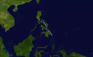 Season summary map | |
| Seasonal boundaries | |
| First system formed | January 19, 2021 |
| Last system dissipated | Season ongoing |
| Strongest storm | |
| Name | TD |
| • Lowest pressure | 1008 hPa (mbar) |
| Seasonal statistics | |
| Total depressions | 1 |
| Total fatalities | 1 total |
| Total damage | $10.8 million (2021 USD) |
| Related articles | |
Seasonal forecasts
| Other forecasts Date | Forecast Center | Period | Systems | Ref. | |
|---|---|---|---|---|---|
| December 27, 2020 | PAGASA | January–March | 0–3 tropical cyclones | [1] | |
| December 27, 2020 | PAGASA | April–June | 1–4 tropical cyclones | [1] | |
| 2021 season | Forecast Center | Tropical cyclones | Tropical storms | Typhoons | Ref. |
| Actual activity: | JMA | 1 | 0 | 0 | |
| Actual activity: | JTWC | 0 | 0 | 0 | |
| Actual activity: | PAGASA | 0 | 0 | 0 | |
During the year several national meteorological services and scientific agencies forecast how many tropical cyclones, tropical storms, and typhoons will form during a season and/or how many tropical cyclones will affect a particular country. These agencies included the Tropical Storm Risk (TSR) Consortium of University College London, PAGASA and Taiwan's Central Weather Bureau. The first forecast was released by PAGASA on December 27, 2020, in their monthly seasonal climate outlook predicting the first half of 2021.[1] The PAGASA predicts that only 0–3 tropical cyclones are expected to form or enter the Philippine Area of Responsibility between January and March, while 1–4 tropical cyclones are expected to form between April and June. PAGASA also predicted that the ongoing La Niña could persist until the end of the first quarter of 2021.[1]
Seasonal summary

Systems
Tropical Depression
| Tropical depression (JMA) | |
 | |
| Duration | January 19 – January 20 |
|---|---|
| Peak intensity | <55 km/h (35 mph) (10-min) 1008 hPa (mbar) |
During January 19, the JMA reported that a tropical depression had developed to the east of Luzon, Philippines.[2] The precursor to the depression brought scattered showers and thunderstorms to Mindanao, Palawan, and Visayas on January 18.[3] The JMA, however, discontinued advisories for the system on the next day.[4]
The depression also brought stormy weather to Luzon on January 20. PAGASA warned residents of possible flash flooding and mudslides due to heavy rainfall.[5] The precursor of this system was associated from a frontal system, and its combined effects which brought heavy rainfall over much of Visayas, the Bicol Region, and Northern Mindanao resulted in one death and agricultural damages of up to ₱519.7 million (US$10.8 million).[6]
Storm names
Within the Northwest Pacific Ocean, both the Japan Meteorological Agency (JMA) and the Philippine Atmospheric, Geophysical and Astronomical Services Administration (PAGASA) assign names to tropical cyclones that develop in the Western Pacific, which can result in a tropical cyclone having two names.[7] The Japan Meteorological Agency's RSMC Tokyo — Typhoon Center assigns international names to tropical cyclones on behalf of the World Meteorological Organization's Typhoon Committee, should they be judged to have 10-minute sustained windspeeds of 65 km/h (40 mph).[8] PAGASA names to tropical cyclones which move into or form as a tropical depression in their area of responsibility located between 135°E and 115°E and between 5°N and 25°N even if the cyclone has had an international name assigned to it.[7] The names of significant tropical cyclones are retired, by both PAGASA and the Typhoon Committee.[8] Should the list of names for the Philippine region be exhausted then names will be taken from an auxiliary list of which the first ten are published each season. Unused names are marked in gray.
International names
A tropical cyclone is named when it is judged to have 10-minute sustained windspeeds of 65 km/h (40 mph).[9] The JMA selected the names from a list of 140 names, that had been developed by the 14 members nations and territories of the ESCAP/WMO Typhoon Committee.[10] Retired names, if any, will be announced by the WMO in 2022; though replacement names will be announced in 2023. The next 28 names on the naming list are listed here along with their international numeric designation, if they are used.
|
|
|
|
Philippines
This season, PAGASA will use its own naming scheme, that will either develop within or move into their self-defined area of responsibility.[11] The names were taken from a list of names, that was last used during 2017 and are scheduled to be used again during 2025.[11] All of the names are the same except Uwan and Verbena which replaced the names Urduja and Vinta after they were retired.[11]
|
|
|
|
|
Auxiliary list
|
|
|
|
|
Season effects
This table summarizes all the systems that developed within or moved into the North Pacific Ocean, to the west of the International Date Line during 2021. The tables also provide an overview of a systems intensity, duration, land areas affected and any deaths or damages associated with the system.
| Name | Dates active | Peak classification | Sustained wind speeds |
Pressure | Areas affected | Damage (USD) |
Deaths | Refs |
|---|---|---|---|---|---|---|---|---|
| TD | January 19 – 20 | Tropical depression | Not specified | 1008 hPa (29.77 inHg) | Philippines | $10.8 million | 1 | [6] |
| Season aggregates | ||||||||
| 1 system | January 19 – Season ongoing | <55 km/h (<35 mph) | 1008 hPa (29.77 inHg) | $10.8 million | 1 | |||
See also
- Tropical cyclones in 2021
- Pacific typhoon season
- List of wettest tropical cyclones
- 2021 Atlantic hurricane season
- 2021 Pacific hurricane season
- 2021 North Indian Ocean cyclone season
- South-West Indian Ocean cyclone seasons: 2020–21, 2021–22
- Australian region cyclone seasons: 2020–21, 2021–22
- South Pacific cyclone seasons: 2020–21, 2021–22
References
- 131st Climate Forum Climate Outlook January–June 2021 (PDF) (Seasonal Climate Outlook). Philippine Atmospheric Geophysical and Astronomical Services Administration. December 27, 2020. Retrieved December 27, 2020.
- "WWJP27 RJTD 191800". Japan Meteorological Agency. 19 January 2021. Archived from the original on 20 January 2021. Retrieved 20 January 2021.
- Cristina Arayata (January 18, 2021). "LPA, ITCZ to bring scattered rains Monday". pna.gov.ph. Philippine News Agency. Retrieved January 20, 2021.
- "Warning and Summary 201200". Japan Meteorological Agency. January 20, 2021. Archived from the original on January 20, 2021. Retrieved January 20, 2021.
- Acor Arceo (January 20, 2021). "Parts of Luzon rainy due to LPA off Aurora, tail-end of frontal system". rappler.com. Rappler. Retrieved January 21, 2021.
- "SitRep no.09 re Prep. Measures and Effects for TEFS in Reg V, VI, VIII and X" (PDF). NDRRMC. January 20, 2021.
- Padgett, Gary. "Monthly Tropical Cyclone Summary December 1999". Australian Severe Weather. Archived from the original on August 28, 2012. Retrieved October 1, 2013.
- The Typhoon Committee (February 21, 2013). "Typhoon Committee Operational Manual 2013". World Meteorological Organization. pp. 37–38. Archived from the original (PDF) on August 28, 2012. Retrieved October 1, 2013.
- http://www.typhooncommittee.org/48th/docs/item%204%20technical%20presentations/4.1.Review2015TyphoonSeason.pdf
- Zhou, Xiao; Lei, Xiaotu (2012). "Summary of retired typhoons within the Western North Pacific Ocean". Tropical Cyclone Research and Review. The Economic and Social Commission for Asia and the Pacific/World Meteorological Organization's Typhoon Committee. 1 (1): 23–32. doi:10.6057/2012TCRR01.03. ISSN 2225-6032. Retrieved December 21, 2014.
- "Philippine Tropical Cyclone Names". Philippine Atmospheric, Geophysical and Astronomical Services Administration. Archived from the original on January 30, 2021. Retrieved January 30, 2021.
External links
| Wikimedia Commons has media related to 2021 Pacific typhoon season. |
- China Meteorological Agency
- Digital Typhoon
- Hong Kong Observatory
- Japan Meteorological Agency
- Joint Typhoon Warning Center
- Korea Meteorological Administration
- Malaysian Meteorological Department
- National Weather Service Guam
- Philippine Atmospheric, Geophysical and Astronomical Services Administration
- Taiwan Central Weather Bureau
- TCWC Jakarta (in Indonesian)
- Thai Meteorological Department (in Thai)
- Typhoon2000
- Vietnam's National Hydro-Meteorological Service
Tropical cyclones of the 2021 Pacific typhoon season | ||||
|---|---|---|---|---|
Timeline | ||||
|
| |||
| ||||