2020–21 South-West Indian Ocean cyclone season
The 2020–21 South-West Indian Ocean cyclone season is an ongoing event of the highest amount of tropical cyclone and subtropical cyclone formation. The season started with the formation of Tropical Cyclone Alicia in the extreme northeast section of the basin on 12 November, just before the official start of the season, which marked the third season in a row in which a tropical cyclone formed before the beginning of the season. It officially began on 15 November 2020, and will officially end on 30 April 2021, with the exception for Mauritius and the Seychelles, for which it will officially end on 15 May 2021. These dates conventionally delimit the period of each year when most tropical and subtropical cyclones form in the basin, which is west of 90°E and south of the Equator. Tropical and subtropical cyclones in this basin are monitored by the Regional Specialised Meteorological Centre in Réunion and unofficially by the Joint Typhoon Warning Center.
| 2020–21 South-West Indian Ocean cyclone season | |
|---|---|
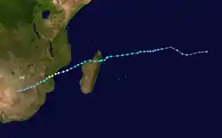
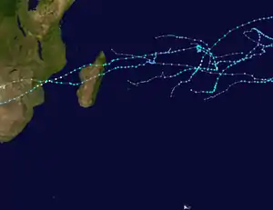 Season summary map | |
| Seasonal boundaries | |
| First system formed | 12 November 2020 |
| Last system dissipated | Season ongoing |
| Strongest storm | |
| Name | Eloise |
| • Maximum winds | 150 km/h (90 mph) (10-minute sustained) |
| • Lowest pressure | 967 hPa (mbar) |
| Seasonal statistics | |
| Total disturbances | 10 |
| Total depressions | 10 |
| Total storms | 7 |
| Tropical cyclones | 2 |
| Intense tropical cyclones | 0 |
| Very intense tropical cyclones | 0 |
| Total fatalities | 28 total |
| Total damage | Unknown |
| Related articles | |
Seasonal summary
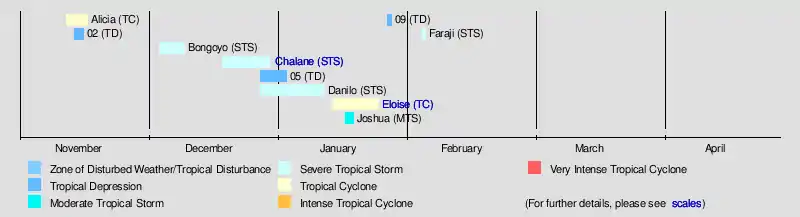
On 12 November, Alicia formed on the extreme northeast section of the basin. This marked the third season in a row with a pre-season tropical cyclone. Alicia strengthened into a tropical cyclone on 15 November, rapidly weakened due to the vertical wind shear and cool waters, and dissipated on 17 November. On 14 November, another tropical disturbance formed off the coast of Madagascar; however, on 16 November the system failed to organise due to unfavourable vertical wind shear according to JTWC. It rapidly weakened and dissipated the next day. The basin remained quiet until, on 30 November, a tropical low crossed over from the Australian region. It strengthened into a moderate tropical storm, then to a severe tropical storm, and was named Bongoyo. Two additional low formed, one formed but exited the basin on 20 December and another Zone of Disturbed Weather formed near Diego Garcia, which strengthened to Severe Tropical Storm Chalane, which made landfall on Madagascar and Mozambique, the first tropical cyclone for this season to make landfall. The same Zone of Disturbed Weather which exited on 20 December, again re-entered on 28 December, following with another Zone of Disturbed Weather, designated 06. On 1 January, 06 intensified into Tropical Storm Danilo. It became the second longest system and dissipated on 12 January. On 15 January, a new disturbance which became depression formed which later became Cyclone Eloise and made two landfalls over Madagascar and Mozambique with second landfall being more catastrophic and brought widespread damages over African nations killing 16 people. On 17 January, Joshua entered the South-West Indian Ocean as a moderate tropical storm; however, it dissipated on 19 January as it entered an area of dry air and high vertical wind shear. On 27 January, Tropical Low 10U entered from the Australian region where it was redesignated as Tropical Depression 09.
Systems
Tropical Cyclone Alicia
| Tropical cyclone (MFR) | |
| Category 1 tropical cyclone (SSHWS) | |
  | |
| Duration | 12 November – 17 November |
|---|---|
| Peak intensity | 120 km/h (75 mph) (10-min) 975 hPa (mbar) |
On 12 November, Météo-France La Réunion (MFR) also began tracking a tropical disturbance as it moved slowly westwards over the central Indian Ocean.[1] Later that day, the JTWC issued a Tropical Cyclone Formation Alert.[2] The disturbance consolidated slowly as thunderstorms wrapped around the center of circulation, and it became a tropical depression by 00:00 UTC on 13 November.[3] The depression continued to become more organized over the day with flaring convection over the center, and thus was upgraded to Moderate Tropical Storm Alicia at 18:00 UTC that same day.[4] On 14 November at 06:00 UTC, Alicia strengthened into a severe tropical storm.[5] Alicia generally moved in a southwesterly direction at a quick pace due to the steering flow of a mid-level subtropical ridge to the storm's southeast.[6] The severe tropical storm intensified into Tropical Cyclone Alicia at 00:00 UTC on 16 November, after very intense convection developed near its center.[7] Soon after Alicia entered a region with unfavorable conditions: high wind shear and cooler waters. Due to these conditions, Alicia began to rapidly weaken, degrading to a tropical storm at 12:00 UTC on 16 November.[8] At 09:00 UTC on 17 November, the Joint Typhoon Warning Center issued its final warning on the storm.[9]
Tropical Depression 02
| Tropical depression (MFR) | |
  | |
| Duration | 14 November – 17 November |
|---|---|
| Peak intensity | 55 km/h (35 mph) (10-min) 999 hPa (mbar) |
On 12 November, alongside the precursor of Tropical Cyclone Alicia, Météo-France La Réunion (MFR) began to monitor a monsoonal disturbance to its west for potential development into a tropical system.[10] By 14 November, an area of disturbed weather had formed but struggled to centralize its thunderstorm activity, despite a low level circulation beginning to form.[11] With improvements in further consolidation, the MFR initiated advisories for a tropical depression in the northeast of Madagascar at 18:00 UTC on 15 November.[12] The storm struggled to intensify much due to strong easterly shear from its close proximity to Tropical Cyclone Alicia's outflow, and thus had its thunderstorm activity sheared to its west for most of its lifetime.[13] Due to this, the JTWC cancelled the tropical cyclone formation alert on 16 November.[14] It rapidly weakened and the last advisory was issued by the MFR on 16 November as well.[15]
Severe Tropical Storm Bongoyo
| Severe tropical storm (MFR) | |
| Tropical storm (SSHWS) | |
  | |
| Duration | 4 December – 10 December |
|---|---|
| Peak intensity | 100 km/h (65 mph) (10-min) 988 hPa (mbar) |
During 30 November, Tropical Low 01U moved into the basin from the Australian region, where it was classified as a Zone of Disturbed Weather by RSMC La Reunion.[16] Early on 4 December, the JTWC issued a Tropical Cyclone Formation Alert on the system.[17] After meandering slowly to the west and northwest for several days with little change in strength, the system began to take a more southerly track and at 06:00 UTC on 6 December was upgraded to Tropical Disturbance 03 by MFR as the low level circulation became tighter and convection consolidated near the center.[18] On 7 December, the disturbance intensified into Moderate Tropical Storm Bongoyo as an ASCAT pass revealed gale-force winds on the southern half of the circulation.[19] At this time, the JTWC cited a favorable environment for further intensification as Bongoyo headed southwest.[20] While Bongoyo gained a distinct mid-level eye and as strong bursts of convection maintained near the center, the storm further strengthened to severe tropical storm status at 00:00 UTC on 8 December.[21]
However, Bongoyo's intensification trend was halted as the impacts of strengthening vertical wind shear caused the eyewall to become eroded later into the day.[22] Bongoyo maintained its strength, although the overall structure of the storm became increasingly vertically tilted.[23] On 18:00 UTC on 9 December, Bongoyo finally weakened back down to a moderate tropical storm after maintaining its strength for over a day while convection became further dislocated from the circulation.[24] Bongoyo soon began its westward turn on 10 December as it began to ride along the southern edge of a subtropical ridge, and it became a remnant low early on 11 December as all convection had became sheared away from the low level circulation, thus the last advisory was issued by both MFR and the JTWC.[25][26]
Severe Tropical Storm Chalane
| Severe tropical storm (MFR) | |
| Tropical storm (SSHWS) | |
  | |
| Duration | 19 December – 30 December |
|---|---|
| Peak intensity | 110 km/h (70 mph) (10-min) 983 hPa (mbar) |
On 19 December, RSMC La Réunion began monitoring a zone of disturbed weather situated approximately 830 km (515 mi) southwest of Diego Garcia.[27] The system was located in a favourable environment for intensification due to the presence of a Kelvin wave and an equatorial Rossby wave, as well as warm sea surface temperatures, low to moderate vertical wind shear and good upper-level outflow.[28] Conditions began to somewhat deteriorate over the next several days as the system meandered to the west, however the storm managed to reach tropical depression status on 23 December, as northerly wind-shear began to affect the storm, causing most of the thunderstorm activity and winds to be localized to the south of the center.[29] Approximately a day later, at 06:00 UTC 24 December, the depression had strengthened to Moderate Tropical Storm Chalane as a scatterometer pass revealed gale-force winds on the southern side of the highly asymmetric wind field.[30] Chalane began to strengthen, with winds reaching 75 km/h (45 mph), as wind shear decreased due to storm becoming aligned with the subtropical ridge. Around the same time, the Joint Typhoon Warning Center issued a Tropical Cyclone Formation Alert. [31][32] At 21:00 UTC that day, the JTWC designated Chalane as Tropical Storm 07S.[33]
Chalane however continued to struggle from the effects of strong north-northeasterly wind shear. Chalane passed just to the south of Tromelin Island on 25 December where a pressure reading of 1001.5 hPa (29.57 inHg) was recorded, indicating Chalane had likely weakened while also displaying a deteriorating cloud pattern, thus Chalane was downgraded back to tropical depression status on 18:00 UTC that day.[34] Chalane continued westward, although slowly, towards the Malagasy coastline as a tropical depression.[35] Convective activity remained disorganized while the center accelerated west up to landfall on 26 December at 18:00 UTC in Mahavelona, Madagascar.[36] Chalane degenerated into a surface trough shortly afterwards on 27 December, although its center still remained intact.[37] MFR stopped advisories at this time, as re-intensification was uncertain.[37] Chalane made its passage over Madagascar for the remainder of the day, before emerging over the Mozambique Channel on 28 December where advisories resumed and Chalane re-developed into a tropical depression.[38] 6 hours later, Chalane gained moderate tropical storm strength yet again with the development of a curved band.[39] Chalane continued to strengthen over the channel with a central dense overcast bundled with the curved band becoming apparent on satellite imagery[40] and Chalane gained severe tropical storm status at 06:00 UTC on 29 December alongside the formation of an eyewall.[41] Chalane continued to slowly gain strength while in its favorable environment, gaining peak strength 12 hours later with maximum sustained winds of 110 km/h (70 mph) and a pressure of 983 hPa (29.03 inHg).[42] Shortly after peaking, Chalane made landfall north of Beira, Mozambique on 30 December and became subject to weakening due to land interaction.[43] Chalane degenerated into a remnant low later that day over Zimbabwe as all organized thunderstorm activity had ceased, and the final advisory was issued by MFR.[44]
203 mm (7.99 in) of rain fell in Toamasina in just 24 hours due to Chalane.[45] Damage was relatively isolated, although electricity poles were knocked. The flooding was less severe than previously anticipated.[46]
Tropical Depression 05
| Tropical depression (MFR) | |
  | |
| Duration | 28 December (Entered basin) – 3 January |
|---|---|
| Peak intensity | 55 km/h (35 mph) (10-min) 998 hPa (mbar) |
On 17 December, RSMC La Réunion began monitoring a sheared low-pressure circulation located in the far northeastern corner of the basin, about 1,250 km (775 mi) west-northwest of the Cocos Islands.[47] The system began moving slowly towards the southeast, and on the following day it was classified as a tropical disturbance by RSMC La Réunion.[48] At the time, the system's central atmospheric pressure was estimated at 1005 hPa (29.68 inHg) and satellite scatterometer data from just after 02:00 UTC on 18 December indicated maximum 10-minute sustained winds of up to 55 km/h (35 mph) in the disturbance's northern semicircle.[48] Environmental conditions were assessed as being marginally conducive for tropical cyclogenesis, with warm sea surface temperatures near 30 °C (86 °F) and low vertical wind shear, but only weak outflow in the upper troposphere.[49] The tropical disturbance crossed into the Australian region by 20 December, where it was classified as Tropical Low 04U by the Australian Bureau of Meteorology.[50][51] After meandering outside the basin for several days, the system re-entered the MFR's area of responsibility as a zone of disturbed weather on 28 December, before being upgraded to Tropical Depression 05 on 31 December.[52] However, the system was unable to intensify significantly, due to the outflow from Severe Tropical Storm Danilo to the northwest. On 2 January, Tropical Depression 05 began undergoing a Fujiwhara interaction with Danilo, before merging into the stronger system on 3 January.
Severe Tropical Storm Danilo
| Severe tropical storm (MFR) | |
| Category 1 tropical cyclone (SSHWS) | |
  | |
| Duration | 28 December – 12 January |
|---|---|
| Peak intensity | 100 km/h (65 mph) (10-min) 981 hPa (mbar) |
On 28 December, a Zone of Disturbed Weather formed near the Chagos Archipelago.[53] It gradually organized over a sheared but moist environment for the next several days, before eventually strengthening into Moderate Tropical Storm Danilo at 12:00 UTC 1 January.[54] As Danilo tracked north, it continued to strengthen with the appearance of very deep convection and a mid-level eye feature becoming apparent by the next day.[55] Around this time, Danilo began its interaction with Tropical Depression 05 to the east.[56] The storm reached its initial peak intensity with sustained winds of 110 km/h (65 mph) on 3 January with the development of a well-defined central dense overcast.[57] Around the time of reaching peak strength, Danilo continued to absorb what remained of Tropical Depression 05 which was inflicting southeasterly wind shear on the storm.[57] The interaction between the two systems caused Danilo to rapidly weaken back to moderate tropical storm strength on 06:00 UTC 4 January.[58] Danilo re-strengthened by the end of the day as 05 had been completely absorbed, gaining severe tropical storm strength yet again at 06:00 UTC 5 January under an improvement in surrounding environment conditions peaking with winds of 100 km/h (65 mph) and a pressure of 981 hPa.[59] A sudden increase in northerly shear, lack of outflow, and an interaction with the subtropical jet caused Danilo to take a sharp turn to the west and weaken to a moderate tropical storm.[60] Danilo displayed a highly sheared pattern by 5 January and failed to retain any long-lasting bursts of convection as much of the thunderstorm activity became sheared to the south.[61] Danilo fell to tropical depression status later that day.[62] The persisting storm maintained a westward track, becoming a remnant low on 9 January with a fully exposed circulation on approach to the Mascarene Islands.[63] Danilo passed north of Mauritius as a dissipating system on 11 January, before the system was last noted on 12 January.[64]
Tropical Cyclone Eloise
| Tropical cyclone (MFR) | |
| Category 2 tropical cyclone (SSHWS) | |
  | |
| Duration | 14 January – 25 January |
|---|---|
| Peak intensity | 150 km/h (90 mph) (10-min) 967 hPa (mbar) |
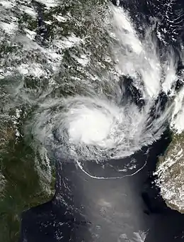
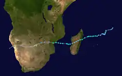
On 14 January, a zone of disturbed weather formed over the central South Indian Ocean, to the east of another system while gradually organizing and moving westward.[65] On 16 January, the system organized into a tropical depression.[66] With the presence of persisting deep convection, the system strengthened into Moderate Tropical Storm Eloise on 17 January.[67] Initially, Eloise struggled to develop further from the presence of strong easterly shear and dry air, which caused Eloise's thunderstorm activity to be displaced to the west.[68] Despite the presence of this shear and mid-level dry air, Eloise continued to intensify further, with convection wrapping into an eye feature and outflow becoming increasingly defined, marking the intensification of Eloise into a severe tropical storm on 19 January, while heading westward towards Madagascar.[69] This intensification trend did not last for a particularly long time, as Eloise made a small turn to the north and then made landfall in Antalaha, Madagascar, whilst weakening back to a moderate tropical storm, due to land interaction with the mountains of Madagascar.[70] The next day, Eloise weakened to a tropical depression due to land interaction, with deep convection over its center eroded though it maintained flaring convection over the northern semicircle.[71]
On 20 January, Eloise emerged into the Mozambique Channel. While in the Mozambique Channel, Eloise began to slowly reintensify with warm waters, a moist environment, little shear and weak divergence contributing to the storm's slow strengthening trend.[72] However, some upper-level convergence hindered convection from developing quickly, though all other factors were relatively favorable.[73] Soon afterward, the upper-level convergence began to decrease, allowing the system to strengthen more rapidly.[74] Eloise strengthened further with well defined rainbands wrapping into an small eye, marking its intensification into a tropical cyclone.[75] Early on 23 January, Eloise continued the quick intensification trend and peaked as a Category 2-equivalent tropical cyclone on the Saffir–Simpson scale with 10-minute sustained winds of 150 km/h (90 mph), 1-minute sustained winds of 165 km/h (105 mph), and a minimum central pressure of 967 millibars (28.6 inHg), as the storm's eyewall began moving ashore. Soon afterward, Eloise made landfall just north of Beira, Mozambique, at the same intensity.[76][77] As the storm moved further inland, Eloise weakened rapidly, due to interaction with the rugged terrain and dry air.[78] Later that day, Eloise weakened into a tropical depression as it tracked further inland.[79] On 25 January, Eloise degenerated into a remnant low, and the MFR issued their final advisory on the system.[80]
Moderate Tropical Storm Joshua
| Moderate tropical storm (MFR) | |
| Tropical storm (SSHWS) | |
  | |
| Duration | 17 January (Entered basin) – 19 January |
|---|---|
| Peak intensity | 85 km/h (50 mph) (10-min) 991 hPa (mbar) |
On 16 January, Meteo France La Rèunion (MFR) first noted the presence of a tropical low outside the basin, in the Australian region, which was expected to strengthen as it passed 90°E into the South-West Indian Ocean.[81] On 17 January, the system, which had become Tropical Cyclone Joshua the previous day, crossed into the MFR's area of responsibility (AOR).[82] Joshua's convection fluctuated on 18 January, but the storm held onto moderate tropical storm status.[83] However, Joshua entered a hostile environment with lots of dry air and wind shear, causing Joshua's thunderstorms to rapidly dissipate; Joshua weakened to tropical depression status the next day.[84] By 18:00 UTC 19 January, the Joint Typhoon Warning Center (JTWC) and MFR both issued their final warning on Joshua.[85][86]
Tropical Depression 09
| Tropical depression (MFR) | |
| Tropical depression (SSHWS) | |
  | |
| Duration | 27 January (Entered basin) – 28 January |
|---|---|
| Peak intensity | 55 km/h (35 mph) (10-min) 1001 hPa (mbar) |
On 27 January, Tropical Low 10U from the Australian region entered the basin and was designated as Tropical Depression 09.[87] Moving through a very hostile environment with dry air and high wind shear, the system struggled to strengthen with a mostly exposed circulation and only weak convection over the south side of the system.[88] A short time after entering the basin, Meteo France La Rèunion (MFR) issued their last warning on 12:00 UTC 28 January as the storm had become highly disorganized.[89]
Severe Tropical Storm Faraji
| |||
|---|---|---|---|
| |||
| As of: | 06:00 UTC, 6 February | ||
| Location: | 14.1°S 79.9°E | ||
| Sustained winds: | 55 knots (100 km/h; 65 mph) (10-min mean) 60 knots (110 km/h; 70 mph) (1-min mean) gusting to 75 knots (140 km/h; 85 mph) | ||
| Pressure: | 985 hPa (29.09 inHg) | ||
| Movement: | S at 5 kn (9.3 km/h; 5.8 mph) | ||
| See latest official information. | |||


Early on 4 February, MFR began to track a well-defined surface circulation developing southeast of the Chagos Archipelago.[90] Initially only having mixed support for development, the disturbance unexpectedly and rapidly developed into a tropical depression 18 hours later.[91] JTWC also issued their first warning on the system as Tropical Cyclone 19S at 9:00 UTC that day.[92] The depression further intensified to Moderate Tropical Storm Faraji at 12:00 UTC 5 February.[93] It had an intense band of intense deep convection wrapping in from the western side to the northern side, having rapidly consolidated.[94]
Current storm information
As of 06:00 UTC on 6 February, Severe Tropical Storm Faraji is located within 20 nautical miles of 14.1°S 79.9°E . It is currently moving south with the speed of 5 km/h (5 kn; 5 mph). Maximum 10-minute sustained winds are at 55 knots (100 km/h; 65 mph) while maximum 1-minute sustained winds are at 60 knots (110 km/h; 70 mph), with gusts up to 75 knots (140 km/h; 85 mph). The minimum central barometric pressure is 985 hPa (29.09 inHg).
For the latest official information see:
Storm names
Tropical depressions and subtropical depressions are assigned a name when they intensify to have 10-minute sustained winds of 65 km/h (40 mph) as assessed by the Regional Specialized Meteorological Center on La Réunion Island, France (RSMC La Réunion).[95] The Sub-Regional Tropical Cyclone Advisory Center in Mauritius assigns a name to a cyclone if it intensifies into a moderate tropical storm between 55°E and 90°E. A cyclone is assigned a name by the Sub-Regional Tropical Cyclone Advisory Center in Madagascar if it intensifies into a moderate tropical storm between 30°E and 55°E. From the 2016–17 season, name lists within the South-West Indian Ocean are rotated on a triennial basis. Storm names that are assigned during the season are used once. Therefore, all storm names used this year will be removed from rotation and replaced with a new name for the 2023–24 season, while the unused names will remain on the list.[96] The names used during the 2017–18 season were Ava, Berguitta, Cebile, Dumazile, Eliakim, and Fakir. This year they were replaced by Alicia, Bongoyo, Chalane, Danilo, Eloise, and Faraji.
|
|
Others
If a tropical cyclone enters the South-West Indian basin from the Australian region basin (west of 90°E), it will retain the name assigned to it by the Australian Bureau of Meteorology. The following storms were named in this manner:
- Joshua (named by BOM)
Season effects
This table lists all of the tropical cyclones and subtropical cyclones that were monitored during the 2020–2021 South-West Indian Ocean cyclone season. Information on their intensity, duration, name, areas affected, primarily comes from RSMC La Réunion. Death and damage reports come from either press reports or the relevant national disaster management agency while the damage totals are given in 2020 or 2021 USD.
| Name | Dates active | Peak classification | Sustained wind speeds |
Pressure | Areas affected | Damage (USD) |
Deaths | Refs |
|---|---|---|---|---|---|---|---|---|
| Alicia | 12 – 17 November | Tropical cyclone | 120 km/h (75 mph) | 975 hPa (28.79 inHg) | None | None | None | |
| 02 | 14 – 17 November | Tropical depression | 55 km/h (35 mph) | 999 hPa (29.50 inHg) | None | None | None | |
| Bongoyo | 4 – 10 December | Severe tropical storm | 100 km/h (65 mph) | 988 hPa (29.18 inHg) | Cocos Islands | None | None | |
| Chalane | 19 – 30 December | Severe tropical storm | 110 km/h (70 mph) | 983 hPa (29.03 inHg) | Madagascar, Mozambique, Zimbabwe, Botswana, Namibia | Unknown | 7 | [97] |
| 05 | 28 December – 3 January | Tropical depression | 55 km/h (35 mph) | 998 hPa (29.47 inHg) | Cocos Islands | None | None | |
| Danilo | 28 December – 12 January | Severe tropical storm | 100 km/h (65 mph) | 981 hPa (28.97 inHg) | Chagos Archipelago | None | None | |
| Eloise | 14 – 25 January | Tropical cyclone | 150 km/h (90 mph) | 967 hPa (28.56 inHg) | Madagascar, Mozambique, Malawi, Zimbabwe, South Africa, Eswatini | Unknown | 21 | [98] |
| Joshua | 17 – 19 January | Moderate tropical storm | 85 km/h (50 mph) | 991 hPa (29.26 inHg) | None | None | None | |
| 09 | 27 – 28 January | Tropical depression | 55 km/h (35 mph) | 1001 hPa (29.56 inHg) | None | None | None | |
| Faraji | 4 February – Present | Severe tropical storm | 100 km/h (65 mph) | 985 hPa (29.09 inHg) | None | None | None | |
| Season aggregates | ||||||||
| 10 systems | 12 November – Season ongoing | 150 km/h (90 mph) | 967 hPa (28.56 inHg) | Unknown | 28 | |||
See also
- List of Southern Hemisphere tropical cyclone seasons
- Tropical cyclones in 2020 and 2021
- Atlantic hurricane seasons: 2020, 2021
- Pacific hurricane seasons: 2020, 2021
- Pacific typhoon seasons: 2020, 2021
- North Indian Ocean cyclone seasons: 2020, 2021
- 2020–21 Australian region cyclone season
- 2020–21 South Pacific cyclone season
References
- "Tropical Disturbance 1 Warning Number 1/1/20202021" (PDF). Météo-France La Réunion. 12 November 2020. Retrieved 13 November 2020.
- "Tropical Cyclone Formation Alert (Invest 92S) Reissued". Joint Typhoon Warning Center. 13 November 2020. Archived from the original on 14 November 2020. Retrieved 14 November 2020.CS1 maint: unfit URL (link)
- "Tropical Depression 1 Warning Number 3/1/20202021" (PDF). Météo-France La Réunion. 13 November 2020. Retrieved 13 November 2020.
- "Moderate Tropical Storm 1 (Alicia) Warning Number 6/1/20202021" (PDF). Météo-France La Réunion. 13 November 2020. Retrieved 15 November 2020.
- "Severe Tropical Storm 1 (Alicia) Warning Number 8/1/20202021" (PDF). Météo-France La Réunion. 14 November 2020. Retrieved 15 November 2020.
- "Severe Tropical Storm 1 (Alicia) Warning Number 11/1/20202021" (PDF). Météo-France La Réunion. 15 November 2020. Retrieved 15 November 2020.
- "Tropical Cyclone 1 (Alicia) Warning Number 15/1/20202021" (PDF). Météo-France La Réunion. 16 November 2020. Retrieved 19 November 2020.
- "Severe Tropical Storm 1 (Alicia) Warning Number 17/1/20202021" (PDF). Météo-France La Réunion. 16 November 2020. Retrieved 19 November 2020.
- "TROPICAL CYCLONE 01S (ALICIA) WARNING NR 011". Joint Typhoon Warning Center. 17 November 2020. Retrieved 17 November 2020.
- "BULLETIN FOR CYCLONIC ACTIVITY AND SIGNIFICANT TROPICAL WEATHER IN THE SOUTHWEST INDIAN OCEAN DATE: 2020/11/12 AT 1200 UTC" (PDF). Meteo France La Reunion.
- "AWIO20 FMEE 141121 TROPICAL CYCLONE CENTER / RSMC LA REUNION / METEO-FRANCE BULLETIN FOR CYCLONIC ACTIVITY AND SIGNIFICANT TROPICAL WEATHER IN THE SOUTHWEST INDIAN OCEAN DATE: 2020/11/14 AT 1200 UTC" (PDF). Meteo France La Reunion.
- "A NUMERO DU BULLETIN : 1/2/20202021 A DEPRESSION TROPICALE 2" (PDF). Meteo France La Reunion.
- "0.A WARNING NUMBER: 3/2/20202021 1.A TROPICAL DEPRESSION 2" (PDF). Meteo France La Reunion.
- "Tropical Cyclone Formation Failure of Invest 93S".
- "0.A WARNING NUMBER: 4/2/20202021 1.A TROPICAL DEPRESSION 2" (PDF). Meteo France La Reunion.
- "Bulletin for Cyclonic Activity and Significant Tropical Weather in the Southwest Indian Ocean 2020/12/01 at 1200 UTC" (PDF). Météo-France La Réunion. 1 December 2020. Retrieved 4 December 2020.
- "TROPICAL CYCLONE FORMATION ALERT (INVEST 95S)". Joint Typhoon Warning Center. 4 December 2020. Retrieved 4 December 2020.
- "Tropical Disturbance 3 Warning Number 1/3/20202021". Meteo France La Reunion. 6 December 2020. Retrieved 6 December 2020.
- "Moderate Tropical Storm 2 (Bongoyo) Warning Number 5/3/20202021" (PDF). Meteo France La Reunion. 7 December 2020.
- "Tropical Cyclone 02S (Bongoyo) Warning #02". Joint Typhoon Warning Center. 7 December 2020. Archived from the original on 7 December 2020.
- "Severe Tropical Storm 3 (Bongoyo) Warning Number 9/3/20202021". Meteo France La Reunion.
- "Severe Tropical Storm 3 (Bongoyo) Warning Number 10/3/20202021". Meteo France La Reunion.
- "Severe Tropical Storm 3 (Bongoyo) Warning Number 12/3/20202021" (PDF). Meteo France La Reunion.
- "Moderate Tropical Storm 3 (Bongoyo) Warning Number 15/3/20202021". Meteo France La Reunion. 9 December 2020. Retrieved 11 December 2020.
- "A Remnant Low 3 (Bongoyo) Warning Number 20/3/20202021". Meteo France La Reunion. 11 December 2020. Retrieved 11 December 2020.
- "Tropical Cyclone 02S (Bongoyo) Warning #09". Joint Typhoon Warning Center. 11 December 2020. Archived from the original on 11 December 2020.
- "Tropical Cyclone Activity Bulletin for the South-West Indian Ocean (12Z)" (PDF). Météo-France La Réunion (in French). 19 December 2020. Retrieved 20 December 2020.
- "Significant Tropical Weather Advsiory for the Indian Ocean (18Z)". Joint Typhoon Warning Center. Naval Meteorology and Oceanography Command. 19 December 2020. Archived from the original on 20 December 2020. Retrieved 20 December 2020.
- "Tropical Depression 4 Warning 4/4/20202021". Meteo France La Reunion. 23 December 2020.
- "Moderate Tropical Storm 4 (Chalane) Warning Number 8/4/20202021". Meteo France La Reunion. 24 December 2020.
- "Moderate Tropical Storm 4 (Chalane) Warning Number 9/4/20202021". Meteo France La Reunion. 24 December 2020.
- "Tropical Cyclone Formation Alert WTXS21". Joint Typhoon Warning Center. 24 December 2020. Archived from the original on 24 December 2020.
- "TROPICAL CYCLONE 07S (CHALANE) WARNING NR 001". Joint Typhoon Warning Center. 24 December 2020. Retrieved 24 December 2020.
- "Tropical Depression 4 (Chalane) Warning Number 4/14/20202021". Meteo France La Reunion. 25 December 2020.
- "Tropical Depression 4 (Chalane) Warning Number 15/4/20202021" (PDF). Meteo France La Reunion. 26 December 2020.
- "Tropical Depression 4 (Chalane) Warning Number 18/4/20202021" (PDF). Meteo France La Reunion. 26 December 2020.
- "Overland Depression 4 (Chalane) Warning Number 19/4/20202021" (PDF). Meteo France La Reunion. 27 December 2020.
- "Tropical Depression 4 (Chalane) Warning Number 20/4/20202021" (PDF). Meteo France La Reunion. 28 December 2020.
- "Moderate Tropical Storm 4 (Chalane) Warning Number 21/4/20202021". Meteo France La Reunion. 28 December 2020.
- "Moderate Tropical Storm 4 (Chalane) Warning Number 22/4/20202021" (PDF). Meteo France La Reunion. 29 December 2020.
- "Severe Tropical Storm 4 (Chalane) Warning Number 23/4/20202021" (PDF). Meteo France La Reunion. 29 December 2020.
- "Information on CHALANE : 19/12/2020 TO 30/12/2020". Meteo France La Reunion. Retrieved 30 December 2020.
- "Moderate Tropical Storm 4 (Chalane) Warning Number 27/4/20202021" (PDF). Meteo France La Reunion. 30 December 2020.
- "Overland Depression 4 (Chalane) Warning Number 29/4/20202021" (PDF). Meteo France La Reunion. 30 December 2020.
- "Chalane takes aim at Mozambique after making first landfall in Madagascar". www.msn.com. Retrieved 28 December 2020.
- "Southern Africa, Flash Update No.3: Tropical Storm Chalane (as of 28 December 2020) - Madagascar". ReliefWeb. Retrieved 28 December 2020.
- "Tropical Cyclone Activity Bulletin for the South-West Indian Ocean (12Z)" (PDF). Météo-France La Réunion (in French). 17 December 2020. Retrieved 19 December 2020.
- "Tropical Cyclone Activity Bulletin for the South-West Indian Ocean (12Z)" (PDF). Météo-France La Réunion (in French). 18 December 2020. Retrieved 19 December 2020.
- "Significant Tropical Weather Advisory for the Indian Ocean (18Z)". Joint Typhoon Warning Center. Naval Meteorology and Oceanography Command. 18 December 2020. Archived from the original on 19 December 2020. Retrieved 19 December 2020.
- "Tropical Cyclone Activity Bulletin for the South-West Indian Ocean (12Z)" (PDF). Météo-France La Réunion (in French). 20 December 2020. Retrieved 20 December 2020.
- "Tropical Cyclone Outlook for the Western Region (04Z)". Australian Bureau of Meteorology. 20 December 2020. Archived from the original on 20 December 2020. Retrieved 20 December 2020.
- "Tropical Depression 5 Warning Number 3/5/20202021" (PDF). Meteo France La Reunion. 31 December 2020.
- "Bulletin of Zone of Disturbed Weather 06" (PDF). Meteo France La Reunion. 31 December 2020. Retrieved 31 December 2020.
- "Moderate Tropical Storm 6 (Danilo) Warning Number 6/6/20202021" (PDF). Meteo France La Reunion. 1 January 2021.
- "Moderate Tropical Storm 6 (Danilo) Warning Number 10/6/20202021". Meteo France La Reunion. 2 January 2021.
- "A Moderate Tropical Storm 6 (Danilo) Warning Number 11/6/20202021" (PDF). Meteo France La Reunion. 2 January 2021.
- "A Severe Tropical Storm 6 (Danilo) Warning Number 15/6/20202021" (PDF). Meteo France La Reunion. 3 January 2021.
- "A Moderate Tropical Storm 4 (Danilo) Warning Number 17/6/20202021" (PDF). Meteo France La Reunion. 4 January 2021.
- "Severe Tropical Storm 6 (Danilo) Warning Number 21/6/20202021" (PDF). Meteo France La Reunion. 5 January 2021.
- "Moderate Tropical Storm 6 (Danilo) Warning Number 23/6/20202021" (PDF). Meteo France La Reunion.
- "A Moderate Tropical Storm 6 (Danilo) Warning Number 25/6/20202021" (PDF). Meteo France La Reunion. 6 January 2021.
- "Tropical Depression 6 (Danilo) Warning Number 27/6/20202021" (PDF). Meteo France La Reunion. 5 January 2021.
- "A Remnant Low 6 (Danilo) Warning Number 37/6/20202021" (PDF). Meteo France La Reunion. 9 January 2021.
- "A Remnant Low 6 (Danilo) Warning Number 48/6/20202021" (PDF). Meteo France La Reunion. 12 January 2021.
- "Tropical Cyclone Activity Bulletin for the South-West Indian Ocean" (PDF). Meteo France La Reunion. 15 January 2021. Retrieved 15 January 2021.
- "Tropical Cyclone Activity Bulletin for the South-West Indian Ocean" (PDF). Meteo France La Reunion. 15 January 2021. Retrieved 16 January 2021.
- "Moderate Tropical Storm 7 (Eloise)" (PDF). Meteo France La Reunion. 17 January 2021. Retrieved 17 January 2021.
- "Moderate Tropical Storm 7 (Eloise)" (PDF). 18 January 2021.
- "Severe Tropical Storm 7 (Eloise) Warning Number 14/07/20202021" (PDF). Meteo France La Reunion. 19 January 2021.
- "A Moderate Tropical Storm 4 (Eloise) Warning Number 17/7/20202021" (PDF). Meteo France La Reunion. 19 January 2021.
- "TROPICAL CYCLONE 12S (ELOISE) WARNING NR 007". Joint Typhoon Warning Center.
- "MODERATE TROPICAL STORM 7 (ELOISE)" (PDF). Météo-France. Retrieved 20 January 2021.
- "TROPICAL CYCLONE 12S (ELOISE) WARNING NR 009". Joint Typhoon Warning Center.
- "TROPICAL CYCLONE 12S (ELOISE) WARNING NR 010". Joint Typhoon Warning Center.
- "TROPICAL CYCLONE 12S (ELOISE) WARNING NR 011".
- "A Tropical Cyclone 7 (Eloise) Warning Number 30/7/20202021". Meteo France La Reunion. 23 January 2021.
- "TROPICAL CYCLONE 12S (ELOISE) WARNING NR 012".
- "TROPICAL CYCLONE 12S (ELOISE) WARNING NR 013".
- "OVERLAND DEPRESSION 7 (ELOISE)" (PDF). Meteo France La Reunion. 23 January 2021. Retrieved 25 January 2021.
- "Overland Depression 7 (Eloise) Warning Number 39/7/20202021" (PDF). Meteo France La Reunion. 25 January 2021. Retrieved 25 January 2021.
- "Bulletin For Cyclonic Activity And Significant Tropical Weather In The Southwest Indian Ocean: 2020/01/06 at 12:00 UTC" (PDF). Meteo France La Reunion. 16 January 2021.
- "A Moderate Tropical Storm 8 (Joshua) Warning Number 1/8/20202021" (PDF). Meteo France La Reunion. 17 January 2021.
- "Moderate Tropical Storm 8 (Joshua) Warning Number 3/8/20202021" (PDF). Meteo France La Reunion. 18 January 2021.
- "A Tropical Depression 8 (Joshua) Warning Number 6/8/20202021" (PDF). Meteo France La Reunion. 19 January 2021.
- "TROPICAL CYCLONE 10S (JOSHUA) WARNING NR 008". metoc.navy.mil. Joint Typhoon Warning Center. 18 January 2021. Retrieved 19 January 2021.
- "A Filling Up 8 (Joshua) Warning Number 7/8/20202021" (PDF). Meteo France La Reunion. 19 January 2021.
- "A NUMERO DU BULLETIN : 1/9/20202021" (PDF).
- "A Tropical Depression 9 Warning Number 2/9/20202021" (PDF). Meteo France La Reunion. 28 January 2021.
- "Tropical Depression 09 Warning Number 3/9/20202021" (PDF). Meteo France La Reunion. 28 January 2021.
- "BULLETIN FOR CYCLONIC ACTIVITY AND SIGNIFICANT TROPICAL WEATHER IN THE SOUTHWEST INDIAN OCEAN 2021/02/04 AT 1200 UTC". Meteo France La Reunion. 4 February 2021.
- "A Tropical Depression 10 Warning Number 1/10/20202021". Meteo France La Reunion. 5 February 2021.
- "TROPICAL CYCLONE 19S (NINETEEN) WARNING NR 001". Joint Typhoon Warning Center. 5 February 2021. Retrieved 5 February 2021.
- "A Moderate Tropical Storm 10 (Faraji) Warning Number 2/10/2021". Meteo France La Reunion. 5 February 2021.
- "TROPICAL CYCLONE 19S (FARAJI) WARNING NR 002".
- "System Names for the Current Season". Meteo France La Reunion. Retrieved 15 November 2020.
- Regional Association I Tropical Cyclone Committee (2016). "Tropical Cyclone Operational Plan for the South-West Indian Ocean" (PDF). World Meteorological Organization. Retrieved 5 October 2016.
- "Death toll from storm Chalane in Mozambique rises to 7 | Nation". nation.africa. Retrieved 3 January 2021.
- "Southern Africa – Tropical Cyclone Eloise Flash Update No.5, As of 22 January 2021". ReliefWeb. 22 January 2021. Retrieved 22 January 2021.
External links
| Wikimedia Commons has media related to 2020-21 South-West Indian Ocean cyclone season. |