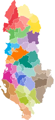
Administrative divisions of Albania
Since the Declaration of Independence in 1912, Albania has undergone administrative territorial reforms a total of 21 times. Its administrative boundaries have been divided and/or merged into regions (krahina), prefectures, sub-prefectures, counties (qarqe), districts (rrethe), municipalities (bashki), cities, communes (komuna), neighborhoods (lagje), villages (fshatra) and localities. The country is presently divided into 61 municipalities and 373 units of local governance.[1] [2][3]
| Administrative divisions of Albania Ndarja Administrative e Republikës së Shqipërisë (Albanian) | |
|---|---|
 | |
| Category | Unitary state |
| Location | |
| Number | 12 counties; 61 municipalities |
| Populations | Total: 2,845,955 |
| Areas | Total: 28,748 km2 (11,100 sq mi) |
Current administrative divisions (since 2014)
Counties
Counties are the first level of local governance and are administered by the prefect (prefekti) and a county council (këshilli i qarkut). The prevect is appointed as a representative of the Council of Ministers.[4] After 2000, there are 12 counties in total.[3]
Municipalities
The second level of government is constituted by the municipalities (bashki), which have resulted from merging several former municipalities and communities. They are run by a mayor (kryebashkiak or kryetar bashkie) and a municipal council (këshilli bashkiak), elected every 4 years. The municipalities are further subdivided into units of local governance (njësi të qeverisjes vendore). After 2014, there are 61 municipalities in total.[5]
Units
There are 373 units within Albania.
History
1912 to 1924
Following the proclamation of Albania's independence from the Ottoman Empire, the first Albanian government led by Ismail Qemali accepted the administrative organization sanctioned in the "Appropriate Kanun of the Albanian Civil Administration" announced on November 22, 1913, according to which the country was divided into three main levels. In the first level, the territory was divided into 8 prefectures (Durrës; Berat; Dibër; Elbasan; Gjirokastër; Korcë; Shkodër and Vlorë) governed by prefect. The second and third administrative divisions were the sub-prefectures and provinces.[6]
1925 to 1945
During 1925-1945, the Albanian administrative territory was divided into several divisions. According to the "Municipal Organic Law" adopted in 1921 and thereafter, with the "Civil Code" adopted in February 1928, the administrative division was:
Municipality (Albanian: Bashki). Became operational after 1928. It was mainly an element used in settlements of urban areas or cities. They were governed by the mayor and municipal council elected by citizens every three years.
Village (Albanian: Fshat). The village was the initial unit of the local administration. The villages was ruled by the chief of village who was elected by the rural population where he ruled.
Commune (Albanian: Komunë). The communes also became operational after 1928 (before 1928 was called Provinces (Krahinë)). It included several villages on the basis of tradition and social relations, ease of communication, the possibility of realizing the needs of residents, etc. The communes center become the village where there were facilities to move the inhabitants or the goods of all the villages that were part of the commune.
Sub-prefecture (Albanian: Nënprefekturë). It was the third level of local government, led by the sub-prefect, who was nominated by the prefect. The functions of the sub-prefecture consisted in the organization of order, civil status services etc.
Prefecture (Albanian: Prefekturë). Was the largest local government unit. The prefecture and the sub-prefecture exercised only executive functions.[6][7]
1945 to 1992
After the end of World War II, by mid-1946, Albania continued with the existing administrative division with 10 prefectures (prefekturë) and 61 sub-prefectures (nënprefekturë), but was abolished the element of commune (komunë) and municipality (bashki).
In September 1945, population census was conducted. By Law No. 284, dated August 22, 1946, the new administrative division was approved, which maintained as the first division level of 10 prefectures and lowered the number of sub-prefectures in 39 units, introducing a new element to the locality (lokalitet), but not much extended. In 1947, the locality gained extensive use by dividing the country into 10 prefectures, 2 subdivisions called districts (rrethe), and further into localities, villages and towns.[8]
By law no. 1707, in 1953, was moved to a new administrative division, where as the largest administrative unit was admitted to be 10 counties (qark), divided into 49 districts and 30 localities.
In July 1958, the county was abolished, dividing the country into 26 districts. The city of Tirana maintained the level of the district. According to this division, there were 26 districts, 203 localities, 2655 villages, 39 cities and some of them had neighborhoods as the smallest administrative unit.
After 1967 a new sub-division called united villages (fshat i bashkuar) was introduced. In 1968 there were 26 districts, 437 united villages, 2641 villages, 65 cities and 178 urban neighborhoods. This administrative division was preserved until the late 1980s, with some minor changes. In 1990 there were 26 districts, 539 united villages, 2848 villages, 67 cities, 306 urban neighborhoods. The city of Tirana consisted of three regions, which included several neighborhoods.[6]
References
- 61 bashkitë do të drejtohen dhe shërbejnë sipas “modelit 1958”
- "HARTA AD MINIST RATIVE TERRITORIALE E BASHKIVE TË SHQIPËRISË" (PDF). Reformaterritoriale.al. Retrieved 2017-09-09.
- "HARTA AD MINIST RATIVE TERRITORIALE E QARQEVE TË SHQIPËRISË" (PDF). Reformaterritoriale.al. Retrieved 2017-09-09.
- "LIGJ Nr. 8927, date 25.7.2002 : Per Prefektin (Ndryshuar me Ligjin Nr. 49/2012 "Për Organizimin dhe Funksionimin e Gjykatave : Administrative dhe Gjykimin r Mosmarrëveshjeve Administrative"" (PDF). Planifikimi.gov.al. Retrieved 2017-09-09.
- "HARTA ADMINISTRATIVE TERRITORIALE E BASHKIVE TË SHQIPËRISË" (PDF). Ceshtjetvendore.gov.al. Archived from the original (PDF) on 2016-03-06. Retrieved 2017-09-09.
- "Reforma Territoriale - Historik". Reformaterritoriale.al. Retrieved 9 September 2017.
- ""Historia e ndarjes administrative nga Ismail Qemali në '92"". Panorama.com.al. Retrieved 9 September 2017.
- "Historia e ndarjes administrative nga Ismail Qemali në '92". Shtetiweb.org. Retrieved 9 September 2017.
