Aisai
Aisai (愛西市, Aisai-shi) is a city located in Aichi Prefecture, Japan. As of 1 October 2019, the city had an estimated population of 61,320 in 23,451 households,[1] and a population density of 919 persons per km². The total area of the city is 66.70 square kilometres (25.75 sq mi). Aisai is a member of the World Health Organization’s Alliance for Healthy Cities (AFHC).[2]
Aisai
愛西市 | |
|---|---|
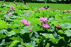 Morikawa lotus field | |
 Flag  Emblem | |
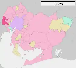 Location of Aisai in Aichi Prefecture, highlighted in pink | |
 Aisai | |
| Coordinates: 35°9′10″N 136°43′41.6″E | |
| Country | Japan |
| Region | Chūbu (Tōkai) |
| Prefecture | Aichi |
| Area | |
| • Total | 66.70 km2 (25.75 sq mi) |
| Population (October 1, 2019) | |
| • Total | 61,320 |
| • Density | 920/km2 (2,400/sq mi) |
| Time zone | UTC+9 (Japan Standard Time) |
| - Tree | Podocarpaceae |
| - Flower | Nelumbo nucifera |
| Phone number | 0567-26-8111 |
| Address | Yoneno 308,Inaba-cho, Aisai-shi, Aichi-ken 496-8555 |
| Website | Official website |
Geography
Aisai is located in the coastal flatlands of far western Aichi Prefecture, bordering Gifu Prefecture on the west. It has a short border with Mie Prefecture to the southwest. The Kiso River and the Nagara River pass through the city.
Surrounding municipalities
- Aichi Prefecture
- Mie Prefecture
- Gifu Prefecture
Demographics
Per Japanese census data,[3] the population of Aisai has been relatively steady over the past 30 years.
| Year | Pop. | ±% |
|---|---|---|
| 1960 | 38,629 | — |
| 1970 | 48,104 | +24.5% |
| 1980 | 61,337 | +27.5% |
| 1990 | 63,143 | +2.9% |
| 2000 | 65,597 | +3.9% |
| 2010 | 64,981 | −0.9% |
Climate
The city has a climate characterized by hot and humid summers, and relatively mild winters (Köppen climate classification Cfa). The average annual temperature in Aisai is 15.5 °C. The average annual rainfall is 1730 mm with September as the wettest month. The temperatures are highest on average in August, at around 27.8 °C, and lowest in January, at around 4.3 °C.[4]
| Climate data for Aisai (1981-2010) | |||||||||||||
|---|---|---|---|---|---|---|---|---|---|---|---|---|---|
| Month | Jan | Feb | Mar | Apr | May | Jun | Jul | Aug | Sep | Oct | Nov | Dec | Year |
| Record high °C (°F) | 16.5 (61.7) |
19.3 (66.7) |
24.3 (75.7) |
29.1 (84.4) |
33.6 (92.5) |
36.8 (98.2) |
39.0 (102.2) |
40.3 (104.5) |
37.9 (100.2) |
31.8 (89.2) |
25.2 (77.4) |
22.0 (71.6) |
40.3 (104.5) |
| Average high °C (°F) | 8.6 (47.5) |
9.6 (49.3) |
13.3 (55.9) |
19.4 (66.9) |
23.8 (74.8) |
27.2 (81.0) |
30.9 (87.6) |
32.8 (91.0) |
28.6 (83.5) |
22.8 (73.0) |
16.9 (62.4) |
11.4 (52.5) |
20.4 (68.7) |
| Daily mean °C (°F) | 3.9 (39.0) |
4.6 (40.3) |
8.0 (46.4) |
13.7 (56.7) |
18.4 (65.1) |
22.4 (72.3) |
26.0 (78.8) |
27.4 (81.3) |
23.5 (74.3) |
17.4 (63.3) |
11.5 (52.7) |
6.2 (43.2) |
15.2 (59.4) |
| Average low °C (°F) | −0.1 (31.8) |
0.3 (32.5) |
3.3 (37.9) |
8.5 (47.3) |
13.7 (56.7) |
18.5 (65.3) |
22.5 (72.5) |
23.6 (74.5) |
19.6 (67.3) |
12.9 (55.2) |
6.8 (44.2) |
1.9 (35.4) |
10.9 (51.6) |
| Record low °C (°F) | −7.8 (18.0) |
−8.5 (16.7) |
−7.5 (18.5) |
−0.8 (30.6) |
4.7 (40.5) |
12.0 (53.6) |
16.2 (61.2) |
15.8 (60.4) |
10.6 (51.1) |
2.0 (35.6) |
−1.7 (28.9) |
−6.0 (21.2) |
−8.5 (16.7) |
| Average precipitation mm (inches) | 55.0 (2.17) |
73.2 (2.88) |
138.6 (5.46) |
150.6 (5.93) |
180.1 (7.09) |
224.0 (8.82) |
221.8 (8.73) |
144.5 (5.69) |
228.2 (8.98) |
127.4 (5.02) |
92.1 (3.63) |
50.6 (1.99) |
1,686.3 (66.39) |
| Mean monthly sunshine hours | 149.1 | 158.0 | 186.5 | 196.3 | 191.9 | 152.5 | 169.9 | 205.8 | 159.4 | 164.8 | 154.9 | 148.8 | 2,037.1 |
| Source: Japan Meteorological Agency (JMA)[5] | |||||||||||||
History
During the Edo period, the area of modern Aisai was controlled by the Yokoi clan, retainers of the Owari Tokugawa of Nagoya. During the Meiji period, the area was organized into several villages under Kasai District and Kaito District, Aichi Prefecture, which later became Ama District, Aichi in the Taishō period.
The city of Aisai was created through the merger on April 1, 2005 of the towns of Saya and Saori and villages of Hachikai and Tatsuta.
Government
Aisai has a mayor-council form of government with a directly elected mayor and a unicameral city legislature of 18 members. The city contributes one member to the Aichi Prefectural Assembly. In terms of national politics, the city is part of Aichi District 8 of the lower house of the Diet of Japan.
Education
Aisai has twelve public elementary schools and eight public junior high schools operated by the city government, and two public high schools operated by the Aichi Prefectural Board of Education. There are also two private high schools. The prefecture also operates one special education school for the handicapped.
Economy
Aisai is noted for its production of edible lotus root. Other main agricultural include ginger, strawberries, tomatoes, and the brewing of sake.
Transportation
Railways
Notable people from Aisai
- Katō Takaaki , pre-war Prime Minister of Japan
- Shoichi Yokoi, Imperial Japanese Army holdout found in Guam
- Daiki Wakamatsu, professional soccer player
Gallery
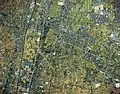 Saya district Aisai city Aerial photograph
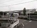 Kracie Tsushima Factory
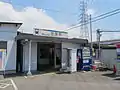 MT-Saya Station-Building
 Nagaragawa Bridge and Tatsuta Bridge
References
- Aisai City official statistics (in Japanese)
- Alliance for Healthy Cities official home page
- Aisai population statistics
- Aisai climate data
- "Aisai 1981-2010". JMA. Retrieved July 11, 2016.
External links
- Aisai City official website (in Japanese)
 Media related to Aisai, Aichi at Wikimedia Commons
| Nagoya |
| |||
|---|---|---|---|---|
| Core cities | ||||
| Special cities | ||||
| Cities | ||||
| Districts | ||||
| Authority control |
|---|