Yatomi
Yatomi (弥富市, Yatomi-shi) is a city located in Aichi Prefecture, Japan. As of 1 December 2019, the city had an estimated population of 44,589 in 18,185 households and a population density of 910 persons per km².[1] The total area of the city is 49.0 square kilometres (18.9 sq mi). The between of the border, and neighboring town of Kanie.
Yatomi
弥富市 | |
|---|---|
 | |
 Flag  Seal | |
 Location of Yatomi in Aichi Prefecture | |
 Yatomi | |
| Coordinates: 35°7′N 136°43′E | |
| Country | Japan |
| Region | Chūbu (Tōkai) |
| Prefecture | Aichi |
| Area | |
| • Total | 49.00 km2 (18.92 sq mi) |
| Population (December 1, 2019) | |
| • Total | 44,589 |
| • Density | 910/km2 (2,400/sq mi) |
| Time zone | UTC+9 (Japan Standard Time) |
| - Tree | Sakura |
| - Flower | Antirrhinum majus |
| Phone number | 0567-65-1111 |
| Address | Minamihonda 335,Maesu-cho, Yatomi-shi, Aichi-ken 498-8501 |
| Website | Official website |
.jpg.webp)
.jpg.webp)

Geography
Yatomi is located in the coastal flatlands of far western Aichi Prefecture, bordering Mie Prefecture on the west. It has a short coastline with Mikawa Bay on the Pacific Ocean to the southeast.
Demographics
Per Japanese census data,[2] the population of Yatomi has grown steadily over the past 60 years.
| Year | Pop. | ±% |
|---|---|---|
| 1960 | 20,440 | — |
| 1970 | 27,311 | +33.6% |
| 1980 | 36,457 | +33.5% |
| 1990 | 38,971 | +6.9% |
| 2000 | 42,175 | +8.2% |
| 2010 | 43,280 | +2.6% |
Climate
The city has a climate characterized by hot and humid summers, and relatively mild winters (Köppen climate classification Cfa). The average annual temperature in Yatomi is 15.6 °C. The average annual rainfall is 1677 mm with September as the wettest month. The temperatures are highest on average in August, at around 27.7 °C, and lowest in January, at around 4.5 °C.[3]
History
The area name of Yatomi appears in Kamakura period documents, as part of ancient Owari Province. During the Edo period, the area was noted for raising ornamental goldfish. During the Meiji period, the area was organized into villages under Kasai District, Aichi Prefecture, with the establishment of the modern municipalities system. Kasai District later became Ama District, Aichi. Yatomi was proclaimed a town on August 26, 1903. The Isewan Typhoon of September 26, 1959 created extensive damage to the area. Efforts to merge Yatomi with the neighboring town of Kanie failed in 2004 over a dispute on the naming of the new entity.
The city of Yatomi was founded on April 1, 2006, from the merger between the former town of Yatomi, absorbing the village of Jūshiyama (both from Ama District).
Government
Yatomi has a mayor-council form of government with a directly elected mayor and a unicameral city legislature of 16 members. The city contributes two members to the Aichi Prefectural Assembly. In terms of national politics, the city is part of Aichi District 9 of the lower house of the Diet of Japan.
Education
Yatomi has eight public elementary schools and threepublic junior high schools operated by the city government, and one public high school operated by the Aichi Prefectural Board of Education. There is also one private high school.
Economy

Yatomi is a regional commercial center, and is noted for hothouse agriculture. Main agricultural products include rice, wheat, lettuce, tomatoes, and carnations.
Transportation
Railways
.jpg.webp)
.jpg.webp)
Notable people from Yatomi
- Ōnishiki Daigorō, Sumo Wrestler
- Umanosuke Ueda, professional wrestler and sports commentator
Local attractions
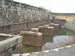
- Tatsuta polder sluice gates
- Yatomi Wild Bird Sanctuary
- Mitsumata-pond park
References
External links
![]() Media related to Yatomi, Aichi at Wikimedia Commons
Media related to Yatomi, Aichi at Wikimedia Commons
- Yatomi City official website (in Japanese)
| Nagoya |
| |||
|---|---|---|---|---|
| Core cities | ||||
| Special cities | ||||
| Cities | ||||
| Districts | ||||