Almont, North Dakota
Almont is a city in Morton County, North Dakota, United States. It is part of the "Bismarck, ND Metropolitan Statistical Area" or "Bismarck–Mandan". The population was 122 at the 2010 census.[6] Almont was founded in 1906, incorporated in 1936, and reached a peak population of 232 in 1940. The Northern Pacific Railroad tracks were removed in 1947 when the mainline was rerouted, and the city has since withered to just above 100 residents.
Almont, North Dakota | |
|---|---|
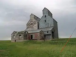 An old grain elevator in Almont | |
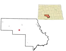 Location of Almont, North Dakota | |
| Coordinates: 46°43′38″N 101°30′23″W[1] | |
| Country | United States |
| State | North Dakota |
| County | Morton |
| Founded | 1906 |
| Area | |
| • Total | 2.49 sq mi (6.46 km2) |
| • Land | 2.49 sq mi (6.46 km2) |
| • Water | 0.00 sq mi (0.00 km2) |
| Elevation | 1,919 ft (585 m) |
| Population | |
| • Total | 122 |
| • Estimate (2019)[4] | 119 |
| • Density | 47.71/sq mi (18.42/km2) |
| Time zone | UTC-6 (Central (CST)) |
| • Summer (DST) | UTC-5 (CDT) |
| ZIP code | 58520 |
| Area code(s) | 701 |
| FIPS code | 38-01700 |
| GNIS feature ID | 1027687[5] |
| Website | sims-almont.us |
Geography
Almont is located on County Road 86, about 10 miles (16 km) south of Interstate 94.
According to the United States Census Bureau, the city has a total area of 2.64 square miles (6.84 km2), all of it land.[7]
Demographics
| Historical population | |||
|---|---|---|---|
| Census | Pop. | %± | |
| 1940 | 232 | — | |
| 1950 | 190 | −18.1% | |
| 1960 | 190 | 0.0% | |
| 1970 | 109 | −42.6% | |
| 1980 | 146 | 33.9% | |
| 1990 | 117 | −19.9% | |
| 2000 | 89 | −23.9% | |
| 2010 | 122 | 37.1% | |
| 2019 (est.) | 119 | [4] | −2.5% |
| U.S. Decennial Census[8] 2018 Estimate[9] | |||
2010 census
As of the census[3] of 2010, there were 122 people, 51 households, and 30 families living in the city. The population density was 46.2 inhabitants per square mile (17.8/km2). There were 66 housing units at an average density of 25.0 per square mile (9.7/km2). The racial makeup of the city was 100.0% White.
There were 51 households, of which 29.4% had children under the age of 18 living with them, 52.9% were married couples living together, 3.9% had a female householder with no husband present, 2.0% had a male householder with no wife present, and 41.2% were non-families. 37.3% of all households were made up of individuals, and 27.4% had someone living alone who was 65 years of age or older. The average household size was 2.39 and the average family size was 3.23.
The median age in the city was 41.8 years. 27.9% of residents were under the age of 18; 6.5% were between the ages of 18 and 24; 18.8% were from 25 to 44; 32.8% were from 45 to 64; and 13.9% were 65 years of age or older. The gender makeup of the city was 49.2% male and 50.8% female.
2000 census
As of the census of 2000, there were 89 people, 43 households, and 22 families living in the city. The population density was 33.8 people per square mile (13.1/km2). There were 63 housing units at an average density of 23.9 per square mile (9.2/km2). The racial makeup of the city was 100.0% White.
There were 43 households, out of which 25.6% had children under the age of 18 living with them, 44.2% were married couples living together, 4.7% had a female householder with no husband present, and 48.8% were non-families. 44.2% of all households were made up of individuals, and 23.3% had someone living alone who was 65 years of age or older. The average household size was 2.07 and the average family size was 3.00.
In the city, the population was spread out, with 24.7% under the age of 18, 5.6% from 18 to 24, 28.1% from 25 to 44, 23.6% from 45 to 64, and 18.0% who were 65 years of age or older. The median age was 40 years. For every 100 females, there were 81.6 males. For every 100 females age 18 and over, there were 86.1 males.
The median income for a household in the city was $25,625, and the median income for a family was $30,625. Males had a median income of $24,375 versus $15,000 for females. The per capita income for the city was $13,761. There were no families and 6.4% of the population living below the poverty line, including no under eighteens and 38.9% of those over 64.
Climate
This climatic region is typified by large seasonal temperature differences, with warm to hot (and often humid) summers and cold (sometimes severely cold) winters. According to the Köppen Climate Classification system, Almont has a humid continental climate, abbreviated "Dfb" on climate maps.[10]
References
- "US Gazetteer files: 2010, 2000, and 1990". United States Census Bureau. February 12, 2011. Retrieved April 23, 2011.
- "2019 U.S. Gazetteer Files". United States Census Bureau. Retrieved July 27, 2020.
- "U.S. Census website". United States Census Bureau. Retrieved June 14, 2012.
- "Population and Housing Unit Estimates". United States Census Bureau. May 24, 2020. Retrieved May 27, 2020.
- "US Board on Geographic Names". United States Geological Survey. October 25, 2007. Retrieved January 31, 2008.
- "2010 Census Redistricting Data (Public Law 94-171) Summary File". American FactFinder. United States Census Bureau. Retrieved May 2, 2011.
- "US Gazetteer files 2010". United States Census Bureau. Archived from the original on January 25, 2012. Retrieved June 14, 2012.
- United States Census Bureau. "Census of Population and Housing". Retrieved July 19, 2013.
- "Population Estimates". United States Census Bureau. Retrieved September 10, 2019.
- Climate Summary for Almont, North Dakota
Municipalities and communities of Morton County, North Dakota, United States | ||
|---|---|---|
| Cities |  Map of North Dakota highlighting Morton County | |
| Township | ||
| CDP | ||
| Unincorporated communities | ||
| ||
| Counties |  | |
|---|---|---|
| Core cities | ||
| Surrounding areas |
| |
External links
| Authority control |
|
|---|