Alsea, Oregon
Alsea is an unincorporated community in Benton County, in the U.S. state of Oregon. It is on Oregon Route 34 and the Alsea River. For statistical purposes, the United States Census Bureau has defined Alsea as a census-designated place (CDP). The census definition of the area may not precisely correspond to local understanding of the area with the same name. As of the 2010 Census, the population was 164.[1]
Alsea, Oregon | |
|---|---|
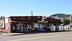 Alsea Mercantile | |
 Alsea, Oregon Location within the state of Oregon  Alsea, Oregon Alsea, Oregon (the United States) | |
| Coordinates: 44°22′53″N 123°35′47″W | |
| Country | United States |
| State | Oregon |
| County | Benton |
| Named for | Alsea River |
| Elevation | 292 ft (89 m) |
| Population | |
| • Total | 164 |
| Time zone | UTC-8 (PST) |
| • Summer (DST) | UTC-7 (PDT) |
| ZIP codes | 97324 |
| Area code(s) | 541 |
| Coordinates and elevation from Geographic Names Information System[2] | |
History
Alsea was named for the Alsea River, whose name was a corruption of "Alsi" (also spelled "Ulseah" and "Alsiias") the name of a Native American tribe, now known as the Alsea, that lived at the mouth of the river. The Alsea area was settled by Europeans early as 1855, when the name "Alseya Settlement" appeared on the Surveyor General's map. Alsea post office was established in 1871.[3]
In the early 1850s settlers moved from the Willamette Valley into the Alsea area to take up donation land claims.[4] While logging was once the primary industry in Alsea, it is now known as a place for fishing on the Alsea River, particularly for steelhead,[5] and a favorite stopping point on a well-traveled cycling loop.[6]
Climate
This region experiences warm (but not hot) and dry summers, with no average monthly temperatures above 71.6 °F (22.0 °C). According to the Köppen Climate Classification system, Alsea has a warm-summer Mediterranean climate, abbreviated "Csb" on climate maps.[7]
| Climate data for Alsea Fish Hatchery | |||||||||||||
|---|---|---|---|---|---|---|---|---|---|---|---|---|---|
| Month | Jan | Feb | Mar | Apr | May | Jun | Jul | Aug | Sep | Oct | Nov | Dec | Year |
| Record high °F (°C) | 13 (55) |
16 (61) |
18 (65) |
28 (82) |
34 (94) |
33 (92) |
35 (95) |
32 (90) |
28 (83) |
20 (68) |
17 (62) |
13 (55) |
35 (95) |
| Average high °F (°C) | 7.9 (46.2) |
9.0 (48.2) |
10.1 (50.2) |
13 (55) |
16.5 (61.7) |
18.9 (66.1) |
23.6 (74.5) |
23.3 (73.9) |
20.7 (69.2) |
14.1 (57.3) |
9.6 (49.2) |
5.7 (42.2) |
14.3 (57.8) |
| Average low °F (°C) | 2.4 (36.3) |
2.1 (35.8) |
2.5 (36.5) |
3.4 (38.2) |
5.8 (42.4) |
8.6 (47.4) |
9.9 (49.8) |
10.3 (50.5) |
8.8 (47.9) |
6.2 (43.2) |
4.2 (39.6) |
0.6 (33.1) |
5.4 (41.7) |
| Record low °F (°C) | −4 (25) |
−8 (17) |
−3 (26) |
−3 (27) |
−1 (30) |
3 (38) |
4 (40) |
4 (39) |
4 (39) |
−1 (30) |
−2 (28) |
−12 (11) |
−12 (11) |
| Average precipitation inches (mm) | 377 (14.85) |
284 (11.17) |
283 (11.15) |
180 (6.9) |
103 (4.05) |
60 (2.38) |
17 (0.65) |
28 (1.12) |
72 (2.85) |
166 (6.52) |
354 (13.94) |
410 (16.3) |
2,334 (91.89) |
| Average snowfall inches (cm) | 4.3 (1.7) |
3.6 (1.4) |
1.3 (0.5) |
0 (0) |
0 (0) |
0 (0) |
0 (0) |
0 (0) |
0 (0) |
0 (0) |
0.25 (0.1) |
3.0 (1.2) |
12 (4.9) |
| Average precipitation days | 20 | 17 | 20 | 17 | 12 | 9 | 4 | 5 | 8 | 13 | 19 | 20 | 164 |
| Source: [8] | |||||||||||||
Covered bridge
Near Alsea is Hayden Bridge, a historic covered bridge listed on the National Register of Historic Places in 1979.[9] The bridge carries Hayden Road over the river from an intersection with Route 34 about 2 miles (3 km) west of Alsea.[10]
Notable people
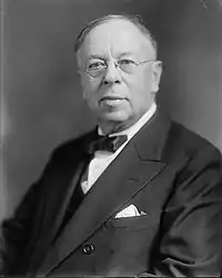
- Thomas Benton Slate (December 2, 1880 – November 26, 1980) – was raised in Alsea. He invented the first commercially viable method of producing dry ice[11] and later financed construction of an all-aluminum hulled airship, The City of Glendale, completed in 1929 but never flown.[12]
References
- "Population and Housing Occupancy Status: 2010". U.S. Census Bureau. Retrieved December 3, 2014.
- "Alsea". Geographic Names Information System. United States Geological Survey. November 28, 1980. Retrieved September 11, 2009.
- McArthur, Lewis A.; Lewis L. McArthur (2003) [1928]. Oregon Geographic Names (7th ed.). Portland, Oregon: Oregon Historical Society Press. pp. 19–20. ISBN 0-87595-277-1.
- "Alsea Falls Recreation Site" (PDF). Bureau of Land Management, Salem District. Archived from the original (PDF) on January 22, 2009. Retrieved December 24, 2009.
- "Our Town 2004–2005: Who We Are Today". Mid-Valley News. Mid-Valley Online. Archived from the original on June 2, 2003. Retrieved December 24, 2009.
- "Alsea Falls Loop". The Travel Oregon Network. 2011. Retrieved August 2, 2011.
- "Alsea, Oregon". Weatherbase. CantyMedia. 2016. Retrieved September 23, 2016.
- "Alsea F H Fall Creek, OR (350145)". Western Regional Climate Center. Retrieved November 22, 2015.
- "Oregon National Register List" (PDF). Oregon Parks and Recreation Department. Retrieved December 24, 2009.
- "Alsea River (Hayden) Covered Bridge" (PDF). Oregon Department of Transportation. Retrieved December 4, 2014.
- John, Finn J.D. "Benton County lad became the "Nicola Tesla of Oregon"". Off Beat Oregon. Retrieved December 11, 2019.
- "Slate Aircraft Corporation City of Glendale Negatives 1928–1929". Smithsonian National Air and Space Museum. Retrieved December 12, 2019.
External links
- Alsea School District
- Historic photos of Alsea from Salem Public Library
- Historic photos of Hayden Covered Bridge
- Robbins, William. "Alsea". The Oregon Encyclopedia.
Municipalities and communities of Benton County, Oregon, United States | ||
|---|---|---|
| Cities | 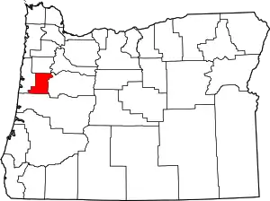 Benton County map | |
| CDPs | ||
| Other unincorporated communities | ||
| Footnotes | ‡This populated place also has portions in an adjacent county or counties | |
| ||