Philomath, Oregon
Philomath (/fɪˈloʊməθ/ fi-LOH-məth) is a city in Benton County, Oregon, United States. It was named for Philomath (Greek, "love of learning") College. The population was 4,584 at the 2010 census and was most recently estimated in 2019 to have a population of 5,666. It is part of the Corvallis, Oregon, Metropolitan Statistical Area.
Philomath, Oregon | |
|---|---|
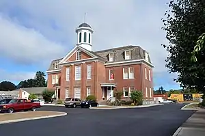 Benton County Historical Museum in Philomath | |
| Nickname(s): City of Volunteers | |
 Location in Oregon | |
| Coordinates: 44°32′26″N 123°21′46″W | |
| Country | United States |
| State | Oregon |
| County | Benton |
| Incorporated | 1882 |
| Government | |
| • Body | Philomath City Council |
| • Mayor | Eric Niemann |
| Area | |
| • Total | 2.21 sq mi (5.73 km2) |
| • Land | 2.02 sq mi (5.24 km2) |
| • Water | 0.19 sq mi (0.49 km2) |
| Elevation | 279 ft (85.0 m) |
| Population | |
| • Total | 4,584 |
| • Estimate (2019)[3] | 5,666 |
| • Density | 2,802.18/sq mi (1,081.91/km2) |
| Time zone | UTC-8 (Pacific) |
| • Summer (DST) | UTC-7 (Pacific) |
| ZIP code | 97370 |
| Area code(s) | 541 |
| FIPS code | 41-57450[2] |
| GNIS feature ID | 1147639[4] |
| Website | www.ci.philomath.or.us |
History
Philomath was named after the Philomath College [5] that was founded in 1867 by the United Brethren Church. The name of the college and city was derived from two Greek words meaning "lover of learning". The city was incorporated on October 20, 1882. The college closed in 1929 due to a dramatic decline in enrollment.[6]
Geography
Philomath is 5 miles (8 km) west of Corvallis on U.S. Route 20.
According to the United States Census Bureau, the city has a total area of 2.05 square miles (5.31 km2), of which 1.86 square miles (4.82 km2) is land and 0.19 square miles (0.49 km2) is water.[7]
Climate
This region experiences warm (but not hot) and dry summers, with no average monthly temperatures above 71.6 °F (22.0 °C). According to the Köppen Climate Classification system, Philomath has a warm-summer Mediterranean climate, abbreviated "Csb" on climate maps.[8]
Demographics
| Historical population | |||
|---|---|---|---|
| Census | Pop. | %± | |
| 1880 | 224 | — | |
| 1900 | 343 | — | |
| 1910 | 505 | 47.2% | |
| 1920 | 591 | 17.0% | |
| 1930 | 694 | 17.4% | |
| 1940 | 856 | 23.3% | |
| 1950 | 1,289 | 50.6% | |
| 1960 | 1,359 | 5.4% | |
| 1970 | 1,688 | 24.2% | |
| 1980 | 2,673 | 58.4% | |
| 1990 | 2,983 | 11.6% | |
| 2000 | 4,056 | 36.0% | |
| 2010 | 4,584 | 13.0% | |
| 2019 (est.) | 5,666 | [3] | 23.6% |
| U.S. Decennial Census[9] | |||
2010 census
As of the census of 2010, there were 4,584 people, 1,733 households, and 1,203 families living in the city. The population density was 2,464.5 inhabitants per square mile (951.5/km2). There were 1,837 housing units at an average density of 987.6 per square mile (381.3/km2). The racial makeup of the city was 91.1% White, 0.7% African American, 1.2% Native American, 1.0% Asian, 2.4% from other races, and 3.7% from two or more races. Hispanic or Latino of any race were 6.7% of the population.[2]
There were 1,733 households, of which 38.2% had children under the age of 18 living with them, 51.7% were married couples living together, 14.0% had a female householder with no husband present, 3.8% had a male householder with no wife present, and 30.6% were non-families. 23.4% of all households were made up of individuals, and 5.9% had someone living alone who was 65 years of age or older. The average household size was 2.64 and the average family size was 3.11.[2]
The median age in the city was 34.3 years. 27.9% of residents were under the age of 18; 9.2% were between the ages of 18 and 24; 27.2% were from 25 to 44; 26.3% were from 45 to 64; and 9.4% were 65 years of age or older. The gender makeup of the city was 47.8% male and 52.2% female.[2]
2000 census
As of the census of 2000, there were 3,838 people, 1,346 households, and 1,017 families living in the city. The population density was 2,993.0 people per square mile (1,157.7/km2). There were 1,434 housing units at an average density of 1,118.3 per square mile (432.6/km2). The racial makeup of the city was 93.25% White, 0.16% African American, 1.64% Native American, 1.20% Asian, 0.23% Pacific Islander, 1.25% from other races, and 2.27% from two or more races. Hispanic or Latino of any race were 3.93% of the population.[2]
There were 1,346 households, out of which 47.3% had children under the age of 18 living with them, 55.8% were married couples living together, 15.1% had a female householder with no husband present, and 24.4% were non-families. 18.6% of all households were made up of individuals, and 5.1% had someone living alone who was 65 years of age or older. The average household size was 2.85 and the average family size was 3.22.[2]
In the city, the population was spread out, with 34.3% under the age of 18, 7.1% from 18 to 24, 32.1% from 25 to 44, 19.6% from 45 to 64, and 6.9% who were 65 years of age or older. The median age was 32 years. For every 100 females, there were 98.9 males. For every 100 females age 18 and over, there were 95.2 males.[2]
The median income for a household in the city was $41,461, and the median income for a family was $42,578. Males had a median income of $36,104 versus $25,281 for females. The per capita income for the city was $16,620. About 6.5% of families and 8.2% of the population were below the poverty line, including 9.2% of those under age 18 and 10.2% of those aged 65 or over.[2]
Economy
Philomath is home to several sawmills including Georgia-Pacific and Paw Lumber Co. Gene Tools, LLC manufactures Morpholino antisense oligonucleotides. Wet Labs produces oceanographic measuring equipment. Alyrica Networks provides WiFi access in the town, as well as fixed wireless high-speed Internet service. Solar Summit manufactures solar panels and alternative energy products. Pioneer provides telephone service. Gathering Together Farm is one of the first certified organic vegetable farms in the United States, and is an international agrotourism destination.
Education
Philomath is served by the Philomath School District,[10] which includes the following schools:
- Philomath Elementary School
- Clemens Primary School
- Philomath Middle School
- Philomath High School
- Kings Valley Charter School (Pre-K through 12th grade)
Mass media
The Philomath News is a digital newspaper owned by Brad Fuqua, former editor of the Philomath Express, which was shut down by Lee Enterprises in September 2020. The Philomath News launched on Nov. 30, 2020, and depends on voluntary memberships and digital advertising for revenue.
Documentary
The film Clear Cut: The Story of Philomath, Oregon documents the clash of cultures in Philomath between the old-time timber industry and the professionals and techies of the information age. The film was shown in the Sundance Film Festival in 2006.
References
- "2019 U.S. Gazetteer Files". United States Census Bureau. Retrieved July 28, 2020.
- "U.S. Census website". United States Census Bureau. Retrieved 2012-12-21.
- "Population and Housing Unit Estimates". United States Census Bureau. May 24, 2020. Retrieved May 27, 2020.
- "US Board on Geographic Names". United States Geological Survey. 2007-10-25. Retrieved 2008-01-31.
- "Philomath College". THe Benton County Historical Society. Retrieved 2017-06-23.
- Robbins, William G. "Philomath". The Oregon Encyclopedia. Portland State University. Retrieved 2013-04-05.
- "US Gazetteer files 2010". United States Census Bureau. Archived from the original on 2012-07-02. Retrieved 2012-12-21.
- "Philomath, Oregon". Weatherbase. CantyMedia. 2015. Retrieved 2015-04-08.
- "Census of Population and Housing". Census.gov. Retrieved June 4, 2015.
- "Philomath School District". Philomath School District. 2013. Retrieved 2015-04-08.
External links
- Entry for Philomath in the Oregon Blue Book
- "Philomath". The Oregon Encyclopedia.
- Philomath Area Chamber of Commerce
- Historic images of Philomath from Salem Public Library
- Philomath Community Wiki
Municipalities and communities of Benton County, Oregon, United States | ||
|---|---|---|
| Cities | 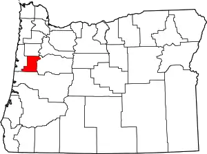 Benton County map | |
| CDPs | ||
| Other unincorporated communities | ||
| Footnotes | ‡This populated place also has portions in an adjacent county or counties | |
| ||
| Authority control |
|---|
