Alvarado, Indiana
Alvarado is an unincorporated community in Richland Township, Steuben County, in the U.S. state of Indiana.[2]
Alvarado, Indiana | |
|---|---|
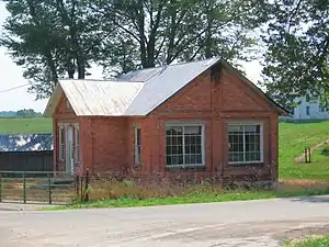 An old brick house in Alvarado | |
 Alvarado  Alvarado | |
| Coordinates: 41°34′24″N 84°50′12″W | |
| Country | United States |
| State | Indiana |
| County | Steuben |
| Township | Richland |
| Elevation | 961 ft (293 m) |
| Time zone | UTC-5 (Eastern (EST)) |
| • Summer (DST) | UTC-4 (EDT) |
| ZIP code | 46742 |
| Area code(s) | 260 |
| GNIS feature ID | 430126 |
History
A post office was established at Alvarado in 1855, and remained in operation until 1904.[3] An old variant name of the community was called Richland Center.[4]
In 1849, the Alvarado United Methodist Church was built, and is still in service today.[5]
Geography
Alvarado is located at 41°34′24″N 84°50′12″W.
References
- "US Board on Geographic Names". United States Geological Survey. October 25, 2007. Retrieved 2016-10-03.
- "Alvarado, Indiana". Geographic Names Information System. United States Geological Survey. Retrieved August 2, 2017.
- "Steuben County". Jim Forte Postal History. Retrieved October 3, 2016.
- "USGS detail on Alvarado - Variant Citation". Retrieved 2016-10-03.
- "Alvarado United Methodist Church". Alvarado United Methodist Church. Retrieved June 6, 2018.
Municipalities and communities of Steuben County, Indiana, United States | ||
|---|---|---|
| City | Map of Indiana highlighting Steuben County | |
| Towns | ||
| Townships | ||
| Unincorporated communities |
| |
| Footnotes | ‡This populated place also has portions in an adjacent county or counties | |
| ||
This article is issued from Wikipedia. The text is licensed under Creative Commons - Attribution - Sharealike. Additional terms may apply for the media files.