Angola, Indiana
Angola is a city in Pleasant Township, Steuben County, Indiana, United States. The population was 8,612 at the 2010 census. The city is the county seat of Steuben County.[7] Angola was founded by Thomas Gale and Cornelius Gilmore on June 28, 1838, and is home to Trine University. The town is served by I-69 and the Indiana Toll Road (I-80 and I-90).
Angola | |
|---|---|
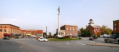
 Downtown Angola's traffic circle, "the Mound", with a Civil War monument. The building with the cupola is the county courthouse. | |
| Motto(s): "Proud of our past. Planning for our future." | |
 Location of Angola in Steuben County, Indiana. | |
 Angola Location of Angola in Steuben County, Indiana.  Angola Angola (the United States)  Angola Angola (North America) | |
| Coordinates: 41°38′13″N 85°0′3″W | |
| Country | United States |
| State | Indiana |
| County | Steuben |
| Township | Pleasant |
| Government | |
| • Mayor | Richard "Dick" Hickman (D) |
| Area | |
| • Total | 6.54 sq mi (16.94 km2) |
| • Land | 6.49 sq mi (16.82 km2) |
| • Water | 0.05 sq mi (0.12 km2) |
| Elevation | 1,063 ft (324 m) |
| Population | |
| • Total | 8,612 |
| • Estimate (2019)[4] | 8,732 |
| • Density | 1,345.04/sq mi (519.29/km2) |
| Time zone | UTC-5 (EST) |
| • Summer (DST) | UTC-4 (EDT) |
| ZIP code | 46703 |
| Area code | 260 |
| FIPS code[2][5] | 18-01666 |
| GNIS ID[2][5] | 430179 |
| Website | www |
| Historical population | |||
|---|---|---|---|
| Census | Pop. | %± | |
| 1850 | 226 | — | |
| 1870 | 1,072 | — | |
| 1880 | 1,280 | 19.4% | |
| 1890 | 1,840 | 43.8% | |
| 1900 | 2,141 | 16.4% | |
| 1910 | 2,610 | 21.9% | |
| 1920 | 2,650 | 1.5% | |
| 1930 | 2,665 | 0.6% | |
| 1940 | 3,141 | 17.9% | |
| 1950 | 5,081 | 61.8% | |
| 1960 | 4,746 | −6.6% | |
| 1970 | 5,117 | 7.8% | |
| 1980 | 5,486 | 7.2% | |
| 1990 | 5,824 | 6.2% | |
| 2000 | 7,344 | 26.1% | |
| 2010 | 8,612 | 17.3% | |
| 2019 (est.) | 8,732 | [4] | 1.4% |
| U.S. Decennial Census[6] | |||
History
The Angola post office has been in operation since 1838.[8]
Some of the first settlers came from Angola, New York, and they named their new home after their old one.[9]
The Angola Commercial Historic District, Steuben County Courthouse, and Steuben County Jail are listed on the National Register of Historic Places.[10][11]
Geography
The center of Angola is located at 41°38′13″N 85°0′3″W, the intersection of U.S. 20 and State Road 127. The roads are known to the citizens of Angola as North and South Wayne street and West and East Maumee street.
According to the 2010 census, Angola has a total area of 6.387 square miles (16.54 km2), of which 6.34 square miles (16.42 km2) (or 99.26%) is land and 0.047 square miles (0.12 km2) (or 0.74%) is water.[12]
Climate
The National Weather Service reports that Angola's average January temperatures are a maximum of 28.8 °F (−1.8 °C) and a minimum of 13.7 °F (−10.2 °C). Average July temperatures are a maximum of 82.0 °F (27.8 °C) and a minimum of 60.4 °F (15.8 °C). There are an average of 7.5 days with highs of 90 °F (32 °C) or higher. There an average of 28.1 days with highs of 32 °F (0 °C) or lower and an average of 2.3 days with lows of 0 °F (−18 °C) or lower. The record high temperature was 106 °F (41 °C) on July 13, 1936. The record low temperature was −27 °F (−33 °C) on January 4, 1981.
The average annual precipitation is 37.27 inches (947 mm). There are an average of 119.4 days with measurable precipitation. The wettest year was 1950, with 52.48 inches (1,333 mm) and the driest was 1971, with 24.07 inches (611 mm). The most precipitation in one month was 12.23 inches (311 mm) in May 1943. The most precipitation in a 24-hour period was 5.00 inches (127 mm) on July 9, 1951.
The average annual snowfall is 34.7 inches (880 mm). There are an average of 22.0 days with measurable snowfall. The snowiest season was 1981–82 with 74.9 inches (1,900 mm). The most snowfall in one month was 31.5 inches (800 mm) in January 1999, including the record 24-hour snowfall of 14.3 inches (360 mm) on January 3, 1999.[13]
| Climate data for Angola, Indiana | |||||||||||||
|---|---|---|---|---|---|---|---|---|---|---|---|---|---|
| Month | Jan | Feb | Mar | Apr | May | Jun | Jul | Aug | Sep | Oct | Nov | Dec | Year |
| Average high °F (°C) | 31.0 (−0.6) |
33.2 (0.7) |
43.7 (6.5) |
57.4 (14.1) |
69.3 (20.7) |
78.8 (26.0) |
83.0 (28.3) |
81.1 (27.3) |
74.4 (23.6) |
62.3 (16.8) |
47.1 (8.4) |
34.5 (1.4) |
58.0 (14.4) |
| Average low °F (°C) | 15.9 (−8.9) |
16.5 (−8.6) |
25.4 (−3.7) |
36.5 (2.5) |
47.3 (8.5) |
57.3 (14.1) |
61.3 (16.3) |
59.5 (15.3) |
52.4 (11.3) |
41.4 (5.2) |
30.9 (−0.6) |
20.5 (−6.4) |
38.7 (3.8) |
| Average precipitation inches (mm) | 2.2 (56) |
2.0 (51) |
2.8 (71) |
3.5 (89) |
3.8 (97) |
3.7 (94) |
3.7 (94) |
3.5 (89) |
3.2 (81) |
2.8 (71) |
2.9 (74) |
2.6 (66) |
36.6 (930) |
| Source: Weatherbase[14] | |||||||||||||

Demographics
2010 census
As of the 2010 census,[3] there were 8,612 people, 3,111 households, and 1,815 families living in the city. The population density was 1,358.4 inhabitants per square mile (524.5/km2). There were 3,499 housing units at an average density of 551.9 per square mile (213.1/km2). The racial makeup of the city was 93.6% White, 1.4% African American, 0.3% Native American, 0.8% Asian, 0.1% Pacific Islander, 2.1% from other races, and 1.7% from two or more races. Hispanic or Latino of any race were 6.3% of the population.
There were 3,111 households, which 32.0% had children under the age of 18 living with them, 38.7% were married couples living together, 14.3% had a female householder with no husband present, 5.4% had a male householder with no wife present, and 41.7% were non-families. 33.1% of all households were made up of individuals, and 12.2% had someone living alone who was 65 years of age or older. The average household size was 2.35 and the average family size was 2.99.
The median age in the city was 30.3 years. 22.1% of residents were under the age of 18; 21.2% were between the ages of 18 and 24; 24% were from 25 to 44; 19.6% were from 45 to 64; and 13% were 65 years of age or older. The gender makeup of the city was 50.6% male and 49.4% female.
2000 census
As of the 2000 census,[15] there were 7,344 people, 2,769 households, and 1,578 families living in the city. The population density was 1,736.4 people per square mile (670.3/km2). There were 3,012 housing units at an average density of 712.1 per square mile (274.9/km2). The racial makeup of the city was 94.00% White, 0.82% African American, 0.44% Native American, 1.23% Asian, 0.04% Pacific Islander, 1.92% from other races, and 1.57% from two or more races. Hispanic or Latino of any race were 3.89% of the population.
There were 2,769 households, out of which 30.4% had children under the age of 18 living with them, 41.0% were married couples living together, 11.8% had a female householder with no husband present, and 43.0% were non-families. 34.2% of all households were made up of individuals, and 13.5% had someone living alone who was 65 years of age or older. The average household size was 2.32 and the average family size was 2.99.
In the city, the population was spread out, with 22.7% under the age of 18, 20.7% from 18 to 24, 26.7% from 25 to 44, 17.0% from 45 to 64, and 12.9% who were 65 years of age or older. The median age was 29 years. For every 100 females, there were 105.8 males. For every 100 females age 18 and over, there were 107.3 males.
The median income for a household in the city was $34,925, and the median income for a family was $43,848. Males had a median income of $32,031 versus $23,258 for females. The per capita income for the city was $16,750. About 8.1% of families and 10.5% of the population were below the poverty line, including 6.5% of those under age 18 and 13.2% of those age 65 or over.
Media
Radio stations
- 100.3 WLKI-FM wlki
- 92.7 ESPN Angola
- 101.3 U-Rock
Television stations
- 63 WINM
Newspapers
The Herald Republican, the daily newspaper based in Angola and serving Steuben County, was formed through the merger of two longstanding weekly newspapers in Angola, the Steuben Republican (first published in May 1857) and The Angola Herald (January 1876). The newspapers consolidated their printing plants in 1925 and their ownership in the 1960s (in the Willis family), eventually merging into one publication in 1980. Two years later they were sold to Home News Enterprises, which expanded the paper to a twice-weekly format in 1989, and then in August 2001 to KPC Media Group of Kendallville, Indiana, which converted The Herald Republican to a daily in September 2001.[16]
Education
The Metropolitan School District of Steuben County, which operates the following schools in Angola:[17]
- Carlin Park Elementary
- Hendry Park Elementary
- Ryan Park Elementary
- Pleasant Lake Elementary
- Angola Middle School
- Angola High School
- Educational Opportunity Center

Angola has a lending library: the Carnegie Public Library of Steuben Co.[18]
Notable people
- Lloy Ball, Olympic volleyball gold medalist
- John Barnes, science-fiction writer[19]
- Brian Cardinal, NBA basketball player
- Hagood Hardy, 1937–1997, Canadian-American jazz musician and composer
- Lewis Blaine Hershey, 1893–1977, U.S. Army four-star general, second Director of the Selective Service
- Lois Irene Marshall, 1873–1958, wife of U.S. Vice President Thomas R. Marshall
- Edward Ralph May, 1819–1852, the only member of the Indiana Constitutional Convention of 1850 to vote for African American suffrage, practiced law in Angola from 1843 to 1852
- Wilbur Simpson, classical bassoonist
- Raymond E. Willis, U.S. Senator
- J. Walter Yeagley, former judge of the District of Columbia Court of Appeals
See also
References
- "2019 U.S. Gazetteer Files". United States Census Bureau. Retrieved July 16, 2020.
- "Feature ID 430179". Geographic Names Information System. United States Geological Survey. Retrieved June 30, 2014.
- "U.S. Census website". United States Census Bureau. Retrieved 2012-12-11.
- "Population and Housing Unit Estimates". United States Census Bureau. May 24, 2020. Retrieved May 27, 2020.
- "FIPS55 Data: Indiana". FIPS55 Data. United States Geological Survey. February 23, 2006. Archived from the original on June 18, 2006. Retrieved June 30, 2014.
- "Census of Population and Housing". Census.gov. Retrieved June 4, 2015.
- "Find a County". National Association of Counties. Archived from the original on 2011-05-31. Retrieved 2011-06-07.
- "Steuben County". Jim Forte Postal History. Retrieved September 28, 2016.
- Rose, Gregory Steven (1981). The Southern-ness of Hoosierdom. Michigan State University. p. 253.
names which had been transferred from other states were mapped, as were places originally settled by people from a certain state. As examples, Angola, Indiana, was "named for Angola, New York, home of settlers"
- "National Register Information System". National Register of Historic Places. National Park Service. July 9, 2010.
- "National Register of Historic Places Listings". Weekly List of Actions Taken on Properties: 12/27/10 through 12/30/10. National Park Service. 2011-01-07.
- "G001 - Geographic Identifiers - 2010 Census Summary File 1". United States Census Bureau. Archived from the original on 2020-02-13. Retrieved 2015-07-28.
- http://mcc.sws.uiuc.edu/climate_midwest/mwclimate_data_summaries.htm#%5B%5D
- "Weatherbase: Historical Weather for Angola, Indiana". Weatherbase. 2011. Retrieved on November 24, 2011.
- "U.S. Census website". United States Census Bureau. Retrieved 2008-01-31.
- "About Us — KPC Media Group Inc". KPCNews.com. Retrieved June 20, 2012.
- "Welcome to MSD of Steuben County!". msdsteuben.k12.in.us. Retrieved 29 June 2016.
- "Indiana public library directory" (PDF). Indiana State Library. Retrieved 15 March 2018.
- "Authors : Barnes, John : SFE : Science Fiction Encyclopedia". sf-encyclopedia.com. Retrieved 7 June 2015.
External links
| Wikivoyage has a travel guide for Angola (Indiana). |