Anabarsky District
Anabarsky District (Russian: Анаба́рский улу́с; Yakut: Анаабыр улууһа, Anaabır uluuha, IPA: [anaːbɯɾ uluːha]) is an administrative[1] and municipal[5] district (raion, or ulus), one of the thirty-four in the Sakha Republic, Russia. It is located in the northwest of the republic and borders with Bulunsky District in the east, Olenyoksky District in the south, and with Taymyrsky Dolgano-Nenetsky District of Krasnoyarsk Krai in the west. The area of the district is 55,600 square kilometers (21,500 sq mi).[2] Its administrative center is the rural locality (a selo) of Saskylakh.[2] As of the 2010 Census, the total population of the district was 3,501, with the population of Saskylakh accounting for 66.2% of that number.[3]
Anabarsky District
Анабарский улус | |
|---|---|
| Other transcription(s) | |
| • Yakut | Анаабыр улууhа |
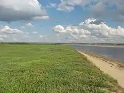 Anabar River, Anabarsky District | |
 Flag .png.webp) Coat of arms | |
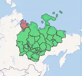
Location of Anabarsky District in the Sakha Republic | |
| Coordinates: 72°07′N 114°21′E | |
| Country | Russia |
| Federal subject | Sakha Republic[1] |
| Established | December 30, 1930[2] |
| Administrative center | Saskylakh[2] |
| Area | |
| • Total | 55,600 km2 (21,500 sq mi) |
| Population | |
| • Total | 3,501 |
| • Estimate (2018)[4] | 3,567 (+1.9%) |
| • Density | 0.063/km2 (0.16/sq mi) |
| • Urban | 0% |
| • Rural | 100% |
| Administrative structure | |
| • Administrative divisions | 3 Rural okrugs |
| • Inhabited localities[2] | 3 Rural localities |
| Municipal structure | |
| • Municipally incorporated as | Anabarsky Municipal District[5] |
| • Municipal divisions[6] | 0 Urban settlements, 2 Rural settlements |
| Time zone | UTC+9 (MSK+6 |
| OKTMO ID | 98610000 |
| 2010 Census | 3,501[3] |
|---|---|
| 2002 Census | 4,024[8] |
| 1989 Census | 3,903[9] |
| 1979 Census | 2,161[10] |
Geography
The district is washed by the Laptev Sea in the north. The landscape of the district is mostly flat. The main river is the Anabar and the largest lake is Lake Sappyya.
Climate
Average January temperature ranges from −34 to −36 °C (−29 to −33 °F) and average July temperature ranges from +4 to +10 °C (39 to 50 °F). Average annual precipitation is 150–200 millimeters (5.9–7.9 in).
History
The district was established on December 30, 1930.[2]
Administrative and municipal status
Within the framework of administrative divisions, Anabarsky District is one of the thirty-four in the republic.[1] The district is divided into three rural okrugs (naslegs) which comprise three rural localities.[2] As a municipal division, the district is incorporated as Anabarsky Municipal District.[5] Its three rural okrugs are incorporated into two rural settlements within the municipal district.[6] The selo of Saskylakh serves as the administrative center of both the administrative[2] and municipal[5] district.
Inhabited localities
| Rural okrugs/Rural settlements | Population[3] | Rural localities in jurisdiction* |
|---|---|---|
| Saskylakhsky Rural Okrug/Rural Settlement (Саскылахский) |
2,317 |
|
| Ebelyakhsky Rural Okrug (Эбеляхский) |
36 |
|
| Yuryung-Khainsky Rural Okrug/Rural Settlement (Юрюнг-Хаинский) |
1,148 |
|
*Administrative centers are shown in bold
Economy
The economy of the district is mostly based on mining, reindeer husbandry, fishing, and hunting. There are deposits of diamonds in the district.
Demographics
As of the 2010 Census, the ethnic composition was as follows:
The village of Yuryung-Khaya is the only settlement in the Sakha Republic where Dolgans form a majority of the population.
References
Notes
- Constitution of the Sakha Republic, Article 45
- Registry of the Administrative-Territorial Divisions of the Sakha Republic
- Russian Federal State Statistics Service (2011). "Всероссийская перепись населения 2010 года. Том 1" [2010 All-Russian Population Census, vol. 1]. Всероссийская перепись населения 2010 года [2010 All-Russia Population Census] (in Russian). Federal State Statistics Service.
- "26. Численность постоянного населения Российской Федерации по муниципальным образованиям на 1 января 2018 года". Federal State Statistics Service. Retrieved January 23, 2019.
- Law #172-Z #351-III
- Law #173-Z #354-III
- "Об исчислении времени". Официальный интернет-портал правовой информации (in Russian). June 3, 2011. Retrieved January 19, 2019.
- Russian Federal State Statistics Service (May 21, 2004). "Численность населения России, субъектов Российской Федерации в составе федеральных округов, районов, городских поселений, сельских населённых пунктов – районных центров и сельских населённых пунктов с населением 3 тысячи и более человек" [Population of Russia, Its Federal Districts, Federal Subjects, Districts, Urban Localities, Rural Localities—Administrative Centers, and Rural Localities with Population of Over 3,000] (XLS). Всероссийская перепись населения 2002 года [All-Russia Population Census of 2002] (in Russian).
- "Всесоюзная перепись населения 1989 г. Численность наличного населения союзных и автономных республик, автономных областей и округов, краёв, областей, районов, городских поселений и сёл-райцентров" [All Union Population Census of 1989: Present Population of Union and Autonomous Republics, Autonomous Oblasts and Okrugs, Krais, Oblasts, Districts, Urban Settlements, and Villages Serving as District Administrative Centers]. Всесоюзная перепись населения 1989 года [All-Union Population Census of 1989] (in Russian). Институт демографии Национального исследовательского университета: Высшая школа экономики [Institute of Demography at the National Research University: Higher School of Economics]. 1989 – via Demoscope Weekly.
- "Всесоюзная перепись населения 1979 г. Национальный состав населения по регионам России" [All Union Population Census of 1979. Ethnic composition of the population by regions of Russia] (XLS). Всесоюзная перепись населения 1979 года [All-Union Population Census of 1979] (in Russian). 1979 – via Demoscope Weekly (website of the Institute of Demographics of the State University—Higher School of Economics.
Sources
- Official website of the Sakha Republic. Registry of the Administrative-Territorial Divisions of the Sakha Republic. Anabarsky District. (in Russian)
- Верховный Совет Республики Саха (Якутия). 4 апреля 1992 г. «Конституция (основной закон) Республики Саха (Якутия)», в ред. Конституционного закона №1077-З №1035-IV от 8 июня 2012 г. «О внесении изменений и дополнений в Конституцию (основной закон) Республики Саха (Якутия)». Опубликован: "Якутские ведомости", №7, 26 апреля 1992 г. (Supreme Council of the Sakha (Yakutia) Republic. April 4, 1992 Constitution (Basic Law) of the Sakha (Yakutia) Republic, as amended by the Constitutional Law #1077-Z No. 1035-IV of June 8, 2012 On Amending and Supplementing the Constitution (Basic Law) of the Sakha (Yakutia) Republic. ).
- Государственное Собрание (Ил Тумэн) Республики Саха (Якутия). Закон №172-З №351-III от 30 ноября 2004 г. «Об установлении границ и о наделении статусом муниципального района муниципальных образований Республики Саха (Якутия)», в ред. Закона №1535-З №597-V от 27 ноября 2015 г. «О внесении изменений в статьи 1 и 2 Закона Республики Саха (Якутия) "Об установлении границ и о наделении статусом муниципального района муниципальных образований Республики Саха (Якутия)"». Вступил в силу со дня официального опубликования. Опубликован: "Якутия", №245, 31 декабря 2004 г. (State Assembly (Il Tumen) of the Sakha (Yakutia) Republic. Law #172-Z No. 351-III of November 30, 2004 On Establishing the Borders and on Granting the Municipal District Status to the Municipal Formations of the Sakha (Yakutia) Republic, as amended by the Law #1535-Z No. 597-V of November 27, 2015 On Amending Articles 1 and 2 of the Law of the Sakha (Yakutia) Republic "On Establishing the Borders and on Granting the Municipal District Status to the Municipal Formations of the Sakha (Yakutia) Republic". Effective as of the day of the official publication.).
- Государственное Собрание (Ил Тумэн) Республики Саха (Якутия). Закон №173-З №353-III от 30 ноября 2004 г. «Об установлении границ и о наделении статусом городского и сельского поселений муниципальных образований Республики Саха (Якутия)», в ред. Закона №1058-З №1007-IV от 25 апреля 2012 г. «О внесении изменений в Закон Республики Саха (Якутия) "Об установлении границ и о наделении статусом городского и сельского поселений муниципальных образований Республики Саха (Якутия)"». Вступил в силу со дня официального опубликования. Опубликован: "Якутия", №245, 31 декабря 2004 г. (State Assembly (Il Tumen) of the Sakha (Yakutia) Republic. Law #173-Z No. 353-III of November 30, 2004 On Establishing the Borders and on Granting the Urban and Rural Settlement Status to the Municipal Formations of the Sakha (Yakutia) Republic, as amended by the Law #1058-Z No. 1007-IV of April 25, 2012 On Amending the Law of the Sakha (Yakutia) Republic "On Establishing the Borders and on Granting the Urban and Rural Settlement Status to the Municipal Formations of the Sakha (Yakutia) Republic". Effective as of the day of the official publication.).
