Zhigansky District
Zhigansky District (Russian: Жига́нский улу́с; Yakut: Эдьигээн улууһа) is an administrative[1] and municipal[6] district (raion, or ulus), one of the thirty-four in the Sakha Republic, Russia. It is located in the northern central part of the republic and borders with Bulunsky District in the north, Eveno-Bytantaysky National District in the east, Kobyaysky District in the southeast, Vilyuysky District in the southwest, and with Olenyoksky District in the northwest. The area of the district is 140,200 square kilometers (54,100 sq mi).[3] Its administrative center is the rural locality (a selo) of Zhigansk.[3] Population: 4,296 (2010 Census);[4] 4,312 (2002 Census);[9] 5,678 (1989 Census).[10] The population of Zhigansk accounts for 79.6% of the district's total population.[4]
Zhigansky District
Жиганский улус | |
|---|---|
| Other transcription(s) | |
| • Sakha | Эдьигээн улууhа |
 Northern noon, Zhigansky District | |
.svg.png.webp) Flag .png.webp) Coat of arms | |
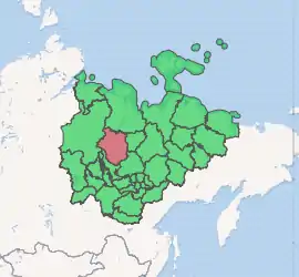
Location of Zhigansky District in the Sakha Republic | |
| Coordinates: 66°46′N 123°16′E | |
| Country | Russia |
| Federal subject | Sakha Republic[1] |
| Established | December 10, 1930[2] |
| Administrative center | Zhigansk[3] |
| Area | |
| • Total | 140,200 km2 (54,100 sq mi) |
| Population | |
| • Total | 4,296 |
| • Estimate (2018)[5] | 4,222 (−1.7%) |
| • Density | 0.031/km2 (0.079/sq mi) |
| • Urban | 0% |
| • Rural | 100% |
| Administrative structure | |
| • Administrative divisions | 4 rural okrug |
| • Inhabited localities[3] | 5 Rural localities |
| Municipal structure | |
| • Municipally incorporated as | Zhigansky Municipal District[6] |
| • Municipal divisions[7] | 0 Urban settlements, 4 Rural settlements |
| Time zone | UTC+9 (MSK+6 |
| OKTMO ID | 98622000 |
| Website | https://mr-zhiganskij.sakha.gov.ru/ |
Geography
The main river in the district is the Lena. The Muna River, one of its important tributaries, has its mouth in the district. The largest lake is Lake Ulakhan-Kyuyol.
Climate
Average January temperature ranges from −36 °C (−33 °F) in the east to −40 °C (−40 °F) in the west and average July temperature ranges from +14 °C (57 °F) to +16 °C (61 °F). Annual precipitation ranges from 250–300 millimeters (9.8–11.8 in) in the west to 300–400 millimeters (12–16 in) in the east.[2]
History
The district was established on December 10, 1930.[2]
Demographics
As of the 1989 Census, the ethnic composition was as follows:[2]
Inhabited localities
| Rural settlements | Population | Male | Female | Rural localities in jurisdiction* |
|---|---|---|---|---|
| Bestyakhsky Nasleg (Бестяхский наслег) |
218 | 111 (50.9%) | 107 (49.1%) | |
| Zhigansky Evenk National Nasleg (Жиганский эвенкийский национальный наслег) |
3,421 | 1,631 (47.8%) | 1,785 (52.2%) |
|
| Kystatyam (Кыстатыам) |
397 | 202 (50.9%) | 195 (49.1%) |
|
| Lindinsky Nasleg (Линдинский наслег) |
260 | 131 (50.4%) | 129 (49.6%) |
|
Divisional source:[11]
Population source:[4]
*Administrative centers are shown in bold
Note: The figures given in the table above include 2010 census reports of one person (male) living in the intersettlement territory,[4] clarified in the regional census data as inhabiting Dzardzhan.[12]
References
Notes
- Constitution of the Sakha Republic
- Center of the Socioeconomic and Political Monitoring. Zhigansky District Archived September 21, 2012, at the Wayback Machine (in Russian)
- Registry of the Administrative-Territorial Divisions of the Sakha Republic
- Russian Federal State Statistics Service (2011). "Всероссийская перепись населения 2010 года. Том 1" [2010 All-Russian Population Census, vol. 1]. Всероссийская перепись населения 2010 года [2010 All-Russia Population Census] (in Russian). Federal State Statistics Service.
- "26. Численность постоянного населения Российской Федерации по муниципальным образованиям на 1 января 2018 года". Federal State Statistics Service. Retrieved January 23, 2019.
- Law #172-Z #351-III
- Law #173-Z #354-III
- "Об исчислении времени". Официальный интернет-портал правовой информации (in Russian). June 3, 2011. Retrieved January 19, 2019.
- Russian Federal State Statistics Service (May 21, 2004). "Численность населения России, субъектов Российской Федерации в составе федеральных округов, районов, городских поселений, сельских населённых пунктов – районных центров и сельских населённых пунктов с населением 3 тысячи и более человек" [Population of Russia, Its Federal Districts, Federal Subjects, Districts, Urban Localities, Rural Localities—Administrative Centers, and Rural Localities with Population of Over 3,000] (XLS). Всероссийская перепись населения 2002 года [All-Russia Population Census of 2002] (in Russian).
- "Всесоюзная перепись населения 1989 г. Численность наличного населения союзных и автономных республик, автономных областей и округов, краёв, областей, районов, городских поселений и сёл-райцентров" [All Union Population Census of 1989: Present Population of Union and Autonomous Republics, Autonomous Oblasts and Okrugs, Krais, Oblasts, Districts, Urban Settlements, and Villages Serving as District Administrative Centers]. Всесоюзная перепись населения 1989 года [All-Union Population Census of 1989] (in Russian). Институт демографии Национального исследовательского университета: Высшая школа экономики [Institute of Demography at the National Research University: Higher School of Economics]. 1989 – via Demoscope Weekly.
- Olenyoksy Ulus (Raion) Archived November 11, 2013, at the Wayback Machine Official website of the Sakha Republic
- Sakha Republic Territorial Branch of the Federal State Statistics Service. Results of the 2010 All-Russian Census. Численность населения по районам, городским и сельским населённым пунктам (Population Counts by Districts, Urban and Rural Inhabited Localities) (in Russian)
Sources
- Верховный Совет Республики Саха (Якутия). 4 апреля 1992 г. «Конституция (основной закон) Республики Саха (Якутия)», в ред. Конституционного закона №1077-З №1035-IV от 8 июня 2012 г. «О внесении изменений и дополнений в Конституцию (основной закон) Республики Саха (Якутия)». Опубликован: "Якутские ведомости", №7, 26 апреля 1992 г. (Supreme Council of the Sakha (Yakutia) Republic. April 4, 1992 Constitution (Basic Law) of the Sakha (Yakutia) Republic, as amended by the Constitutional Law #1077-Z No. 1035-IV of June 8, 2012 On Amending and Supplementing the Constitution (Basic Law) of the Sakha (Yakutia) Republic. ).
- Государственное Собрание (Ил Тумэн) Республики Саха (Якутия). Закон №172-З №351-III от 30 ноября 2004 г. «Об установлении границ и о наделении статусом муниципального района муниципальных образований Республики Саха (Якутия)», в ред. Закона №1535-З №597-V от 27 ноября 2015 г. «О внесении изменений в статьи 1 и 2 Закона Республики Саха (Якутия) "Об установлении границ и о наделении статусом муниципального района муниципальных образований Республики Саха (Якутия)"». Вступил в силу со дня официального опубликования. Опубликован: "Якутия", №245, 31 декабря 2004 г. (State Assembly (Il Tumen) of the Sakha (Yakutia) Republic. Law #172-Z No. 351-III of November 30, 2004 On Establishing the Borders and on Granting the Municipal District Status to the Municipal Formations of the Sakha (Yakutia) Republic, as amended by the Law #1535-Z No. 597-V of November 27, 2015 On Amending Articles 1 and 2 of the Law of the Sakha (Yakutia) Republic "On Establishing the Borders and on Granting the Municipal District Status to the Municipal Formations of the Sakha (Yakutia) Republic". Effective as of the day of the official publication.).
- Государственное Собрание (Ил Тумэн) Республики Саха (Якутия). Закон №173-З №353-III от 30 ноября 2004 г. «Об установлении границ и о наделении статусом городского и сельского поселений муниципальных образований Республики Саха (Якутия)», в ред. Закона №1058-З №1007-IV от 25 апреля 2012 г. «О внесении изменений в Закон Республики Саха (Якутия) "Об установлении границ и о наделении статусом городского и сельского поселений муниципальных образований Республики Саха (Якутия)"». Вступил в силу со дня официального опубликования. Опубликован: "Якутия", №245, 31 декабря 2004 г. (State Assembly (Il Tumen) of the Sakha (Yakutia) Republic. Law #173-Z No. 353-III of November 30, 2004 On Establishing the Borders and on Granting the Urban and Rural Settlement Status to the Municipal Formations of the Sakha (Yakutia) Republic, as amended by the Law #1058-Z No. 1007-IV of April 25, 2012 On Amending the Law of the Sakha (Yakutia) Republic "On Establishing the Borders and on Granting the Urban and Rural Settlement Status to the Municipal Formations of the Sakha (Yakutia) Republic". Effective as of the day of the official publication.).