Neryungrinsky District
Neryungrinsky District (Russian: Нерюнгри́нский улу́с; Yakut: Нүөрүҥгүрү улууһа, Nüörüñgürü uluuha, IPA: [nyøɾyŋgyɾy uluːha]) is an administrative[1] and municipal[7] district (raion, or ulus), one of the thirty-four in the Sakha Republic, Russia. It is the southernmost district of Sakha and borders Aldansky District in the north, Olyokminsky District in the west and northwest, Amur Oblast and a small area of Zabaykalsky Krai in the south, and Khabarovsk Krai in the east. The area of the district is 98,900 square kilometers (38,200 sq mi).[3] Its administrative center is the town of Neryungri.[3] Population (excluding the administrative center): 21,019 (2010 Census).[4]
Neryungrinsky District
Нерюнгринский улус | |
|---|---|
| Other transcription(s) | |
| • Sakha | Нүөрүҥгүрү улууhа |
 Neryungrinskiy | |
.png.webp) Flag .png.webp) Coat of arms | |
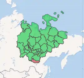
Location of Neryungrinsky District in the Sakha Republic | |
| Coordinates: 55.9°N 124.9°E | |
| Country | Russia |
| Federal subject | Sakha Republic[1] |
| Established | November 6, 1975[2] |
| Administrative center | Neryungri[3] |
| Area | |
| • Total | 98,900 km2 (38,200 sq mi) |
| Population | |
| • Total | 21,019 |
| • Estimate (2018)[5] | 73,987 (+252%) |
| • Density | 0.21/km2 (0.55/sq mi) |
| • Urban | 93.3% |
| • Rural | 6.7% |
| Administrative structure | |
| • Administrative divisions | 6 Settlements, 1 Rural okrugs |
| • Inhabited localities[3] | 1 Cities/towns, 6 Urban-type settlements[6], 2 Rural localities |
| Municipal structure | |
| • Municipally incorporated as | Neryungrinsky Municipal District[7] |
| • Municipal divisions[8] | 6 Urban settlements, 1 Rural settlements |
| Time zone | UTC+9 (MSK+6 |
| OKTMO ID | 98660000 |
| Website | http://www.neruadmin.ru/ |
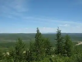
Geography
The landscape of the district is mostly mountainous. The main river in the district is the Aldan with its tributaries the Timpton and the Chulman. The largest lake is Lake Bolshoye Toko.
Climate
Average January temperature ranges from −30 °C (−22 °F) to −34 °C (−29 °F) and average July temperature ranges from +12 °C (54 °F) to +14 °C (57 °F).[2] Annual precipitation is 400–500 millimeters (16–20 in).[2]
History
The district was established on November 6, 1975.[2]
Demographics
As of the 1989 Census, the ethnic composition was as follows:[2]
Economy
There are deposits of gold, coal, iron ore, molybdenum, and construction materials in the district.
Administrative divisions
The district includes seven municipal divisions, covering a total of nine inhabited locations.
| Towns / Cities | Population | Male | Female | Inhabited localities in jurisdiction |
|---|---|---|---|---|
| Neryungri Urban Okrug (Нерюнгри) |
61,747 | 29,674 (48.1%) | 32,073 (51.9%) |
|
| Urban settlements | Population | Male | Female | Inhabited localities in jurisdiction |
| Berkakit Urban Okrug (Беркакит) |
4,291 | 2,036 (47.4%) | 2.255 (52.6%) | |
| Zolotinka Urban Okrug (Золотинка) |
620 | 304 (49.0%) | 316 (51.0%) | |
| Serebryany Bor Urban Okrug (Серебряный Бор) |
4,163 | 2,034 (48.9%) | 2,129 (51.1%) |
|
| Khani Urban Okrug (Хани) |
764 | 407 (53.3%) | 357 (46.7%) |
|
| Chulman Urban Okrug (Чульман) |
10,077 | 4,722 (46.9%) | 5,355 (53.2%) |
|
| Rural settlements | Population | Male | Female | Rural localities in jurisdiction* |
| Iyengirinsky Nasleg (Иенгринский) |
1,104 | 516 (46.7%) | 588 (53.3%) |
|
Divisional source:[10]
Population source:[4]
*Administrative centers are shown in bold
References
Notes
- Constitution of the Sakha Republic
- Center of the Socioeconomic and Political Monitoring. NeryungrinskyDistrict Archived September 21, 2012, at the Wayback Machine (in Russian)
- Registry of the Administrative-Territorial Divisions of the Sakha Republic
- Russian Federal State Statistics Service (2011). "Всероссийская перепись населения 2010 года. Том 1" [2010 All-Russian Population Census, vol. 1]. Всероссийская перепись населения 2010 года [2010 All-Russia Population Census] (in Russian). Federal State Statistics Service.
- "26. Численность постоянного населения Российской Федерации по муниципальным образованиям на 1 января 2018 года". Federal State Statistics Service. Retrieved January 23, 2019.
- The count of urban-type settlements may include the work settlements, the resort settlements, the suburban (dacha) settlements, as well as urban-type settlements proper.
- Law #172-Z #351-III
- Law #173-Z #354-III
- "Об исчислении времени". Официальный интернет-портал правовой информации (in Russian). June 3, 2011. Retrieved January 19, 2019.
- Neryungrinsky Ulus (Raion) Official website of the Sakha Republic
Sources
- Верховный Совет Республики Саха (Якутия). 4 апреля 1992 г. «Конституция (основной закон) Республики Саха (Якутия)», в ред. Конституционного закона №1077-З №1035-IV от 8 июня 2012 г. «О внесении изменений и дополнений в Конституцию (основной закон) Республики Саха (Якутия)». Опубликован: "Якутские ведомости", №7, 26 апреля 1992 г. (Supreme Council of the Sakha (Yakutia) Republic. April 4, 1992 Constitution (Basic Law) of the Sakha (Yakutia) Republic, as amended by the Constitutional Law #1077-Z No. 1035-IV of June 8, 2012 On Amending and Supplementing the Constitution (Basic Law) of the Sakha (Yakutia) Republic. ).
- Государственное Собрание (Ил Тумэн) Республики Саха (Якутия). Закон №172-З №351-III от 30 ноября 2004 г. «Об установлении границ и о наделении статусом муниципального района муниципальных образований Республики Саха (Якутия)», в ред. Закона №1535-З №597-V от 27 ноября 2015 г. «О внесении изменений в статьи 1 и 2 Закона Республики Саха (Якутия) "Об установлении границ и о наделении статусом муниципального района муниципальных образований Республики Саха (Якутия)"». Вступил в силу со дня официального опубликования. Опубликован: "Якутия", №245, 31 декабря 2004 г. (State Assembly (Il Tumen) of the Sakha (Yakutia) Republic. Law #172-Z No. 351-III of November 30, 2004 On Establishing the Borders and on Granting the Municipal District Status to the Municipal Formations of the Sakha (Yakutia) Republic, as amended by the Law #1535-Z No. 597-V of November 27, 2015 On Amending Articles 1 and 2 of the Law of the Sakha (Yakutia) Republic "On Establishing the Borders and on Granting the Municipal District Status to the Municipal Formations of the Sakha (Yakutia) Republic". Effective as of the day of the official publication.).
- Государственное Собрание (Ил Тумэн) Республики Саха (Якутия). Закон №173-З №353-III от 30 ноября 2004 г. «Об установлении границ и о наделении статусом городского и сельского поселений муниципальных образований Республики Саха (Якутия)», в ред. Закона №1058-З №1007-IV от 25 апреля 2012 г. «О внесении изменений в Закон Республики Саха (Якутия) "Об установлении границ и о наделении статусом городского и сельского поселений муниципальных образований Республики Саха (Якутия)"». Вступил в силу со дня официального опубликования. Опубликован: "Якутия", №245, 31 декабря 2004 г. (State Assembly (Il Tumen) of the Sakha (Yakutia) Republic. Law #173-Z No. 353-III of November 30, 2004 On Establishing the Borders and on Granting the Urban and Rural Settlement Status to the Municipal Formations of the Sakha (Yakutia) Republic, as amended by the Law #1058-Z No. 1007-IV of April 25, 2012 On Amending the Law of the Sakha (Yakutia) Republic "On Establishing the Borders and on Granting the Urban and Rural Settlement Status to the Municipal Formations of the Sakha (Yakutia) Republic". Effective as of the day of the official publication.).
| Authority control |
|
|---|