Arizona State Route 303
Arizona State Route 303, also known as Loop 303 (spoken as three-oh-three) Estrella Freeway and formerly Bob Stump Memorial Parkway is a freeway that serves the western portion of the Phoenix area. The freeway, originally a two-lane rural highway, was maintained by Maricopa County[2] in central Arizona serving the far western suburbs of the Phoenix metropolitan area until 2004 when the Arizona Department of Transportation again took control of upgrading the interim road to a freeway. In 2004, it was renamed "Bob Stump Memorial Parkway" to honor former Arizona congressman Bob Stump.[3] Its route runs from West Van Buren Street in Goodyear to Interstate 17 south of Carefree Highway. As of October 2017, Loop 303 is a full freeway from just south of I-10 to I-17.
| ||||
|---|---|---|---|---|
| Estrella Freeway | ||||
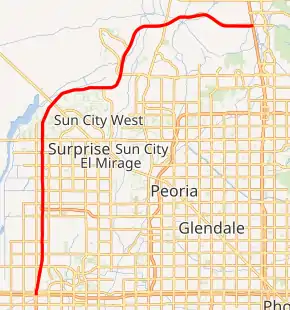
Loop 303 highlighted in red | ||||
| Route information | ||||
| Maintained by ADOT | ||||
| Length | 35.25 mi[1] (56.73 km) | |||
| Existed | 1991–present | |||
| History | Partially complete, under construction from 2013 until 2025 | |||
| Major junctions | ||||
| From | Van Buren Street in Goodyear | |||
| To | ||||
| Highway system | ||||
| ||||

Route description
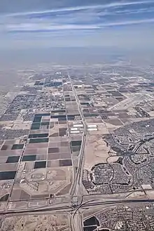
Loop 303 currently begins at Van Buren Street,[4] south of I-10 in Goodyear and at I-10 becomes a six-lane freeway with a stack interchange.[5] South of Van Buren Street it continues as Cotton Lane but without a route number. It heads north under McDowell and Thomas Roads, then over an interchange with Indian School Road. The road heads through a farmland terrain and passes the Wildlife World Zoo near Northern Avenue. It over passes a BNSF Railway spur line near Olive Avenue.[6] At an interchange with Greenway Road, Route 303 enters a residential community and turns northeast. The route heads over a bridge above Grand Avenue (US 60) along with another BNSF railroad line.[6] The route turns eastward and was recently upgraded to a six-lane freeway.[7] It turns north near the Happy Valley Parkway interchange and then east again south of Lake Pleasant, passing through planned arterial interchanges. The freeway comes to an end at a temporary at-grade interchange (eventually to be a stack interchange) with I-17 near Skunk Creek. East of this interchange, Route 303 becomes Sonoran Desert Drive. The south end from US 60 to I-10 is frequently used to bypass Grand Avenue and quickly move from Grand Avenue to Bell Road.[8]
History
Loop 303 was originally a part of the 1985 Maricopa County Regional Transportation Plan that was funded by a sales tax approved by Maricopa County voters. The freeway, designed to service the Northwest Valley, was originally designated SR 517 in 1985; the Loop 303 designation was first assigned on December 18, 1987.[9] The freeway was scheduled to be completed sometime by 2005. However, funding shortfalls and increasing construction costs forced cutbacks in the plan, and in 1995 the freeway was dropped from the regional plans.
Maricopa County took charge of what was then called the Estrella Freeway project when it was dropped from the regional freeway plans, maintaining it as an interim 2-lane highway along the original corridor while keeping the state route designation. The county then made significant improvements to the roadway, extending it several miles north and east of US 60. While the highway was still largely a 2-lane rural road, the extension north of US 60 along with the southern terminus just north of Interstate 10 was upgraded to a 4-lane divided parkway, and the segment between US 60 and Bell Road in Surprise was partially upgraded to controlled-highway standards with overpasses and right-of-way for on-ramps.[10]
With the extension of the sales tax approved in 2004, the highway was once again added to the Regional Transportation Plan. As Maricopa County had completed much of the required study and preparation work, construction on the freeway proceeded with a planned completion date of the I-10 to I-17 segment by 2015. According to an agreement between the state legislature and the state department of transportation, STAN (Statewide Transportation Acceleration Needs) funds were used to build a partial interchange at Bell Road in summer 2010, several years before previously intended.[11] In mid-2011 the segment between Happy Valley Parkway and I-17 was completed as a four-lane highway with an interchange at Lone Mountain Parkway completed but initially closed to the public. Motorists still have to pass through signaled ramp junctions at the I-17 Black Canyon Freeway until a full stack interchange is built between that route and Loop 303.
Future
Long-term plans call for the extension of Loop 303 south of the interchange with I-10 in Goodyear to the planned I-10 'Reliever Route' Freeway, SR 30, and continuing south through Goodyear to connect with the planned alignment of future Interstate 11. Loop 303 would run concurrent with I-11 for several miles, before splitting off southward towards its ultimate terminus at Interstate 8 west of Casa Grande. Construction of this extension is expected to begin in Fall 2020. If completed, Loop 303 will serve as a Phoenix Bypass Route for both Southwestern Route going from Los Angeles to Tucson and Northwestern Route going from Los Angeles to Flagstaff.
In response to a projected budget shortfall of $6.6 billion brought on by the recession, the Maricopa Association of Governments voted to suspend funding to numerous projects during a meeting on October 28, 2009. Some modifications to Route 303, such as a scaled-back design of its interchanges with I-10 and US Highway 60, were made to cope with the budget shortfall. Funding for the extension south of I-10 to the planned alignment of SR 30 was removed, effectively postponing the extension until after 2025.[12]
Exit list
The entire route is in Maricopa County.
| Location | mi [1][13] | km | Exit | Destinations | Notes[14] | |
|---|---|---|---|---|---|---|
| Gila Bend | 60 | Planned interchange | ||||
| 70 | Vekol Valley Road | Planned interchange | ||||
| Mobile | 77 | Planned interchange | ||||
| 82 | Riggs Road | Planned interchange | ||||
| 83 | Chandler Heights Road | Planned interchange | ||||
| 85 | Queen Creek Road | Planned interchange | ||||
| Estrella | 88 | Cotton Lane | Planned interchange | |||
| 90 | Estrella Parkway | Planned interchange | ||||
| 91 | Rainbow Valley Road | Planned interchange, Northbound exit, and Southbound entrance. | ||||
| 92 | Rainbow Valley Road | Planned interchange, Southbound exit, and northbound entrance. | ||||
| 93 | Ray Road | Planned interchange | ||||
| 95 | Elliot Road | Planned interchange | ||||
| Goodyear | 97 | Planned interchange | ||||
| 99 | Planned interchange | |||||
| 1.10 | 1.77 | 100 | Edwood Street / Cotton Lane | Planned interchange, Southbound exit and northbound entrance. | ||
| 2.10 | 3.38 | 102 | Yuma Road / Lower Buckeye Road | Planned interchange, No northbound signage for Lower Buckeye Road. | ||
| 3.20 | 5.15 | 103 | Van Buren Street / McDowell Road | Northbound exit and southbound entrance; temporary counterclockwise terminus | ||
| 3.80– 3.97 | 6.12– 6.39 | 104 | Stack interchange; signed as exits 104A (east) and 104B (west); exit 124 on I-10 | |||
| 5.19 | 8.35 | 105 | Thomas Road / McDowell Road | Southbound exit and northbound entrance | ||
| 6.17 | 9.93 | 106 | Indian School Road | |||
| Goodyear–Glendale line | 7.19 | 11.57 | 107 | Camelback Road | ||
| Glendale | 8.19 | 13.18 | 108 | Bethany Home Road | ||
| 9.20 | 14.81 | 109 | Glendale Avenue | |||
| 10.18 | 16.38 | 110A | Northern Avenue | Northbound exit and southbound entrance | ||
| 10.68 | 17.19 | 110B | Northern Parkway east | Trumpet interchange; west end of Northern Pkwy. | ||
| 111 | Olive Avenue | Planned Southbound exit and northern entrance | ||||
| Glendale–Surprise line | 12.18 | 19.60 | 112 | Peoria Avenue | ||
| Surprise | 13.18 | 21.21 | 113 | Cactus Road | ||
| 14.18 | 22.82 | 114 | Waddell Road | |||
| 15.18 | 24.43 | 115 | Greenway Road | |||
| 16.18 | 26.04 | 116 | Bell Road | |||
| 19.29 | 31.04 | 119 | Parclo interchange | |||
| Sun City West | 23.68 | 38.11 | 123 | El Mirage Road | ||
| | 25.68 | 41.33 | 125 | Happy Valley Parkway / Vistancia Boulevard | Happy Valley Pkwy. was routing of Temporary Loop 303 before parkway's maintenance was turned over to Maricopa County | |
| Peoria | 26.88 | 43.26 | 126 | Jomax Parkway | Interchange currently under construction with completetion date of late 2021/early 2022 | |
| 27.98 | 45.03 | 127 | Lone Mountain Parkway | |||
| 29.18 | 46.96 | 128 | Westwing Parkway | Planned interchange | ||
| 30.68 | 49.37 | 130 | Westland Drive | Planned Interchange | ||
| 31.78 | 51.14 | 131 | Lake Pleasant Parkway | |||
| Phoenix | 34.58 | 55.65 | 133 | Pyramid Peak Parkway | Planned interchange | |
| 36.78 | 59.19 | 135 | Stetson Valley Parkway | Planned interchange | ||
| 37.68 | 60.64 | 136 | 43rd Avenue | Planned interchange | ||
| 38.68 | 62.25 | 137 | 35th Avenue | Planned Interchange with frontage roads | ||
| 39.25 | 63.17 | 138 | Clockwise terminus; at-grade intersection with frontage roads (future stack interchange); exit 221 on I-17; continues east as Sonoran Desert Drive | |||
1.000 mi = 1.609 km; 1.000 km = 0.621 mi
| ||||||
See also
 U.S. roads portal
 Arizona portal
- Roads and freeways in metropolitan Phoenix
- Loop 101
- Loop 202
References
- Roadway Inventory Management Section, Multimodal Planning Division (December 31, 2013). "2013 State Highway System Log" (PDF). Arizona Department of Transportation. Retrieved January 16, 2016.
- "MCDOT Rightroads Program".
- "Maricopa County Board of Supervisors minute book" (PDF). Archived from the original (PDF) on 2007-09-30. Retrieved 2007-06-06.
- "I-10, Loop 303 interchange in Goodyear now open to drivers".
- "ADOT Opens At More Ramps at 303 and I-10 interchange".
- Arizona Railroads (PDF) (Map). Cartography by Multimodal Planning Division. Arizona Department of Transportation. September 2011. Retrieved April 9, 2012.
- "Loop 303 project page ADOT".
- Google (April 9, 2012). "SR 303" (Map). Google Maps. Google. Retrieved April 9, 2012.
- Breyer, Joe. "Right-of-Way Resolutions - Route Number: 517". Arizona Highway Data. Works Consulting LLC. Retrieved March 2, 2016.
- "Loop 303 (North of I-10)". ADOT. Retrieved 2008-02-02.
- "L303 Overview". ADOT. Retrieved 2008-02-02.
- Holstege, Sean (2009-10-29). "Valley freeway projects shelved". The Arizona Republic. Retrieved 2009-11-04.
- Google (January 16, 2016). "Bob Stump Memorial Parkway" (Map). Google Maps. Google. Retrieved January 16, 2016.
- "Framework study" (PDF). www.bqaz.org.
External links
- "AZ 303". arizonaroads.com.