Interstate 17
Interstate 17 (I-17) is a north–south Interstate Highway located entirely within the U.S. state of Arizona. I-17's southern terminus lies within Phoenix, at Interstate 10, and its northern terminus is in Flagstaff, at Interstate 40.[1] The majority of I-17 is known as the Arizona Veterans Highway. In the Phoenix metropolitan area, it is mostly known as the Black Canyon Freeway, however the southern 4.16 miles (6.69 km) is part of the Maricopa Freeway. The portion of the highway south of Cordes Lakes was built along the alignment of SR 69, while the northern part was built along old SR 79's alignment. I-17 is one of the most scenic Interstate Highways as it gains more than a mile in altitude between Phoenix at 1,117 feet (340 m) and Flagstaff at 7,000 feet (2,100 m). The highway features several scenic view exits along its route that overlook the many mountains and valleys found in northern Arizona.
| ||||
|---|---|---|---|---|
| Arizona Veterans Highway | ||||
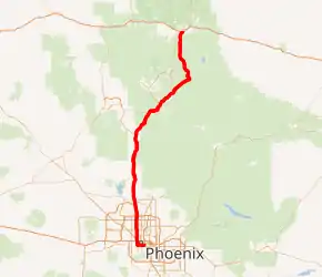
I-17 highlighted in red | ||||
| Route information | ||||
| Maintained by ADOT | ||||
| Length | 145.76 mi[1] (234.58 km) | |||
| Existed | 1957[2]–present | |||
| Major junctions | ||||
| South end | ||||
| North end | ||||
| Location | ||||
| Counties | Maricopa, Yavapai, Coconino | |||
| Highway system | ||||
| ||||
.svg.png.webp)
Since 1993, there have been plans to extend I-17 to Interstate 15 in Utah.[3]
Route description
Interstate 17 is known as the Black Canyon Freeway from the northern end of the Phoenix Metropolitan Area to a point 2.2 miles (3.5 km) south of The Stack interchange with Interstate 10 northwest of Downtown Phoenix. (It is accompanied by frontage roads for most of this portion, and they carry the Black Canyon Highway name to distinguish from the freeway status.) At the Durango Curve southwest of downtown, between the 19th Avenue and Buckeye Road interchanges, it picks up the designation Maricopa Freeway all the way to the southern terminus at the second Interstate 10 junction. It is one of the metropolitan area's primary freeways.[1][4] It has two interchanges with Interstate 10 in Phoenix.
I-17 had the unusual distinction of starting at approximately milepost 194 instead of at milepost 0. This was a holdover from Arizona's old system of marking mileposts, where a branching route would continue the milepost numbering of its original host, instead of starting over at zero. Interstate 17 inherited its milepost locations from SR 69, which the freeway replaced between Phoenix and Cordes Junction. SR 69's mileposting was such that it coincided with US 89's mileposting, which was 201.6 where the two routes intersected. When I-17 was constructed, the existing mileposting for SR 69 was retained.[1][4]
I-17 is closed to bicycles and pedestrians south of Anthem Way (exit 35) in the Anthem area, but is open to them north of this point.
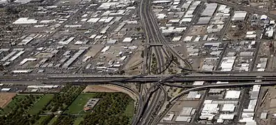 "The Stack", intersection of Interstate 10 and I-17. Looking north up I-17, downtown Phoenix.
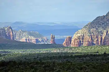 View of the Red Rocks of Sedona from I-17, just south of Munds Park
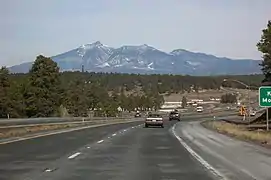 Interstate 17 near Flagstaff
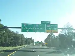 Northern terminus at I-40 in Flagstaff
History
In 1936, SR 69 was established as a state route from Phoenix north to Prescott.[5][6] The road was completed by 1940 to Prescott. In 1954, a new route north to Flagstaff was established as SR 79. By 1961, the roadway from Phoenix to Flagstaff had been established, but not to Interstate standards.[7] By 1971, I-17 had been completed from Phoenix northward to Camp Verde where a short stretch had not been completed to standards. The stretch from SR 279 north to SR 179 was also complete. The largest section yet to be completed was from SR 179 north to Flagstaff. This segment was still just a two-lane roadway, but it did have full traffic interchanges built at crossroads. The portion from I-40 south to the Flagstaff Municipal Airport had been completed by this time.[8]
In 2021, ADOT began replacing SR 69 exit numbers with I-17 exit numbers per federal requirements on the Manual on Uniform Traffic Control Devices.
Future
The existing interchange with Happy Valley Road in Phoenix was converted to a diverging diamond interchange (DDI). The project was finished in the fall of 2020.[9]
Exit list
Old exits on I-17 were numbered according to SR 69 mileposts.
| County | Location | mi[1] | km | Old exit | New exit | Destinations | Notes |
|---|---|---|---|---|---|---|---|
| Maricopa | Phoenix | 0.00 | 0.00 | — | 0A | Southern end of US 60 concurrency; southern terminus; Maricopa Freeway continues east as I-10/US 60; I-10 exit 150A | |
| 0.31 | 0.50 | 194 | 0B | Southbound exit and northbound entrance; I-10 exit 150 | |||
| 1.14 | 1.83 | 195A | 1 | 16th Street | Southbound exit and northbound entrance | ||
| 2.15 | 3.46 | 195B | 2 | 7th Street, Central Avenue | No southbound signage for Central Avenue | ||
| 3.16 | 5.09 | 196 | 3 | 7th Avenue, Central Avenue | No northbound signage for Central Avenue | ||
| 4.16 | 6.69 | 197 | 4 | 19th Avenue, Durango Street | No northbound signage for Durango Street | ||
| — | — | Planned interchange at Durango Curve | |||||
| Durango Curve; Maricopa Freeway transitions to the Black Canyon Freeway | |||||||
| 5.03 | 8.10 | 198 | 5A | Buckeye Road | Northbound exit only | ||
| 5.34 | 8.59 | 199A | 5B | Grant Street, Buckeye Road | Signed as exit 5A southbound; no northbound signage for Buckeye Road | ||
| 5.73 | 9.22 | 199B | 5B | Jefferson Street | Southbound exit only | ||
| 5.88 | 9.46 | 5C | Adams Street, Van Buren Street | Northbound exit and entrance; Van Buren Street is former I-10 Bus. | |||
| 6.49 | 10.44 | 200A | 6 | The Stack; I-10 exit 143 | |||
| 7.05 | 11.35 | 200B | 7 | McDowell Road, Van Buren Street | No northbound signage for Van Buren Street | ||
| 7.84 | 12.62 | — | — | Grand Avenue | Closed in the 1980s; former US 60/US 70/US 89/SR 93 | ||
| 8.09 | 13.02 | 201 | 8 | Northern end of US 60 concurrency; no southbound signage for Grand Avenue | |||
| 9.08 | 14.61 | 202 | 9 | Indian School Road | |||
| 10.08 | 16.22 | 203 | 10 | Camelback Road | |||
| 11.09 | 17.85 | 204 | 11 | Bethany Home Road | |||
| 12.09 | 19.46 | 205 | 12 | Glendale Avenue | |||
| 13.09 | 21.07 | 206 | 13 | Northern Parkway | |||
| 14.14 | 22.76 | 207 | 14 | Dunlap Avenue | |||
| 15.13 | 24.35 | 208 | 15 | Peoria Avenue | |||
| 16.13 | 25.96 | 209 | 16 | Cactus Road | |||
| 17.12 | 27.55 | 210 | 17 | Thunderbird Road | |||
| 18.12 | 29.16 | 211 | 18 | Greenway Road | |||
| 19.13 | 30.79 | 212 | 19 | Bell Road | |||
| 20.15 | 32.43 | 214 | 20 | Union Hills Drive, Yorkshire Drive | Signed as exits 20A (Union Hills) and 20B (Yorkshire) northbound | ||
| 21.11 | 33.97 | 214C | 21 | Loop 101 exits 23B-C; northbound entrance includes direct exit ramp onto Deer Valley Road (exit 22) | |||
| 21.66– 22.16 | 34.86– 35.66 | 215 | 22 | Rose Garden Lane, Deer Valley Road | |||
| 23.27 | 37.45 | 217 | 23 | Pinnacle Peak Road | |||
| 24.19 | 38.93 | 218 | 24 | Happy Valley Road | Diverging diamond interchange | ||
| 25.23 | 40.60 | 219 | 25 | Jomax Road | |||
| 27.25 | 43.85 | 220 | 27 | Dixileta Drive | Northbound exit and southbound entrance | ||
| 28.19 | 45.37 | 221 | 28 | Loop 303 exit 137; future clockwise terminus of Loop 303 | |||
| Northern terminus of Black Canyon Freeway | |||||||
| 29.17 | 46.94 | 222 | 29 | Dove Valley Road | |||
| 30.17 | 48.55 | 223 | 30 | Signed as exits 29A (east) and 29B (west) northbound; eastern terminus of SR 74 | |||
| Anthem | 31.70 | 51.02 | 225 | 31 | Pioneer Road | ||
| 33.21 | 53.45 | 227 | 33 | Daisy Mountain Drive | |||
| 35.24 | 56.71 | 229 | 35 | Anthem Way | |||
| New River | 38.20 | 61.48 | 232 | 38 | New River | ||
| 42.18 | 67.88 | 236 | 42 | Table Mesa Road | |||
| Maricopa–Yavapai county line | Black Canyon City | 48.29 | 77.72 | 242 | 48 | Black Canyon City, Rock Springs | Former I-17 Bus. north |
| Yavapai | 50.56 | 81.37 | 244 | 50 | Black Canyon City | Former I-17 Bus. south | |
| | 54.36 | 87.48 | 248 | 54 | Bumble Bee, Crown King | ||
| | 58.48 | 94.11 | 252 | 58 | Sunset Point Rest Area and Scenic View | Frontage roads provide all-direction access to a unified Rest Area / Scenic View off west side of freeway | |
| | 61.85 | 99.54 | 256 | 61 | Badger Springs Road | ||
| Cordes Lakes | 65.23 | 104.98 | 259 | 65 | Bloody Basin Road | ||
| 68.44 | 110.14 | 262 | 68A | Northbound exit and southbound entrance | |||
| 68.77 | 110.67 | 263 | 68B | Signed as exit 68 southbound; northbound exit signed as Arcosanti Road only | |||
| | 74.53 | 119.94 | 268 | 74 | Orme Road, Dugas Road | ||
| | 84.16 | 135.44 | 278 | 84 | Northern terminus of SR 169 | ||
| | 89.04 | 143.30 | — | — | NB Runaway Truck ramp | Northbound left exit (between mile markers 89 and 90) and southbound left entrance | |
| Camp Verde | 91.31 | 146.95 | 285 | 91 | General Crook Trail | ||
| 93.06 | 149.77 | 287 | 93 | Former SR 279 | |||
| 95.74 | 154.08 | 289 | 95 | Montezuma Castle National Monument | |||
| Lake Montezuma | 99.04 | 159.39 | 293 | 99 | Eastern terminus of CR 30 | ||
| | 102.29– 102.36 | 164.62– 164.73 | McGuireville Rest Areas | ||||
| | 104.75 | 168.58 | 298 | 104 | Southern terminus of SR 179 | ||
| | 106.12 | 170.78 | — | — | SB Runaway Truck ramp | Southbound between mile markers 106 and 107 | |
| | 112.09 | 180.39 | 306 | 112 | Stoneman Lake Road | ||
| Coconino | | 118.67 | 190.98 | — | — | SB Scenic View (and Brake Check Area) | Southbound only between mile markers 118 and 119; no services |
| | 121.37 | 195.33 | 315 | 121 | Rocky Park Road | ||
| | 123.65 | 199.00 | 317 | 123 | Fox Ranch Road | ||
| | 126.29 | 203.24 | 320 | 126 | Schnebly Hill Road | ||
| Munds Park | 128.51 | 206.82 | 322 | 128 | Munds Park | ||
| 129.04 | 207.67 | Christensen Rest Areas; closed | |||||
| | 132.01 | 212.45 | 326 | 132 | Willard Springs Road | ||
| | 134.55 | 216.54 | 328 | 134 | Newman Park Road | ||
| | 136.90 | 220.32 | 331 | 136 | Kelly Canyon Road | ||
| Kachina Village | 139.65 | 224.74 | 333 | 139 | Kachina Boulevard, Mountainaire Road | ||
| Flagstaff | 143.17 | 230.41 | 337 | 143 | Southern end of SR 89A concurrency | ||
| 145.55 | 234.24 | 339 | 145 | Lake Mary Road – Mormon Lake | Northbound exit only | ||
| 145.76 | 234.58 | 340 | 146 | Northern end of SR 89A concurrency; signed as exits 146A (east) and 146B (west); I-40 exit 195; freeway continues as SR 89A north | |||
| 146.21 | 235.30 | 341 | 147 | McConnell Drive – Northern Arizona University | Northbound exit and southbound entrance; not officially part of I-17; ADOT signed as exit 147; SR 89A mile marker 401 | ||
1.000 mi = 1.609 km; 1.000 km = 0.621 mi
| |||||||
Former business route
Black canyon city
| |
|---|---|
| Location | Black Canyon City |
| Length | 3.0 mi (4.8 km) |
State Business Route 17 (also known as SR 17 Bus.) was a former 3.0-mile (4.8 km) business loop of Interstate 17 that served the west side of Black Canyon City, Arizona. I-17 Business followed Old Black Canyon Highway (formerly SR 69 before I-17 replaced most of the route between Phoenix and Cordes Junction) from exit 242 south of town at a diamond interchange to another diamond interchange at exit 244 north of town. The business route was subsequently transferred from state to local maintenance and because of ADOT's policy of not signing business loops on non-state maintained roadways, the route was decommissioned in 2011.[10]
Major intersections
The entire route was in Yavapai County.
| Location | mi | km | Destinations | Notes | |
|---|---|---|---|---|---|
| | 0.000 | 0.000 | Southern terminus; I-17 exit 242 | ||
| Black Canyon City | 3.000 | 4.828 | Northern terminus; I-17 exit 244 | ||
| 1.000 mi = 1.609 km; 1.000 km = 0.621 mi | |||||
References
- Roadway Inventory Management Section, Multimodal Planning Division (December 31, 2013). "2013 State Highway System Log" (PDF). Arizona Department of Transportation. Retrieved May 23, 2020.
- https://www.azcentral.com/story/news/local/phoenix-contributor/2017/02/21/which-freeway-came-first-valley/97871258/
- "Arizona officials seek extension of I-17 into Utah". Associated Press. Deseret News. January 2, 1993. Retrieved January 27, 2021.
- Google (February 15, 2008). "Overview map of I-17" (Map). Google Maps. Google. Retrieved February 15, 2008.
- Arizona and New Mexico Road Map (Map). Rand McNally. 1938. Retrieved November 27, 2011.
- Arizona Department of Transportation. "ADOT Right-of-Way Resolution 1936-P-624". Retrieved April 22, 2008.
- State Highway Department Road Map of Arizona (Map). Rand McNally. 1961. Retrieved November 27, 2011.
- State Highway Department Road Map of Arizona (Map). Arizona State Highway Department. 1971. Retrieved November 27, 2011.
- "Happy Valley Road". www.azdot.gov. Retrieved August 26, 2019.
- "Interstate Business Route 17". interstate-guide.com. Retrieved November 6, 2020.
External links
| Wikimedia Commons has media related to Interstate 17. |
| Signed | |
|---|---|
| Unsigned | |
| Lists | |
| Other | |
Major Interstates highlighted | |
