Arkansas Highway 185
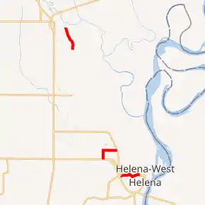
Arkansas Highway 185 (AR 185, Ark. 185, and Hwy. 185) is the designation for a state highway in the U.S. state of Arkansas. The route is split into three sections, which are all located in eastern Arkansas. The first section begins at AR 242 and ends at US Highway 49 Business (US 49B) in Helena-West Helena. The second section begins at US 49 near Wycamp, or just west of Helena-West Helena, and ends at AR 242 just north of Helena-West Helena. The third section begins at County Road 215 (CR 215) in Lee County and ends at AR 44 near Marianna.[2][3]
| ||||
|---|---|---|---|---|

| ||||
| Route information | ||||
| Maintained by ArDOT | ||||
| Section 1 | ||||
| Length | 2.27 mi[1] (3.65 km) | |||
| South end | ||||
| North end | ||||
| Section 2 | ||||
| Length | 2.56 mi[1] (4.12 km) | |||
| South end | ||||
| North end | ||||
| Section 3 | ||||
| Length | 2.67 mi[1] (4.30 km) | |||
| South end | County Road 215, Lee County | |||
| North end | ||||
| Highway system | ||||
| ||||
Route description
Helena-West Helena route
The southern terminus for AR 185 is at AR 242 in West Helena, just east of US 49. The route heads almost directly east for about 2.3 miles (3.7 km), directly traveling through Crowley's Ridge before reaching its northern terminus at US 49B in Helena. The route itself does not intersect any other signed highways.[4]
Airport Road
The southern terminus for AR 185 is at US 49 in Wycamp, or just west of West Helena. The route heads north for about one mile (1.6 km), before reaching an intersection near Thompson-Robbins Airport. The route heads almost directly east for about 1.5 miles (2.4 km) until it reaches its northern terminus at AR 242 just north of Helena-West Helena.[5]
Lee County route
The southern terminus for AR 185 in Lee County is at CR 215 in the St. Francis National Forest. The route heads almost directly north for about 2.7 miles (4.3 km) before reaching its northern terminus at AR 44 just east of Marianna. The route is very rural and does not intersect any other highways or communities.[6]
Major intersections
| County | Location | mi | km | Destinations | Notes | ||
|---|---|---|---|---|---|---|---|
| Phillips | Helena-West Helena | 0.00 | 0.00 | Southern terminus | |||
| 2.28 | 3.67 | Northern terminus | |||||
| Gap in route | |||||||
| Phillips | Wycamp | 0.00 | 0.00 | Southern terminus | |||
| | 1.01 | 1.63 | |||||
| | 2.55 | 4.10 | Northern terminus | ||||
| Gap in route | |||||||
| Lee | | 0.00 | 0.00 | Southern terminus | |||
| Marianna | 2.55 | 4.10 | Northern terminus | ||||
| 1.000 mi = 1.609 km; 1.000 km = 0.621 mi | |||||||
References
- Planning and Research Division (March 28, 2012). "Arkansas Road Log Database". Little Rock: Arkansas State Highway and Transportation Department. Archived from the original (MBD) on June 23, 2011. Retrieved April 13, 2012.
- Planning and Research Division (n.d.). General Highway Map: Phillips County (PDF) (Map). 1:62,500. Little Rock: Arkansas State Highway and Transportation Department.
- Planning and Research Division (n.d.). General Highway Map: Lee County (PDF) (Map). 1:62,500. Little Rock: Arkansas State Highway and Transportation Department.
- Google (February 8, 2021). "Overview: AR 185 (Helena-W. Helena)" (Map). Google Maps. Google. Retrieved February 8, 2021.
- Google (February 8, 2021). "Overview: AR 185 (Wycamp-Airport Road)" (Map). Google Maps. Google. Retrieved February 8, 2021.
- Google (February 8, 2021). "Overview: AR 185 (Lee County)" (Map). Google Maps. Google. Retrieved February 8, 2021.
External links
 Media related to Arkansas Highway 185 at Wikimedia Commons
