Arkansas Highway 76
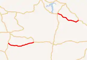
Arkansas Highway 76 (AR 76, Ark. 76 and Hwy. 76) is the designation for a state Highway in the U.S. state of Arkansas. AR 76 is located in southwest Arkansas, and is split into two sections. The first section begins at U.S. Route 371 (US 371), and ends at US 278. The second section begins at AR 57 and AR 387 south of Chidester, and ends at AR 24 near Bragg City, or about 6.5 miles (10.5 km) northwest of Camden. Both sections are very rural.[1][2]
| ||||
|---|---|---|---|---|
| ||||
| Route information | ||||
| Maintained by ArDOT | ||||
| Section 1 | ||||
| Length | 7.2 mi (11.6 km) | |||
| West end | ||||
| East end | ||||
| Section 2 | ||||
| Length | 6.6 mi (10.6 km) | |||
| West end | ||||
| East end | ||||
| Location | ||||
| Counties | Nevada, Ouachita | |||
| Highway system | ||||
| ||||

Route description
Section 1
The western terminus for AR 76 is at US 371 just south of Rosston. From there, the route heads east towards US 278 where its eastern terminus is located. The entire route is about 7.2 miles (11.6 km) long and does not intersect any communities or other highways.[3]
Section 2
The western terminus for AR 76 is at AR 57 and AR 387 just south of Chidester, or just west of White Oak Lake State Park. From there, the route heads east towards AR 24, intersecting Poison Springs Battleground State Park along the way. Highway 76's eastern terminus is at AR 24, just southeast of Bragg City or just northwest of Camden. The entire route is about 6.6 miles (10.6 km) long and does not intersect any other communities or highways.[4]
Major intersections
| County | Location | mi | km | Destinations | Notes | ||
|---|---|---|---|---|---|---|---|
| Nevada | | 0.0 | 0.0 | Western terminus | |||
| | 7.2 | 11.6 | Eastern terminus | ||||
| Gap in route | |||||||
| Ouachita | Chidester | 0.0 | 0.0 | Western terminus; AR 387 southern terminus | |||
| Bragg City | 6.6 | 10.6 | Eastern terminus | ||||
| 1.000 mi = 1.609 km; 1.000 km = 0.621 mi | |||||||
References
- Ouachita County (PDF) (Map). Arkansas Department of Transportation. Retrieved December 19, 2020.
- Nevada County (PDF) (Map). Arkansas Department of Transportation. Retrieved December 19, 2020.
- Google. "AR-76 to AR-76" (Map). Google Maps. Google.
- Google. "109-101 State Hwy 76 to 828-864 AR-57" (Map). Google Maps. Google.