Armori
Armori is a town and municipal council in the Gadchiroli district in the Indian state of Maharashtra.[2] It is connected with the National Highway NH-353C.
Armori | |
|---|---|
Town | |
 Main road in Armori | |
 Armori Location in Maharashtra, India  Armori Armori (India)  Armori Armori (Asia) | |
| Coordinates: 20.46°N 79.98°E | |
| Country | |
| State | Maharashtra |
| District | Gadchiroli |
| Government | |
| • Type | Municipal Council |
| • Body | Armori Municipal Council (AMC) |
| Elevation | 199 m (653 ft) |
| Population (2011) | |
| • Total | 19,000 |
| Language | |
| • Official | Marathi[1] |
| Time zone | UTC+5:30 (IST) |
| PIN | 441208 |
| Telephone code | 07137 |
It is located on the left of the Wainganga River, a tributary of the Pranahita River which meets the Godavari River.
Geography
Armori is located at 20.46°N 79.98°E.[3] It has an average elevation of 199 metres (676 feet).
It is part of Desaiganj subdivision of Gadchiroli district along with the tehsils Desaiganj, Kurkheda and Korchi.
Transport
Road
Armori is well connected to major industrial and commercial places by road. It is about 120 km from the city of Nagpur and about 36 km from district headquarters, Gadchiroli. The Maharashtra State Road Transport Corporation (MSRTC) runs buses connecting Gadchiroli to Nagpur via Armori, Brahmpuri, Nagbhid, Umrer with a frequency of about 45 min.
Rail
Nearest railway station is Wadsa (Desaiganj) which is 18 km from Armori town. The other nearby railway stations are Brahmpuri (21 km), Nagpur (120 km). Railway ministry proposed new rail line from Wadsa (Desaiganj) to Gadchiroli via Armori. The project has begun and projected to finish till 2022.
Air
Nearest airport is Dr. Babasaheb Ambedkar International Airport, Nagpur which is about 130 km from the town of Armori.
See also
References
- "52nd REPORT OF THE COMMISSIONER FOR LINGUISTIC MINORITIES IN INDIA" (PDF). nclm.nic.in. Ministry of Minority Affairs. Archived from the original (PDF) on 25 May 2017. Retrieved 6 July 2019.
- "Armori Town Council of Gadchiroli District 2018-2019 | District Gadchiroli, Government of Maharashtra | India". Gadchiroli District. Retrieved 23 January 2021.
- Falling Rain Genomics, Inc - Chamorshi
Gadchiroli district topics | ||
|---|---|---|
| History | 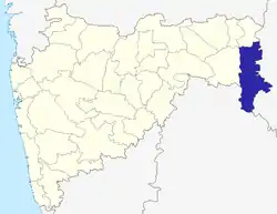 | |
| Geography | ||
| Cities and towns | ||
| Transport | ||
| Culture | ||
| Lok Sabha constituencies | ||
| Vidhan Sabha constituencies | ||
