Gadchiroli district
Gadchiroli district is an administrative district in Maharashtra, India. The city of Gadchiroli is the administrative headquarters of the district.
Gadchiroli district | |
|---|---|
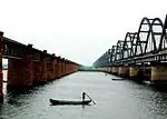
 Kathani river in Gadchiroli | |
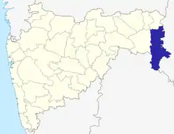 Location of Gadchiroli district in Maharashtra | |
| Coordinates (Gadchiroli): 20°11′10″N 80°00′19″E | |
| Country | India |
| State | Maharashtra |
| Administrative division | Nagpur Division |
| Headquarters | Gadchiroli |
| Tehsils | |
| Government | |
| • District Collector | Deepak Singla, IAS |
| • Lok Sabha constituencies | 1. Gadchiroli-Chimur (shared with Chandrapur district)[1] |
| Area | |
| • Total | 14,412 km2 (5,565 sq mi) |
| Population (2011) | |
| • Total | 1,072,942 |
| • Density | 74/km2 (190/sq mi) |
| • Urban | 6.93% |
| Demographics | |
| • Literacy | 60.1% |
| • Sex ratio | 976 |
| Major highways | NH 63, NH 353C, NH 353D, NH 542 & NH 930 |
| Average annual precipitation | 1704 mm |
| Website | Official website |
Extent and history
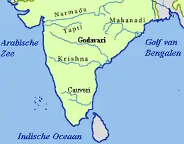
Maharashtra tapers in the east, where this district forms the south-east corner such that Gondia district forms the north-east corner to its north; others neighbouring comprise Chandrapur district to the west, Chhattisgarh state to the east, and Telangana state to the south and southwest.
It was created on 26 August 1982 by the separation of Gadchiroli and Sironcha taluks from Chandrapur district.
Strategic planning
The district is currently a part of the Red Corridor.[2]
Divisions
The district is divided into three sub-divisions: Gadchiroli, Aheri and Desaiganj. These are each further divided into four talukas: Gadchiroli sub-division consists of Gadchiroli, Dhanora, Chamorshi and Mulchera talukas; Aheri sub-division consists of Aheri, Sironcha, Etapalli and Bhamragad talukas; and Desaiganj (Wadsa) sub-division consists of Wadsa, Armori, Kurkheda and Korchi talukas. There are 557 gram panchayats (village councils) and 1,688 Revenue Villages. The district has 12 panchayat samitis (local development-block governments). Only three municipalities, Gadchiroli, Wadsa (Desaiganj), and Armori exist in the district.
Following the delimitation of the constituencies in 2008, the district had three Vidhan Sabha (legislative assembly) constituencies: Gadchiroli, Armori and Aheri. All of these are part of the newly carved Gadchiroli-Chimur Lok Sabha constituency.[3]
Natural geography
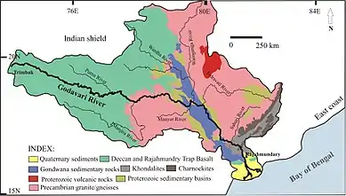
Established on 26 August 1982 The main river basin of the district is the Godavari, which flows west-to-east and forms the southern boundary of the district. The major tributaries of the Godavari are the Indravati and the Pranhita, the latter of which is formed by the confluence of the Wainganga and the Wardha near Chaprala village of Chamorshi taluka.
Dhanora, Etapalli, Aheri and Sironcha talukas in the eastern part of the district are covered by forest. Hills are found in Bhamragad, Tipagad, Palasgad and Surjagad area. The eastern part of Gadchiroli, bordering Chhattisgarh state, is mainly hilly.
Demography
| Year | Pop. | ±% p.a. |
|---|---|---|
| 1901 | 177,244 | — |
| 1911 | 225,086 | +2.42% |
| 1921 | 220,771 | −0.19% |
| 1931 | 254,088 | +1.42% |
| 1941 | 290,730 | +1.36% |
| 1951 | 324,962 | +1.12% |
| 1961 | 386,392 | +1.75% |
| 1971 | 522,229 | +3.06% |
| 1981 | 637,336 | +2.01% |
| 1991 | 787,010 | +2.13% |
| 2001 | 970,294 | +2.12% |
| 2011 | 1,072,942 | +1.01% |
| source:[4] | ||
According to the 2011 census Gadchiroli district has a population of 1,072,942,[5] roughly equal to the nation of Cyprus[6] or the US state of Rhode Island.[7] This gives it a ranking of 424th in India (out of a total of 640).[5] The district has a population density of 74 inhabitants per square kilometre (190/sq mi).[5] Its population growth rate during 2001–2011 was 10.46%.[5] Gadchiroli has a sex ratio of 975 females for every 1000 males,[5] and a literacy rate of 70.55%.[5]
Scheduled caste and scheduled tribe population in the district is 108,824 and 371,696. The tribal community population that resides in the district is 38.3%.[8]
At the time of the 2011 Census of India, 56.38% of the population in the district spoke Marathi, 14.21% Gondi, 9.47% Santali, 8.87% Telugu, 5.12% Bengali, 2.15% Hindi and 1.69 Chhattisgarhi as their first language.[9]
Relatively low population and green environment
As of 2011 it is the second-least-populous district of Maharashtra (out of 39), after Sindhudurg.[5]
Economy
The district is categorised as tribal and undeveloped, with farming as the main occupation. Forests cover more than 79.36% of the hilly geographical of the district. The district produces bamboo and Tendu leaves, and paddy is the main agricultural product. Other agriculture includes sorghum, linseed, pigeonpea (tur), and wheat.
The only large-scale industry in the district is a paper mill at Ashti in Chamorshi taluka and the paper pulp factory at Desaiganj. There are many rice mills in the district. The Tussar silk worm centre is in Armori taluka. 18.5 kilometres (11.5 mi) of railway lines pass through the district.
The district is known for activity of Naxalites – the People's Liberation Guerrilla Army – who have taken shelter in the dense forests and hills.
In 2006 the Ministry of Panchayati Raj named Gadchiroli among the country's 250 most-backward districts (out of a total of 640).[10] It is one of the twelve districts in Maharashtra currently receiving funds from the Backward Regions Grant Fund Programme (BRGF).[10]
Health
The Lok Biradari Prakalpa (LBP) situated at Hemalkasa in the Bhamragad taluka is one of the major institutions offering healthcare and education services to the local Madia-Gond tribals. LBP was envisioned by the late Gandhian, Dr. Murlidhar Devidas Amte, fondly called Baba Amte. His family consisting of Dr. Prakash Amte, Dr. Mandakini Amte and their children currently work at the LBP.[11]
Education
The government recently established Gondwana University on dated 27 September 2011 in Gadhchiroli district.[12]
High schools
- Gondwana Sainiki Vidyalaya, Gadchiroli
- Platinum Jubilee School and Junior College (Science), Gadchiroli
- Shriniwas High School Ankisa
- Dharmarao High School Sironcha
- Republic English Medium School, Aheri
- School Of Scholars, Gadchiroli
- Rampuri Primary School
- Shri. Shivaji High School, Gadchiroli
- Z.P. High School, Gadchiroli
- Carmel High School, Gadchiroli
- Vasant Vidyalaya High School
- Rani Durgavati High School & Junior College Allapalli
- Netaji Subhash Chandra Jr. College, Sundernagar
- Indira Gandhi Memoriyal High School & Junior College, Subhashgram
- Mahatma Gandhi vidyalaya, Armori
- Dr. Ambedkar vidyalaya, Armori
- Hitakarani high school, Armori
- Swami Vivekanda Vidyalaya, Armori
- Adarsh English High school, Desaiganj (wadsa)
- Mahatma Gandhi Vidyalaya, Desaiganj (Wadsa)
- Dr. Babasaheb Ambedkar Vidyalaya, Desaiganj (Wadsa)
- Pushpa Priya Devi High School & Junior science College Jimalgatta
Model school Aheri
- Platinum Jubilee School & Jr. College (science)
- Shriniwas Junior College, Ankisa
- Z. P. Junior College of Science Sironcha
- Shivaji Junior Science College
- Govt ITI Complex, Gadchiroli
- Mahatma Gandhi junior college, Armori
- N.S.C Jr. College Sundarnagar
- Adarsh English High School & Junior College, Desaiganj (Wadsa)
- Mahatma Gandhi Vidyalaya & Junior College, Desaiganj (Wadsa)
Senior (degree) colleges
- Bhagvantrao Arts College Sironcha
- Shivaji Science College Gadchiroli
- Mahila Mahavidyalaya, Gadchiroli
- Government Science College, Gadchiroli
- Government Polytechnic, Gadchiroli
- College of Agriculture, Sonapur complex Gadchiroli
- Model College Gadchiroli
- Namdeorao Poreddiwar College of Engineering and Technology[13]
- Fule-Ambedkar College of Social Work, Gadchiroli
- Mahatma Gandhi college, Armori
- Chanakya Academy, Aheri (Competitive Exam Coaching Classes Center)
- Adarsh Mahavidyalaya Art & Com. Desaiganj (Wadsa)
Sainath Adhayapak vidyalaya, Murkhala Prof.Jogendra kawade college Vairagad Shri govindrao Munghate Art and Science college kurkheda
Important places
- Wadadham Fossil Park, tah, Sironcha
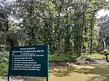
- Chaprala Wildlife Sanctuary
- Bhamragarh Wildlife Sanctuary
- Lok Biradari Prakalp, Hemalkasa
- Binagunda waterfall, Bhamragad
- Tipagad, tah. Korchi
- Khobramendha, tag dhanora
- Bhandareshwar temple, tag Armori
- Search hospital, Chatgaon
- Desaiganj Wadsa, market place
- Markanda dev, Tah Chamorshi
- Somnur sangam tah, Sironcha
- Pranhita Sangam tah, Sironcha
- Triveni sangam bhamragad
See also
References
- Election Commission website
- "83 districts under the Security Related Expenditure Scheme". IntelliBriefs. 11 April 2019. Retrieved 17 April 2019.
- "District wise List of Assembly and Parliamentary Constituencies". Chief Electoral Officer, Maharashtra website. Archived from the original on 18 March 2010.
- Decadal Variation In Population Since 1901
- "District Census 2011". Census2011.co.in. 2019. Retrieved 19 April 2019.
- US Directorate of Intelligence. "Country Comparison:Population". Retrieved 1 October 2011.
Cyprus 1,120,489 July 2011 est.
- "2010 Resident Population Data". U. S. Census Bureau. Archived from the original on 1 January 2011. Retrieved 30 September 2011.
Rhode Island 1,052,567
- "Archived copy". Archived from the original on 3 July 2007. Retrieved 27 August 2009.CS1 maint: archived copy as title (link)
- 2011 Census of India, Population By Mother Tongue
- Ministry of Panchayati Raj (8 September 2009). "A Note on the Backward Regions Grant Fund Programme" (PDF). National Institute of Rural Development. Archived from the original (PDF) on 5 April 2012. Retrieved 27 September 2011.
- People's Brotherhood Project. Lok Biradari Prakalp. Retrieved on 2016-07-31.
- "404". gondwanauniversity.org. Retrieved 10 April 2017.
- "NAMDEORAO POREDDIWAR COLLEGE OF ENGINEERING AND TECHNOLOGY GADCHIROLI". ncet.org.in. Archived from the original on 31 March 2012. Retrieved 10 April 2017.
External links
| Wikimedia Commons has media related to Gadchiroli district. |
Places adjacent to Gadchiroli district | |
|---|---|
| Districts of Vidarbha | |
|---|---|
| Cities with municipal corporations | |
Portal:India | |
| Topics | |||||||||||||
|---|---|---|---|---|---|---|---|---|---|---|---|---|---|
| Regions | |||||||||||||
| Divisions and Districts |
| ||||||||||||
| Million-plus cities in Maharashtra | |||||||||||||
| Other cities with municipal corporations | |||||||||||||
Portal:India | |||||||||||||