Arrondissement of Alès
The arrondissement of Alès is an arrondissement of France in the Gard department in the Occitanie region. It has 97 communes.[1] Its population is 148,139 (2016), and its area is 1,304.2 km2 (503.6 sq mi).[2]
Alès | |
|---|---|
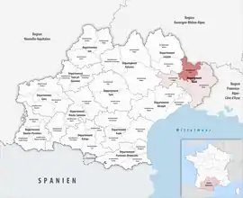 Location within the region Occitanie | |
| Country | France |
| Region | Occitanie |
| Department | Gard |
| No. of communes | 97 |
| Subprefecture | Alès |
| Area | |
| • Total | 1,304.2 km2 (503.6 sq mi) |
| Population (2016) | |
| • Total | 148,139 |
| • Density | 114/km2 (300/sq mi) |
| INSEE code | 301 |
Composition
The communes of the arrondissement of Alès, and their INSEE codes, are:[1]
- Alès (30007)
- Allègre-les-Fumades (30008)
- Anduze (30010)
- Aujac (30022)
- Bagard (30027)
- Barjac (30029)
- Bessèges (30037)
- Boisset-et-Gaujac (30042)
- Bonnevaux (30044)
- Bordezac (30045)
- Boucoiran-et-Nozières (30046)
- Bouquet (30048)
- Branoux-les-Taillades (30051)
- Brignon (30053)
- Brouzet-lès-Alès (30055)
- Castelnau-Valence (30072)
- Cendras (30077)
- Chambon (30079)
- Chamborigaud (30080)
- Concoules (30090)
- Corbès (30094)
- Courry (30097)
- Cruviers-Lascours (30100)
- Deaux (30101)
- Euzet (30109)
- Gagnières (30120)
- Générargues (30129)
- Génolhac (30130)
- La Grand-Combe (30132)
- Lamelouze (30137)
- Laval-Pradel (30142)
- Lézan (30147)
- Les Mages (30152)
- Malons-et-Elze (30153)
- Martignargues (30158)
- Le Martinet (30159)
- Massanes (30161)
- Massillargues-Attuech (30162)
- Méjannes-le-Clap (30164)
- Méjannes-lès-Alès (30165)
- Meyrannes (30167)
- Mialet (30168)
- Molières-sur-Cèze (30171)
- Mons (30173)
- Monteils (30177)
- Navacelles (30187)
- Ners (30188)
- Peyremale (30194)
- Les Plans (30197)
- Ponteils-et-Brésis (30201)
- Portes (30203)
- Potelières (30204)
- Ribaute-les-Tavernes (30214)
- Rivières (30215)
- Robiac-Rochessadoule (30216)
- Rochegude (30218)
- Rousson (30223)
- Saint-Ambroix (30227)
- Saint-Bonnet-de-Salendrinque (30236)
- Saint-Brès (30237)
- Saint-Césaire-de-Gauzignan (30240)
- Saint-Christol-lès-Alès (30243)
- Saint-Denis (30247)
- Sainte-Cécile-d'Andorge (30239)
- Sainte-Croix-de-Caderle (30246)
- Saint-Étienne-de-l'Olm (30250)
- Saint-Florent-sur-Auzonnet (30253)
- Saint-Hilaire-de-Brethmas (30259)
- Saint-Hippolyte-de-Caton (30261)
- Saint-Jean-de-Ceyrargues (30264)
- Saint-Jean-de-Maruéjols-et-Avéjan (30266)
- Saint-Jean-de-Serres (30267)
- Saint-Jean-de-Valériscle (30268)
- Saint-Jean-du-Gard (30269)
- Saint-Jean-du-Pin (30270)
- Saint-Julien-de-Cassagnas (30271)
- Saint-Julien-les-Rosiers (30274)
- Saint-Just-et-Vacquières (30275)
- Saint-Martin-de-Valgalgues (30284)
- Saint-Maurice-de-Cazevieille (30285)
- Saint-Paul-la-Coste (30291)
- Saint-Privat-de-Champclos (30293)
- Saint-Privat-des-Vieux (30294)
- Saint-Sébastien-d'Aigrefeuille (30298)
- Saint-Victor-de-Malcap (30303)
- Salindres (30305)
- Les Salles-du-Gardon (30307)
- Sénéchas (30316)
- Servas (30318)
- Seynes (30320)
- Soustelle (30323)
- Tharaux (30327)
- Thoiras (30329)
- Tornac (30330)
- Vabres (30335)
- La Vernarède (30345)
- Vézénobres (30348)
History
The arrondissement of Alès was created in 1800.[3] At the January 2017 reorganisation of the arrondissements of Gard, it gained four communes from the arrondissement of Le Vigan, and it lost two communes to the arrondissement of Nîmes and six communes to the arrondissement of Le Vigan.[4]
As a result of the reorganisation of the cantons of France which came into effect in 2015, the borders of the cantons are no longer related to the borders of the arrondissements. The cantons of the arrondissement of Alès were, as of January 2015:[5]
- Alès-Nord-Est
- Alès-Ouest
- Alès-Sud-Est
- Anduze
- Barjac
- Bessèges
- Génolhac
- La Grand-Combe
- Lédignan
- Saint-Ambroix
- Saint-Jean-du-Gard
- Vézénobres
References
- "Arrondissement d'Alès (301)". INSEE. Retrieved 2019-09-30.
- "Comparateur de territoire, géographie au 01/01/2019". INSEE. Retrieved 2019-09-30.
- Historique du Gard
- "Arrêté préfectoral, 29 December 2016" (PDF). pp. 36–40. Retrieved 2019-10-10.
- "Populations légales 2012" (PDF). INSEE. December 2014. Retrieved 2019-10-10.
| Authority control |
|
|---|