Saint-Jean-de-Valériscle
Saint-Jean-de-Valériscle is a commune in the Gard department in southern France.
Saint-Jean-de-Valériscle | |
|---|---|
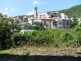 A general view of Saint-Jean-de-Valériscle | |
.svg.png.webp) Coat of arms | |
Location of Saint-Jean-de-Valériscle 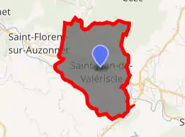
| |
 Saint-Jean-de-Valériscle  Saint-Jean-de-Valériscle | |
| Coordinates: 44°14′02″N 4°08′35″E | |
| Country | France |
| Region | Occitanie |
| Department | Gard |
| Arrondissement | Alès |
| Canton | Rousson |
| Intercommunality | Alès Agglomération |
| Government | |
| • Mayor (2008–2014) | Bernard Hilaire |
| Area 1 | 8.15 km2 (3.15 sq mi) |
| Population (2017-01-01)[1] | 669 |
| • Density | 82/km2 (210/sq mi) |
| Time zone | UTC+01:00 (CET) |
| • Summer (DST) | UTC+02:00 (CEST) |
| INSEE/Postal code | 30268 /30960 |
| Elevation | 184–529 m (604–1,736 ft) (avg. 210 m or 690 ft) |
| 1 French Land Register data, which excludes lakes, ponds, glaciers > 1 km2 (0.386 sq mi or 247 acres) and river estuaries. | |
Population
|
|
See also
References
- "Populations légales 2017". INSEE. Retrieved 6 January 2020.
| Wikimedia Commons has media related to Saint-Jean-de-Valériscle. |
| Authority control |
|---|
This article is issued from Wikipedia. The text is licensed under Creative Commons - Attribution - Sharealike. Additional terms may apply for the media files.