Saint-Christol-lès-Alès
Saint-Christol-lès-Alès is a commune in the Gard department in southern France.
Saint-Christol-lès-Alès | |
|---|---|
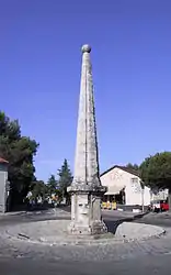 The Pyramid, erected in 1777 | |
.svg.png.webp) Coat of arms | |
Location of Saint-Christol-lès-Alès 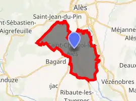
| |
 Saint-Christol-lès-Alès  Saint-Christol-lès-Alès | |
| Coordinates: 44°05′07″N 4°04′39″E | |
| Country | France |
| Region | Occitanie |
| Department | Gard |
| Arrondissement | Alès |
| Canton | Alès-1 |
| Intercommunality | Alès Agglomération |
| Government | |
| • Mayor (2014–2020) | Jean-Charles Benezet |
| Area 1 | 20.25 km2 (7.82 sq mi) |
| Population (2017-01-01)[1] | 7,030 |
| • Density | 350/km2 (900/sq mi) |
| Time zone | UTC+01:00 (CET) |
| • Summer (DST) | UTC+02:00 (CEST) |
| INSEE/Postal code | 30243 /30380 |
| Elevation | 103–391 m (338–1,283 ft) (avg. 134 m or 440 ft) |
| 1 French Land Register data, which excludes lakes, ponds, glaciers > 1 km2 (0.386 sq mi or 247 acres) and river estuaries. | |
Climate
Temperatures reached 44.1 °C (111.4 °F) in Saint-Christol-lès-Alès and Conqueyrac on 12 August 2003 during the 2003 European heat wave.[2] They were France's highest temperatures ever recorded until 28 June 2019, when temperatures reached as high as 45.9 °C (114.6 °F) in southern France.[3]
Population
| Year | Pop. | ±% |
|---|---|---|
| 1793 | 726 | — |
| 1846 | 1,260 | +73.6% |
| 1901 | 1,397 | +10.9% |
| 1926 | 1,433 | +2.6% |
| 1946 | 1,580 | +10.3% |
| 1962 | 2,025 | +28.2% |
| 1968 | 2,595 | +28.1% |
| 1975 | 3,304 | +27.3% |
| 1982 | 3,970 | +20.2% |
| 1990 | 4,973 | +25.3% |
| 1999 | 5,492 | +10.4% |
| 2008 | 6,544 | +19.2% |
| 2012 | 6,776 | +3.5% |
See also
References
- "Populations légales 2017". INSEE. Retrieved 6 January 2020.
- Météo France
- "Temperature in France breaks record as European heat wave continues". BNO News. June 28, 2019.
External links
| Wikimedia Commons has media related to Saint-Christol-lez-Alès. |
| Authority control |
|
|---|
This article is issued from Wikipedia. The text is licensed under Creative Commons - Attribution - Sharealike. Additional terms may apply for the media files.