Saint-Ambroix, Gard
Saint-Ambroix (Occitan: Sant Ambruèis) is a commune in the Gard department in southern France.
Saint-Ambroix | |
|---|---|
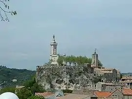 Dugas Rock | |
.svg.png.webp) Coat of arms | |
Location of Saint-Ambroix 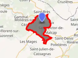
| |
 Saint-Ambroix  Saint-Ambroix | |
| Coordinates: 44°15′41″N 4°11′55″E | |
| Country | France |
| Region | Occitanie |
| Department | Gard |
| Arrondissement | Alès |
| Canton | Rousson |
| Government | |
| • Mayor (2008–2014) | Daniel Pialet |
| Area 1 | 11.74 km2 (4.53 sq mi) |
| Population (2017-01-01)[1] | 3,162 |
| • Density | 270/km2 (700/sq mi) |
| Time zone | UTC+01:00 (CET) |
| • Summer (DST) | UTC+02:00 (CEST) |
| INSEE/Postal code | 30227 /30500 |
| Elevation | 118–485 m (387–1,591 ft) (avg. 151 m or 495 ft) |
| 1 French Land Register data, which excludes lakes, ponds, glaciers > 1 km2 (0.386 sq mi or 247 acres) and river estuaries. | |
Population
|
|
See also
References
- "Populations légales 2017". INSEE. Retrieved 6 January 2020.
| Wikimedia Commons has media related to Saint-Ambroix (Gard). |
| Authority control |
|---|
This article is issued from Wikipedia. The text is licensed under Creative Commons - Attribution - Sharealike. Additional terms may apply for the media files.