Arrondissement of Montpellier
The arrondissement of Montpellier is an arrondissement of France. It is part of the Hérault département. Its INSEE code is 343 and its capital city, and prefecture of the department, is Montpellier. It has 67 communes.[1] Its population is 683,935 (2016), and its area is 1,004.8 km2 (388.0 sq mi).[2]
Montpellier | |
|---|---|
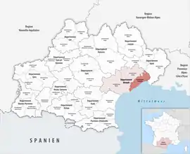 Location within the region Occitanie | |
| Country | France |
| Region | Occitanie |
| Department | Hérault |
| No. of communes | 67 |
| Prefecture | Montpellier |
| Area | |
| • Total | 1,004.8 km2 (388.0 sq mi) |
| Population (2016) | |
| • Total | 683,935 |
| • Density | 681/km2 (1,760/sq mi) |
| INSEE code | 343 |
The main cities in the arrondissement are Montpellier (268,456 inhabitants), Sète (44,558 inhabitants), Lunel (25,405 inhabitants), Frontignan (22,728 inhabitants), Mauguio (16,7865 inhabitants), Castelnau-le-Lez (16,664 inhabitants), Lattes (15,719 inhabitants) and Mèze (10,917 inhabitants).[3]
Geography
The arrondissement covers the northeastern part of the department and is bordered to the north and northeast by the Gard department, to the east and south by the Gulf of Lion (Mediterranean Sea), to the southwest by the arrondissement of Béziers and to the west by the arrondissement of Lodève.
Composition
The communes of the arrondissement of Montpellier are (with their INSEE codes):[1]
- Baillargues (34022)
- Balaruc-le-Vieux (34024)
- Balaruc-les-Bains (34023)
- Beaulieu (34027)
- Boisseron (34033)
- Bouzigues (34039)
- Campagne (34048)
- Candillargues (34050)
- Castelnau-le-Lez (34057)
- Castries (34058)
- Clapiers (34077)
- Cournonsec (34087)
- Cournonterral (34088)
- Le Crès (34090)
- Entre-Vignes (34246)
- Fabrègues (34095)
- Frontignan (34108)
- Galargues (34110)
- Garrigues (34112)
- Gigean (34113)
- Grabels (34116)
- La Grande-Motte (34344)
- Jacou (34120)
- Juvignac (34123)
- Lansargues (34127)
- Lattes (34129)
- Lavérune (34134)
- Loupian (34143)
- Lunel (34145)
- Lunel-Viel (34146)
- Marseillan (34150)
- Marsillargues (34151)
- Mauguio (34154)
- Mireval (34159)
- Montaud (34164)
- Montbazin (34165)
- Montferrier-sur-Lez (34169)
- Montpellier (34172)
- Mudaison (34176)
- Murviel-lès-Montpellier (34179)
- Mèze (34157)
- Palavas-les-Flots (34192)
- Pignan (34202)
- Poussan (34213)
- Prades-le-Lez (34217)
- Pérols (34198)
- Restinclières (34227)
- Saint-Aunès (34240)
- Saint-Brès (34244)
- Saint-Drézéry (34249)
- Saint-Geniès-des-Mourgues (34256)
- Saint-Georges-d'Orques (34259)
- Saint-Jean-de-Védas (34270)
- Saint-Just (34272)
- Saint-Nazaire-de-Pézan (34280)
- Saint-Sériès (34288)
- Saturargues (34294)
- Saussan (34295)
- Saussines (34296)
- Sussargues (34307)
- Sète (34301)
- Valergues (34321)
- Vendargues (34327)
- Vic-la-Gardiole (34333)
- Villeneuve-lès-Maguelone (34337)
- Villetelle (34340)
- Villeveyrac (34341)
History
The arrondissement of Montpellier was created in 1800.[4] In 2009 it lost the three cantons of Aniane, Ganges and Saint-Martin-de-Londres to the arrondissement of Lodève.[5] At the January 2017 reorganisation of the arrondissements of Hérault, it gained one commune from the arrondissement of Béziers, and it lost 26 communes to the arrondissement of Lodève.[6]
As a result of the reorganisation of the cantons of France which came into effect in 2015, the borders of the cantons are no longer related to the borders of the arrondissements. The cantons of the arrondissement of Montpellier were, as of January 2015:[3]
- Castelnau-le-Lez
- Castries
- Claret
- Frontignan
- Lattes
- Lunel
- Les Matelles
- Mauguio
- Mèze
- Montpellier-1
- Montpellier-2
- Montpellier-3
- Montpellier-4
- Montpellier-5
- Montpellier-6
- Montpellier-7
- Montpellier-8
- Montpellier-9
- Montpellier-10
- Pignan
- Sète-1
- Sète-2
References
- "Arrondissement de Montpellier (343)". INSEE. Retrieved 2019-09-30.
- "Comparateur de territoire, géographie au 01/01/2019". INSEE. Retrieved 2019-09-30.
- "Populations légales 2012" (PDF). INSEE. December 2014. Retrieved 2019-10-21.
- Historique de l'Hérault
- "Arrêté préfectoral, 28 July 2009" (PDF). pp. 41–43. Retrieved 2019-10-21.
- "Arrêté préfectoral, 29 December 2016" (PDF). pp. 62–70. Retrieved 2019-10-21.