Arusha Region
Arusha Region is one of Tanzania's 31 administrative regions. Its capital and largest city is the city of Arusha. The region is bordered by Kajiado County and Narok County in Kenya to the north, the Kilimanjaro Region to the east, the Manyara and Singida regions to the south, and the Mara and Simiyu regions to the west. Major towns include Monduli, Namanga, Longido, and Loliondo to the north, Mto wa Mbu and Karatu to the west, and Usa River to the east. The region is comparable in size to the combined land and water areas of the United States state of Maryland.[2]
Arusha Region
Mkoa wa Arusha (Swahili) | |
|---|---|
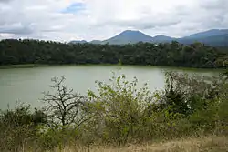
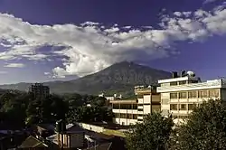 The view of Mount Meru from Arusha. The picture is facing towards north east direction. | |
 | |
| Country | Tanzania |
| Zone | Northern |
| Capital | Arusha |
| Government | |
| • Regional Commissioner | Iddi Kimanta |
| Area | |
| • Total | 37,576 km2 (14,508 sq mi) |
| • Land | 33,809 km2 (13,054 sq mi) |
| • Water | 707 km2 (273 sq mi) |
| Population (2012) | |
| • Total | 1,694,310 |
| • Density | 45/km2 (120/sq mi) |
| Time zone | UTC+3 (EAT) |
| Postcode | 23xxx |
| Area code(s) | 027 |
| HDI (2018) | 0.545[1] low · 9th of 25 |
| Website | City Website |
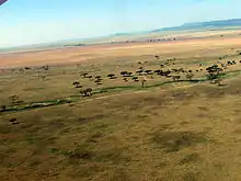
Arusha Region is a tourist destination and is the center of the northern Tanzania safari circuit. The national parks and reserves in this region include Ngorongoro Conservation Area, Arusha National Park, the Loliondo Game Controlled Area, and part of Lake Manyara National Park. Remains of 600-year-old stone structures are found at Engaruka, just off the dirt road between Mto wa Mbu and Lake Natron. With a HDI of 0.721, Arusha is one among the most developed regions of Tanzania.[3]
History
Much of the present area of Arusha Region used to be Maasai land. The Maasai are still the dominant community in the region.[4] Their influence is reflected in the present names of towns, regional culture, cuisine, and geographical features.
The administrative region of Arusha existed in 1922[5] while mainland Tanzania was a British mandate under the League of Nations and known as Tanganyika. In 1948, the area was in the Northern Province,[6] which includes the present day regions of Manyara and Kilimanjaro. In 1966, under the newly independent Tanzanian government, Arusha was given its own regional status.[5]
In 2002, Manyara Region was created and was split from Arusha Region. Portions of the former Arusha Region districts of Kiteto, Babati, Mbulu, Hanang, and a tiny piece of Monduli were incorporated into the Manyara Region.
Arusha was the largest region in Tanzania from 1966-2002.[7]
Geography
The Great Rift Valley runs through the middle of the region north-to-south. Oldonyo Lengai (Mountain of God in the Maasai language) is an active volcano to the north of the Ngorongoro Conservation Area. Altitudes throughout the region vary widely, but much of it ranges from 900 to 1,600 metres (3,000 to 5,200 ft) in elevation.[4]
Mount Meru, the second highest mountain in Tanzania after Mount Kilimanjaro, peaks at 4,655 metres (15,272 ft). Arusha Region has the highest number of craters and extinct volcanoes in Tanzania.[4] Other geographical features include the Monduli Mountains, Mount Loolmalasin, Mount Longido, and the Olduvai Gorge.
The city of Arusha, the capital of the region, is located at the southern foot of Mount Meru. The majority of Arusha residents live in the city and the surrounding southeastern part of Arusha Region.
Districts
Arusha Region is divided into one city and six districts, each administered by a council.[8]
| Districts of Arusha Region | ||||||
|---|---|---|---|---|---|---|
| Map | District | Capital | Population (2012) |
Area (km²) | ||
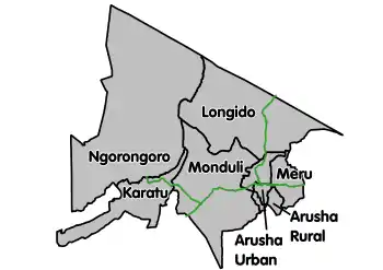 |
Arusha City | Arusha | 416,442 | 93 | ||
| Arusha Rural District* | Arusha | 323,198 | 1,547.6[9] | |||
| Karatu District | Karatu | 230,166 | 3,300 | |||
| Longido District | Longido | 123,153 | 7,782 | |||
| Meru District** | Usa River | 268,144 | 1,268.2[10] | |||
| Monduli District | Monduli | 158,929 | 6,419 | |||
| Ngorongoro District | Loliondo | 174,278 | 14,036 | |||
| Total | Arusha | 1,694,310 | 34,526 | |||
Notes:
* - representing the west portion of the former Arumeru District
** - representing the east portion of the former Arumeru District
National parks, national monuments, and other sites


- Arusha National Park
- Empakaai Crater
- Engaruka
- Great Rift Valley
- Lake Manyara National Park (part)
- Mount Longido Forest Reserve
- Mount Meru Forest Reserve
- Ngorongoro Conservation Area
- Ngurdoto Crater
- Oldonyo Lengai
- Olduvai Gorge
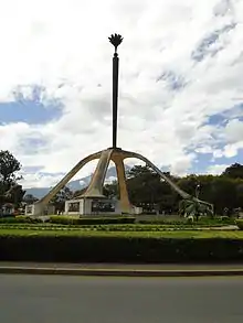
- Uhuru Monument
Demographics
According to the 2012 national census, the Arusha Region had a population of 1,694,310.[11]
The region is inhabited by various ethnolinguistic groups and communities. Among these are the Iraqw, Arusha, Maasai, Wameru, Sonjo, Chagga, Pare, and Nguu.[12]
Culture and cuisine
Nyama Choma, the northern Tanzanian barbecue, is a popular dish among some communities in the Arusha Region, particularly the Maasai.[13] Nyama Choma is properly served with a side of french fries, Pili Pili sauce and a cold local beer or soda.

Transportation
Roads
The A-23 Arusha-Himo road runs east-west and enters the region near Kilimanjaro International Airport. It connects Arusha with Moshi and then Himo at the Kenyan border. This roads ends at its junction with the A-104 road in the center of Arusha.
The A-104 runs northward, to the west of Mount Meru, from Arusha to Longido and Namanga at the Kenyan border before continuing to Nairobi. The A-104 also runs westward past Monduli to its junction at Makuyuni with the B-144 road that leads to Mto wa Mbu and the Ngorongoro Conservation Area. After that, the A-104 curves southward to the east of Lake Manyara and continues on to Babati and Dodoma.
Most overland travel is done by bus from the city of Arusha. Within the city and smaller towns, privately owned and operated dala-dalas (mini-buses) are used.
Waterways
The region is landlocked, and there are no navigable rivers. The larger lakes in the Rift Valley are not used for transportation. The region is home to Lake Eyasi, Lake Natron, Lake Duluti, Lake Empakaai, and the Momella lakes.
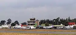
Airports
Arusha Region is served by the Kilimanjaro International Airport located in Hai District of Kilimanjaro Region. Its twelve international carriers are;
- Airkenya Express
- Air Uganda
- Condor
- Edelweiss Air
- Ethiopian Airlines
- Kenya Airways
- KLM
- Precision Air
- Qatar Airways
- RwandAir
- Safarilink Aviation
- Turkish Airlines
The smaller Arusha Airport (Kisongo Airport) serves small, medium and personal planes mainly to popular tourist areas such as Serengeti National Park, Seronera, Ndutu, Zanzibar etc. Planes using Kisongo Airport include;
- AMREF
- Auric Air
- Coastal Air
- Flying Doctors
- Grumeti Air
- Other personal planes.
- Precision Air
- TFC
Notable people
- Filbert Bayi grew up in the Arusha Region.
- Edward Sokoine Tanzania's second prime minister
- Edward Lowassa Tanzania's tenth prime minister from 2005-2008
- Frederick Sumaye Tanzania's ninth prime minister from 1995-2005
Regional commissioners
The chief administrative officer of the region is the regional commissioner. Below is a table showing the regional commissioners serving the Arusha region from 1962 to present:[14]
| Name of Regional Commissioner | From | To | Comments |
|---|---|---|---|
| Edward Barongo | 1962 | 1962 | first after independence |
| Peter Walwa | 1962 | 1963 | |
| Samuel Chamshama | 1963 | 1964 | first after union with Zanzibar |
| John Mhaville | 1964 | 1964 | second term |
| Wazir Juma | 1964 | 1968 | |
| Aaron Mwakangata | 1968 | 1973 | |
| Abdulanur Suleiman | 1973 | 1978 | |
| Peter Siyovelwa | 1978 | 1981 | |
| John Mhaville | 1981 | 1982 | |
| Charles Kileo | 1983 | 1985 | |
| Christopher Liundi | 1985 | 1987 | |
| Augustine Mwingira | 1987 | 1990 | |
| Anatoly Tarimo | 1990 | 1992 | |
| Ahmed Kiwanuka | 1992 | 1995 | |
| Daniel Ole Njoolay | 1995 | 2003 | longest serving commissioner |
| Mohammed Babu | 2003 | 2006 | |
| Abbas Kandoro | 2006 | 2006 | less than six months |
| Samuel Ndomba | 2006 | 2007 | [15] |
| Isidore Leka Shirima | 2007 | 2011 | [16] |
| Magesa Stanslaus Mulongo | 2011 | 2014 | [17][18] |
| Daudi Felix Ntibenda | 2014 | 2016 | |
| Mrisho Gambo | 2016 | 2020[19] | |
| Idd Hassan Kimanta | 2020[20] |
See also
References
- "Sub-national HDI - Area Database - Global Data Lab". hdi.globaldatalab.org. Retrieved 2020-02-26.
- 32,131 km2 (12,406 sq mi) for Maryland at "Land and Water Area of States and Other Entities" (PDF). Bureau of the Census. 2008. Archived from the original (PDF) on 17 October 2011. Retrieved 10 April 2013.
34,506 km2 (13,323 sq mi) for Arusha. - http://hdr.undp.org/sites/default/files/thdr2014-main.pdf
- "Weather of Ngorongoro Conservation Area - ngorongoro weather". Ngorongoro Crater Tanzania. 2019-08-13. Retrieved 2020-08-05.
- "Regions of Tanzania", Statoids
- "Demographic Yearbook", Statistical Office, Department of Economic and Social Affairs, United Nations, Seventh Issue, page 153, New York, 1955
- http://www.sido.go.tz/file/1676/download?token=VX6jaLf_
- "Arusha Region - Councils". Arusha Region Office, Tanzania. Archived from the original on 16 October 2016. Retrieved 4 November 2016.
- "Arusha District Council". Arusha Region Office, Tanzania. Archived from the original on 16 October 2016. Retrieved 4 November 2016.
- "Meru District Council". Arusha Region Office, Tanzania. Archived from the original on 9 April 2016. Retrieved 4 November 2016.
- Population Distribution by Administrative Units, United Republic of Tanzania, 2013, page 1 Archived May 2, 2013, at the Wayback Machine
- "Arusha Region Socio-Economic Profile", United Republic of Tanzania, joint publication of the Planning Commission Dar es Salaam and Regional Commissioner's Office Arusha, April 1998, page 3
- Centre, UNESCO World Heritage. "Ngorongoro Conservation Area". UNESCO World Heritage Centre. Retrieved 2020-08-05.
- Nkwame, Valentine Marc (9–15 December 2006). "Njoolay longest serving RC in Arusha: 17 RCs have served Arusha in 45 years". The Arusha Times (449). Archived from the original on 23 September 2015. Retrieved 4 September 2012.
- Col. Samuel Ndomba was reassigned to military duties in Dar es Salaam. Selasini, Edward (1–7 September 2007). "Zanzibar legislators visit Wazee Club". The Arusha Times (484). Archived from the original on 4 March 2016. Retrieved 4 September 2012.
- Staff reporter (1–7 September 2007). "Shirima at the helm of Arusha region". The Arusha Times (484). Archived from the original on 23 September 2015. Retrieved 4 September 2012.
- Arusha Times Correspondent (17 December 2011 – 13 January 2012). "RC guarantees order and tranquility". The Arusha Times (695). Archived from the original on 23 September 2015. Retrieved 4 September 2012.
- "Kitabu cha Mawasiliano Serikalini, Tanzania Government Directory, 2012, page 154". Archived from the original on 2013-01-25. Retrieved 2013-07-26.
- Melleor, Grace. "MRISHO GAMBO ATENGULIWA KUWA MKUU WA MKOA". startv.co.tz. Retrieved 2020-08-05.
- "Orodha ya Wakuu wa Mikoa | Arusha Regional". www.arusha.go.tz. Retrieved 2020-08-05.