Kajiado County
Kajiado County is a county in the former Rift Valley Province of Kenya. As of 2019, Kajiado county spanned an area of 21,292.7 km2, with a recorded population of 1,117,840. [2] The county borders Nairobi and extends to the Tanzania border further south. The county capital is Kajiado town, but the largest town is Ongata Rongai. Its main tourist attraction is its wildlife.
Kajiado County | |
|---|---|
 Flag  Coat of arms | |
 Location in Kenya | |
| Country | |
| Formed | 4 March 2013 |
| Capital | Kajiado |
| Government | |
| • Governor | Joseph Ole Lenku |
| Area | |
| • Total | 21,292.7 km2 (8,221.2 sq mi) |
| Population (2019) | |
| • Total | 1,117,840[1] |
| Time zone | UTC+3 (EAT) |
| Website | kajiado.go.ke |
Demographics
Kajiado county has a total population of 1,117,840 people, of which 557,098 being male, 560,704 are females and 38 intersex people.There are 316,179 households with an average size of 3.5 person per household and a population density of 51 people per square kilometre.[3]
| Sub-county | Population |
|---|---|
| Isinya | 210,473 |
| Kajiado Central | 161,862 |
| Kajiado North | 306,596 |
| Kajiado West | 82,849 |
| Loitokitok | 191,846 |
| Mashuuru | 64,214 |
| Total | 1,117,840 |
Source[3]
Administration Units
Kajiado is subdivided into five sub-counties with 25 county assembly wards across the county.[4] All the five constituencies have 5 county assembly wards each. There are 17 divisions which is further subdivided into 101 locations and 212 sub-locations.[5]
| Sub County | Division | Location | Sub Location |
|---|---|---|---|
| Kajiado North | 4 | 30 | 72 |
| Kajiado Central | 5 | 35 | 69 |
| Isinya | 2 | 9 | 18 |
| Mashuru | 2 | 11 | 19 |
| Loitokitok | 4 | 16 | 34 |
| Total | 17 | 101 | 212 |
Source[6]
Political Leadership
Joseph Jama Ole Lenku is the governor serving his first term after being elected in 2017 on and is deputised by Martin Moshisho Martin.[7] Phillip Salau Mpaayeiwas is serving his first term as the senator and was elected in 2017.[8] Janet Marania Teyiaa is the second women representative for the county and was also elected in 2017 on a Jubilee Party ticket.[9][10]
Education
Kajiado has 811 ECD centres, 568 primary schools, 124 secondary schools, 18 tertiary institutions and 7 polythenic.[6]
| Category | Public | Private | Total | Enrolment |
|---|---|---|---|---|
| ECD Centres | 423 | 388 | 811 | 24,631 |
| Primary schools | 372 | 186 | 568 | 158,064 |
| Secondary schools | 71 | 53 | 124 | 24,709 |
| Youth Polytechnics | 7 | 0 | 7 | |
| Technical Training Institutes | 7 | 0 | 7 | |
| University Campuses | 1 | 5 | 6 | |
| Universities | 5 | 5 |
Source[11]
Health
The doctor population ratio is 1:26,094, Public Health Staff is 1: 7,619, and the nurse population ratio is 1: 1,068.[12]
| Government | FBO | Private | NGO | TOTAL | |
|---|---|---|---|---|---|
| Hospitals | 4 | 1 | 10 | 16 | 41 |
| Health centres | 16 | 6 | 20 | 3 | 45 |
| Dispensaries | 74 | 13 | 4 | 2 | 93 |
| Clinics | 1 | 2 | 149 | 7 | 159 |
Source[11]
Transport and Communication
A total of 2,419.2 km of road network cover the county. of this 1,111.9 km ic covered by earth surface, 932.3 km is murram surface and 375 km is covered by bitumen.[13]
There are 11 Post Offices with 4,105 installed letter boxes, 3,220 rented letter boxes and 885 vacant letter boxes.[6]
.
Trade and Commerce
There are one hundred trading centres in the county.
Tomato, Cabbage, Kales and Banana are mainly grown for horticulture production. Crops grown for cereal production include maize, sorghum millet, beans, cowpeas and greengrams. Some of the tubers grown are sweet potatoes, cassava, Irish potatoes.
The three main livestock kept are cattle, sheep, goats and they are kept for meat, offal, raw fats, fresh hides and skins.[14]
Services
| County | Stats for the County (Percent) | ||||||||
|---|---|---|---|---|---|---|---|---|---|
| Literacy | 55.4 | ||||||||
| Attending School (15-18 Yrs) | 44.9 | ||||||||
| Paved Roads | 5.9 | ||||||||
| Good Roads | 38.4 | ||||||||
| Electricity Access | 39.8 | ||||||||
|
Stats for the County | |||||||||
Source: USAid Kenya
Nairobi Metro

Kajiado County is within Greater Nairobi metro.[15][16] The counties are:
| Area | County | Area (km2) | Population Census 2019 | Cities/towns/municipalities in the county |
|---|---|---|---|---|
| Core Nairobi | Nairobi County | 694.9 | 4,397,073 | Nairobi |
| Northern Metro | Kiambu County | 2,449.2 | 2,417,735 | Kiambu, Thika, Limuru, Ruiru, Karuri, Kikuyu |
| Southern Metro | Kajiado County | 21,292.7 | 1,117,840 | Kajiado, Olkejuado, Bissil, Ngong, Kitengela, Kiserian, Ongata Rongai |
| Eastern Metro | Machakos County | 5,952.9 | 1,421,932 | Kangundo-Tala, Machakos, Athi River |
| Totals | Nairobi Metro | 30,389.7 | 9,354,580 |
Source: NairobiMetro/ Kenya Census
Stats
Population development
| Year | Pop. | ±% |
|---|---|---|
| 1979 | 149,005 | — |
| 1989 | 258,659 | +73.6% |
| 1999 | 406,054 | +57.0% |
| 2009 | 687,312 | +69.3% |
| 2019 | 1,117,840 | +62.6% |
| source:[17] | ||
Urbanisation
| County | Urbanisation in Nairobi Metro (Percent) | ||||||||
|---|---|---|---|---|---|---|---|---|---|
| Nairobi County | 100 | ||||||||
| Kiambu County | 60.8 | ||||||||
| Machakos County | 52 | ||||||||
| Kajiado County | 41.4 | ||||||||
32.3 | |||||||||
|
Urbanisation by County within Nairobi Metro | |||||||||
Source: OpenDataKenya
Wealth/Poverty Level
| County | Poverty Level in Nairobi Metro (Percent) | ||||||||
|---|---|---|---|---|---|---|---|---|---|
| Kajiado County | 11.6 | ||||||||
| Kiambu County | 21.8 | ||||||||
| Nairobi County | 22 | ||||||||
| Machakos County | 59.6 | ||||||||
45.9 | |||||||||
|
Poverty level by County | |||||||||
Source: OpenDataKenya Worldbank
See also
- Amboseli Reserve is in the Kajiado County
- Nyiri Desert, a high proportion of the county lies in the desert
- Kitengela, a plain and a town of the same name in Kajiado County
See also
References
- "Kenya Census 2009 - Census - Kenya". Retrieved 20 April 2018 – via Scribd.
- "Kenya Districts". www.statoids.com. Retrieved 20 January 2021.
- Munene, Evans (4 November 2019). "2019 Kenya Population and Housing Census Results". Kenya National Bureau of Statistics. Retrieved 27 May 2020.
- "The Report of the Interim Independent Boundaries Review Commission (IIBRC): Delimitation of Constituencies and Recommendations on Local Authority Electoral Units and Administrative Boundaries for Districts and Other Units" (PDF). IEBC. Retrieved 27 May 2020.
- interior_admin. "Ministry of Interior and Coordination of National Government". interior.go.ke. Retrieved 27 May 2020.
- "Publications". Kenya National Bureau of Statistics. Retrieved 27 May 2020.
- "Governors & Deputy Governors". cog.go.ke. Retrieved 27 May 2020.
- "Members of the Senate | The Kenyan Parliament Website". www.parliament.go.ke. Retrieved 27 May 2020.
- "Women Representatives | KEWOPA KENYA". Retrieved 27 May 2020.
- "Janet Marania Teyiaa". Mzalendo. Retrieved 27 May 2020.
- "Education, Vocational Training, Youth and Sports – County Government of Kajiado". Retrieved 27 May 2020.
- "Kajiado County Integrated Development Plan CIDP 2018-2022". Kajiado County Government. Retrieved 27 May 2020.
- "Kenya Rural Roads Authority". www.kerra.go.ke. Retrieved 28 May 2020.
- "Agriculture, Livestock Veterinary Services & Fisheries – County Government of Kajiado". Retrieved 27 May 2020.
- http://196.200.27.243:8080/xmlui/bitstream/handle/123456789/111/Nairobi.pdf?sequence=3%5B%5D
- http://www.nairobimetro.go.ke/index.php?option=com_docman&task=doc_download&gid=43&Itemid=90%5B%5D.
- Kenya: Administrative Division population statistics
External links
- https://web.archive.org/web/20060518005113/http://www.kajiado-district-dev-trust.org.uk/
- https://web.archive.org/web/20070402092415/http://www.kajiadochildrenshome.com/
Nairobi metropolitan area | ||
|---|---|---|
Population - 7.8 million | ||
| Counties | 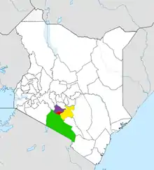 | |
| Major city 3.8 million | ||
| Urban Centres over 200K | ||
| Other major Urban Centres | ||
| Future developments | ||