Ash, Surrey
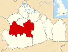
Ash is a village and civil parish in the far west of the borough of Guildford, Surrey. Ash is on the eastern side of the River Blackwater, with a station on the Reading-Guildford-Gatwick line, and direct roads to Aldershot, Farnham and Guildford. The 2011 census counted the residents of the main ward of Ash, which excludes Ash Vale, as 6,120.[n 1][1] It is within the Aldershot Urban Area (the Blackwater Valley) and adjoins the riverside in the east of that large town; Ash has a small museum in the local cemetery chapel, a large secondary school and a library.
| Ash | |
|---|---|
| Village | |
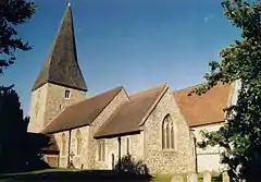
 St Peter's Church | |
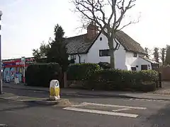
 Ash Post Office | |
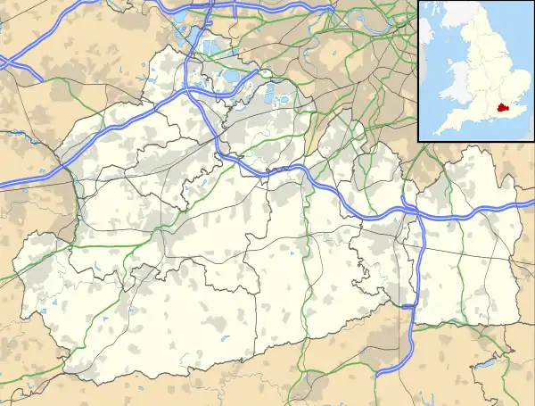
 Ash Location within Surrey | |
| Area | 9.74 km2 (3.76 sq mi) |
| Population | 17,166 (Civil Parish including Ash Vale)[1] |
| • Density | 1,762/km2 (4,560/sq mi) |
| OS grid reference | SU893516 |
| District | |
| Shire county | |
| Region | |
| Country | England |
| Sovereign state | United Kingdom |
| Post town | Aldershot |
| Postcode district | GU12 |
| Dialling code | 01252 |
| Police | Surrey |
| Fire | Surrey |
| Ambulance | South East Coast |
| UK Parliament | |
Localities
The southern part of the parish, including St. Peter's Church and Ash village, is on the London Clay; but the greater portion, once including Frimley, covers the western side of the ridge of Bagshot Sands, which is divided from Chobham Ridges by the dip through which the Basingstoke Canal and railway run, and is known as Ash Common, Fox Hills and Claygate Common (now in Surrey Wildlife Trust and MoD use).[n 2][2]
Ash Green
Ash Green is the community closer to the Hog's Back, along which the east-west A31 runs, and has Whitegate Copse and arable fields as a green buffer on all sides.
The hamlet used to be served by Ash Green Halt. The railway station had two platforms and was situated on the Tongham branch of the Alton line before passenger services were withdrawn in 1937 along with Tongham station and ultimately the branch closed in 1960. Though the tracks have been long removed, the stretch of land from Tongham through Christmas Pie, where the route of the branch line still exists, is a popular attraction for cyclists and walkers. Ash Green Halt's station building, complete with its Southern Railway-style sign, still stands and has been converted into a house.[3]
History
From the prehistoric period, a few neolithic implements have been found and these are now in the Surrey Archaeological Society's Museum at Guildford.[2]
There is no mention of a mill under Henley in Domesday Book, but it is certain that a mill existed at Ash from comparatively early times, for in 1322 the Abbot of Chertsey ordered a new windmill to be built at Ash. Windmills were comparatively new in England then, and it may have been in place of a small water-mill of earlier date. There seems no later record of it.[2]
The two manors existed. Ash (Esche, 7th century; Asshe, Assche, 14th century) shares with the other a prominent social history starting with at least the Norman period of the Domesday book whose commissioners wrote "Azor granted [part of Henley known as Ash] for his soul to Chertsey in the time of King William. Later a 1279 chartulary of Chertsey Abbey records the prohibition of any perpetual title of institutions (as the Abbey states, vulgarly called the prohibition of mortmain) as led here to 11 acres in Ash with sufficient common pasture for his flocks and herds being held by Robert de Zathe, while Geoffrey de Bacsete (Bagshot) and his brother William had 28 acres. The Atwaters of West Clandon also held land in Ash. Nonetheless, from the church's freehold, overall control passed from 1537 in the Dissolution of the Monasteries to Winchester College. Henley, also seen as Henle, (14th century) and Suth henle and Henle on the Heth usually to distinguish Henley on Thames has hosted a long list of prominent figures. The de Henley, de Molyns [n 3], the crown as owner from Edward I to Charles I, Arthur Squib whose daughter married its next owner John Glynne, occupied briefly by the Duke of Roxburgh then via Glynne's granddaughter's husband, Sir Richard Child, created Earl of Tylney it then passed to ambassador and diplomat Solomon Dayrolles, upon whose death John Halsey bought it, whose family owned it from the 18th to 20th centuries.
The church is dedicated to St Peter, which distinguishes it from the other English places named Ash; Ash, in Kent, near Dartford, has a church to St Peter and St Paul.
Declared a parish, under Gilbert's Act, Ash was partly in the hundred of Godley and partly in Woking Hundred. It included in 1848 Frimley (a chapelry) and Normandy tything so altogether at that time had 2,236 inhabitants. The parish was and is intersected by the Basingstoke Canal and a branch of the South Western Main Line and comprised, with Normandy in, about 4,000 acres (1,600 ha), of which 2,041 acres (826 ha) were common or waste, see geology under Surrey, i.e. wet lowland heath; (and including Frimley, about 10,015 acres). The soil of Ash yielded sandstone, dug from its common, used for building for centuries; and:
[Locally] pebbles are found, susceptible of a bright polish, which are commonly called Bagshot diamonds. The village is long and scattered, and situated in a dreary part of the country: south-eastward of it is Henley Park, which, being on an eminence, forms a beautiful contrast with the wild heath around. The living is a rectory, valued in the king's books [for land tax liability] at £15. 18. 11½.; net income, £473; patrons, the Warden and Fellows of Winchester College. The church [before] the dissolution of monasteries, was attached to the abbey of Chertsey... Dr. Young is said to have written a portion of the Night-Thoughts at the rectory-house, then the residence of Dr. Harris, who married a sister of the poet, and was incumbent from 1718 to 1759.[4]
Young's poem is particularly noted for original adages such as "procrastination is the thief of time". Wyke near Worplesdon was added to the parish in 1880,[2] however has changed parish council to that of Normandy.[5]
Significant homes and listed buildings
In 1911 Henley Park, and two houses in Normandy were recorded as significant historic homes.[2]
Henley Park estate can be traced back to the Domesday Book, when it was held by Azor, one of the guards of Edward the Confessor. The land was later owned by Chertsey Abbey, who leased it to the de Henley family. The estate passed through many hands, including the English Civil War rebel, John Glynne MP. Later tenants included Lord Pirbright, who entertained King Edward VII, and Sir Owen and Lady Roberts. During World War I, the house was used as an auxiliary hospital, and in the mid 20th century the estate was developed as a factory. It has since been restored to residential use.
The following listed buildings can be found in the village:
|
|
Education
In education, Ash has:
- Ash Grange School
- Walsh (C of E) School
- Shawfield School
- Ash Manor School which is county supported and has 937 students aged 11–16.[20]
A museum occupies much of the large cemetery chapel.[21] There is a Surrey County Council library in the village with a helpdesk to assist also with the most common Guildford borough council services.
Youth outreach
The Normandy Youth Club sponsors community-based programs targeting youth in the area (especially marginal groups and minorities) for the purpose of increasing exposure to educational opportunities and building community cohesion.[22] Since the closure of 2nd Ash Scout Group in 2010, 1st Ash Vale is the only local Scout group in Ash (for Beavers, Cubs and Scouts), and the Local Explorer Scout group is Hybrid Explorer Scouts.
Sport and leisure
Ash United is the local football club, which currently plays in the Combined Counties League Division 1. The club is on Youngs Drive, opposite Shawfield Park.
Transport
There is a frequent bus service through Ash, 'The Kite', linking Ash to Guildford and Aldershot. There are other, less frequent, bus services connecting to Farnborough, and Camberley. The parish is also served by Ash Vale station with a direct London Waterloo service and the Guildford to Ascot line along with Ash and North Camp stations, both located within the parish, with direct services to Reading, Guildford, Redhill and Gatwick. The Basingstoke Canal passes through the north of the village.
Famous residents
- of Ashe Grange:
- Frederick Hammersley, owner[23]
- of Henley Park (house):
- John Glynne, owner
- Solomon Dayrolles, diplomat, owner
- Henry de Worms, 1st Lord Pirbright, Under-Secretary of State for the Colonies, tenant
- Sir Owen Roberts, pioneer of technical education, tenant
- James Wade
- Andy Lane, author of Doctor Who and Young Sherlock Holmes novels lived in Ash for 11 years
Demography and housing
The proportion of households in Ash Wharf, the central ward, who owned their home outright was 1.3% above the regional average. The proportion who owned their home with a loan was 3.7% above the regional average; providing overall a marginally lower proportion than average of rented residential property relative to that in Surrey, the district and the national average.
| Output area | Population | Households | % Owned outright | % Owned with a loan | hectares[1] |
|---|---|---|---|---|---|
| Ash Wharf (ward) | 6,120 | 2,578 | 33.8 | 38.8 | 322[1] |
| Output area | Detached | Semi-detached | Terraced | Flats and apartments | Caravans/temporary/mobile homes | Shared between households[1] |
|---|---|---|---|---|---|---|
| (Civil Parish) | 2,090 | 2,619 | 1,536 | 1,027 | 56 | 2 |
The average level of accommodation in the region composed of detached houses was 28%, the average that was apartments was 22.6%.
Politics
Ash is in Surrey Heath constituency, which since its inception been won by the Conservative party. Local government is administered by Guildford Borough Council and Surrey County Council.
At Surrey County Council, one of the 81 representatives represents the area within the Ash division.[24]
At Guildford Borough Council two wards are deemed appropriate, represented under the current constitution by two to three councillors.[25]
| Election | Member[25] |
Ward | |
|---|---|---|---|
| 2011 | Nick Sutcliffe | Ash South and Tongham | |
| 2013 | Paul Spooner | Ash South and Tongham | |
| 2011 | Stephen Mansbridge | Ash South and Tongham | |
| 2013 | Murray Grubb Jnr | Ash Wharf | |
| 2011 | Jayne Hewlett | Ash Wharf | |
| Election | Member[26] |
Electoral Division | |
|---|---|---|---|
| 2013 | Marsha Moseley | Ash | |
Localities
Notes and references
- notes
- Based on the main area of Ash Wharf (one of the wards of the United Kingdom) covering 3.22 km² whereas the Civil Parish had in 2011 a population of 17,549.[1]
- Claygate Common in Ash is not to be confused with Claygate in the KT10 Esher postcode, Surrey
- whose right unusually had included the right of erecting gallows on the soil of the manor, and of passing judgement on malefactors apprehended there; see also Chobham Common regarding highwaymen[2]
- references
- Key Statistics; Quick Statistics: Population Density Archived 11 February 2003 at the Wayback Machine United Kingdom Census 2011 Office for National Statistics Retrieved 21 November 2013
- H.E. Malden (editor) (1911). "Parishes: Ash". A History of the County of Surrey: Volume 3. Institute of Historical Research. Archived from the original on 19 December 2011. Retrieved 24 October 2012.CS1 maint: extra text: authors list (link)
- Ralph Rawlinson. "Arvans, St – Ashburton". Station Name: ASH GREEN HALT. Archived from the original on 27 September 2013. Retrieved 25 September 2013.
- Samuel Lewis (editor) (1848). "Arvans, St – Ashburton". A Topographical Dictionary of England. Institute of Historical Research. Archived from the original on 4 November 2012. Retrieved 24 October 2012.CS1 maint: extra text: authors list (link)
- "Ash Parish Council". Archived from the original on 3 September 2012. Retrieved 10 June 2012.
- St Peter's Church Historic England. "Details from listed building database (1029647)". National Heritage List for England. Retrieved 24 October 2012. with the Parker Chest Tomb
- Azar Place Historic England. "Details from listed building database (1029648)". National Heritage List for England. Retrieved 24 October 2012.
- Tudor House Historic England. "Details from listed building database (1029649)". National Heritage List for England. Retrieved 24 October 2012.
- Ashe Grange Historic England. "Details from listed building database (1029650)". National Heritage List for England. Retrieved 24 October 2012.
- Oast House, Stable Historic England. "Details from listed building database (1029651)". National Heritage List for England. Retrieved 24 October 2012.
- Barn Historic England. "Details from listed building database (1029652)". National Heritage List for England. Retrieved 24 October 2012.
- York House Historic England. "Details from listed building database (1029653)". National Heritage List for England. Retrieved 24 October 2012.
- Hartshorn Historic England. "Details from listed building database (1188299)". National Heritage List for England. Retrieved 24 October 2012.
- 92 Ash Street Historic England. "Details from listed building database (1188315)". National Heritage List for England. Retrieved 24 October 2012.
- Ashmead House Historic England. "Details from listed building database (1188335)". National Heritage List for England. Retrieved 24 October 2012.
- Merryworth Historic England. "Details from listed building database (1188338)". National Heritage List for England. Retrieved 24 October 2012.
- Ash Manor / Old Manor Cottage Historic England. "Details from listed building database (1294794)". National Heritage List for England. Retrieved 24 October 2012.
- The Post Office Historic England. "Details from listed building database (1294827)". National Heritage List for England. Retrieved 24 October 2012.
- Memorial Chapel Historic England. "Details from listed building database (1390713)". National Heritage List for England. Retrieved 24 October 2012.
- Ash Manor School
- Ash museum history Archived 18 August 2007 at the Wayback Machine
- Award for Mother Who Transformed Her Village Archived 24 October 2010 at the Wayback Machine; 18 October 2010 article; Get Surrey the website of the Surrey Advertiser and Surrey Herald; retrieved 30 January 2013.
- 1901 England Census for Frederick Hammersley, Surrey, Ash: Ancestry.com {[subscription}}
- Electoral Divisions Archived 2 December 2013 at the Wayback Machine Surrey County Council. Retrieved 21 November 2013
- Your local councillors Archived 29 October 2013 at the Wayback Machine Guildford Borough Council. Retrieved 21 November 2013
- Your Councillor Archived 7 December 2013 at the Wayback Machine Surrey County Council. Retrieved 6 November 2013
- Jenkinson, S. (1990). Ash and Ash Vale – A Pictorial History, Chichester: Phillimore. ISBN 0-85033-773-9.
External links
| Wikimedia Commons has media related to Ash, Surrey. |
- Ash Residents Association
- Ash Parish News
- Ash Parish Council
- Old photos
- Ash WWI roll of honour
- Ash WWII roll of honour
- Stained Glass Windows at St. Peter Ash, Surrey
- Stained Glass Windows at Store (former chapel) Ash, Cemetery, Surrey
- Surrey County Council. "Ash". Exploring Surrey's Past. Retrieved 24 May 2017.
