Atalaia do Norte
Atalaia do Norte is the most western municipality in the Brazilian state of Amazonas. Its population was 20,398 (2020) and its area is 76,355 km²,[3] thus making it the third largest municipality in Amazonas and the seventh largest in Brazil. It is in the area of this municipality that find the Vale do Javari, an indigenous reserve that is inhabited until the present day by isolated indians also called "arrow peoples", indigenous ethnic groups that have had little or no contact with modernity.[4]
Atalaia do Norte | |
|---|---|
Municipality | |
| The Municipality of Atalaia do Norte | |
 Flag  Seal | |
| Nickname(s): "Pérola do Javari" (Javari's Pearl) | |
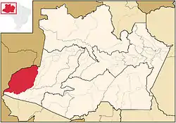 Location in the Estado do Amazonas | |
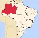
 Atalaia do Norte Location in Brazil | |
| Coordinates: 04°22′19″S 70°11′31″W | |
| Country | |
| Region | Norte |
| State | |
| Founded | December 19, 1955 |
| Government | |
| • Mayor | Nonato do Nascimento Tenazor (PDT) |
| Area | |
| • Total | 76,355 km2 (29,481 sq mi) |
| Elevation | 65 m (213 ft) |
| Population (2020) | |
| • Total | 20,398 |
| • Density | 0.17/km2 (0.4/sq mi) |
| [1] | |
| Time zone | UTC-5 (EST) |
| HDI (2000) | 0.559 – medium[2] |
References
- IBGE 2020
- "Archived copy". Archived from the original on 2009-10-03. Retrieved 2009-12-17.CS1 maint: archived copy as title (link) UNDP
- IBGE - "Archived copy". Archived from the original on 2008-06-11. Retrieved 2008-06-11.CS1 maint: archived copy as title (link)
- PHILLIPS, Tom (2011-06-22). "Uncontacted tribe found deep in Amazon rainforest". The Guardian UK. Retrieved 2020-05-08.
Capital: Manaus | ||||||||||||||
| Mesoregion Centro Amazonense |
|  | ||||||||||||
| Mesoregion Norte Amazonense |
| |||||||||||||
| Mesoregion Sudoeste Amazonense |
| |||||||||||||
| Mesoregion Sul Amazonense |
| |||||||||||||
This article is issued from Wikipedia. The text is licensed under Creative Commons - Attribution - Sharealike. Additional terms may apply for the media files.