Manacapuru
Manacapuru (Munychapur) is a municipality located in the Brazilian state of Amazonas.
Manacapuru | |
|---|---|
 Flag  Seal | |
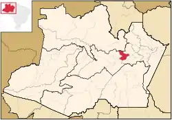 Location of the municipality inside Amazonas | |
| Coordinates: 3°17′59″S 60°37′14″W | |
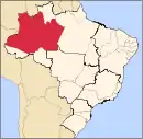
| Country | |
| Region | North |
| State | |
| Founded | July 16, 1932 |
| Government | |
| • Mayor | Betanael da Silva Dangelo (PROS) |
| Area | |
| • Total | 7,329.234 km2 (2,829.833 sq mi) |
| Elevation | 25 m (82 ft) |
| Population (2020) | |
| • Total | 98,502 |
| • Density | 12.85/km2 (33.3/sq mi) |
| Time zone | UTC−4 (BRT) |
| • Summer (DST) | UTC−4 (DST no longer used) |
Population
The population of Manacapuru was 98,502 (2020)[1] and its area is 7,329 km².[2] The city is one of the biggest in the state. It is located about 80 km (50 mi) upstream (west) from Manaus, at the point where the Manacapuru River flows into the Solimões River.
Main sights
The municipality contains about 19% of the Rio Negro Right Bank Environmental Protection Area, a 1,140,990 hectares (2,819,400 acres) sustainable use conservation unit that controls use of an area of Amazon rainforest along the Rio Negro above the junction with the Solimões River.[3] It also contains about 4% of the Rio Negro Sustainable Development Reserve, a 103,086 hectares (254,730 acres) sustainable use conservation unit created in 2008 in an effort to stop deforestation in the area, which is threatened due to its proximity to Manaus.[4]
Notable people
- Marcelinho – Footballer, playing for the Bulgarian national football team.
References
- IBGE 2020
- Brazilian Institute of Geography and Statistics (IBGE) - "Archived copy". Archived from the original on 2007-01-09. Retrieved 2007-01-09.CS1 maint: archived copy as title (link)
- APA Margem Direita do Rio Negro (in Portuguese), ISA: Instituto Socioambiental, retrieved 2016-06-26
- RDS do Rio Negro (in Portuguese), ISA: Instituto Socioambiental, retrieved 2016-06-27
Capital: Manaus | ||||||||||||||
| Mesoregion Centro Amazonense |
|  | ||||||||||||
| Mesoregion Norte Amazonense |
| |||||||||||||
| Mesoregion Sudoeste Amazonense |
| |||||||||||||
| Mesoregion Sul Amazonense |
| |||||||||||||