Manicoré
Manicoré is a municipality located in the south-east of the Brazilian state of Amazonas.
Manicoré | |
|---|---|
Municipality | |
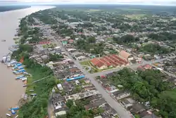 Manicoré town on the banks of the Madeira River | |
 Flag  Seal | |
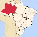
 Amazonas state with Manicore municipality in red | |
 Manicoré Location in Brazil | |
| Coordinates: 5°48′32″S 61°18′00″W | |
| Country | |
| Region | North |
| State | Amazonas |
| Government | |
| • Mayor | Manuel Sebastiao Pimentel Medeiros (PSD) |
| Area | |
| • Total | 48,282 km2 (18,642 sq mi) |
| Population (2020) | |
| • Total | 56,583 |
| Time zone | UTC-4 (UTC-4) |
Location
The population of Manicoré was 56,583 (2020)[1] and its area is 48,282 km².[2] The town is located on the banks of the Madeira River about 3 km (1.9 mi) downstream from where the Manicoré River merges into the Madeira.
The city is served by Manicoré Airport.
Economy
Santo Antônio do Matupí is a major centre of logging in the region.[3]
Conservation
The municipality contains the 304,146 hectares (751,560 acres) Lago do Capanã Grande Extractive Reserve, created in 2004.[4] It contains 15% of the 283,117 hectares (699,600 acres) Rio Madeira Sustainable Development Reserve, created in 2006.[5] It contains about 15% of the Campos Amazônicos National Park, a 961,318 hectares (2,375,470 acres) protected area created in 2006 that protects an unusual enclave of cerrado vegetation in the Amazon rainforest.[6] It contains about 10% of the 513,747 hectares (1,269,500 acres) Matupiri State Park, created in 2009 along the Matupiri River.[7] It contain 22% of the 397,557 hectares (982,380 acres) Igapó-Açu Sustainable Development Reserve, also created in 2009.[8]
The municipality contains about 55% of the 359,138 hectares (887,450 acres) Manicoré Biological Reserve, created by decree in May 2016 in the week before the provisional removal of president Dilma Rousseff.[9] The municipality also contains the 151,993 hectares (375,580 acres) Campos de Manicoré Environmental Protection Area, created at the same time. The purpose was to protect biological diversity and control the process of occupying the region, in particular along the road being built between Santo Antônio de Matupi on BR-230 and the seat of the municipality of Manicoré on the Madeira River.[10] The municipality contains about 9% of the 751,302 hectares (1,856,510 acres) Aripuanã National Forest, a sustainable development unit also created at that time.[11]
Climate
| Climate data for Manicoré (1981–2010, extremes 1967–present) | |||||||||||||
|---|---|---|---|---|---|---|---|---|---|---|---|---|---|
| Month | Jan | Feb | Mar | Apr | May | Jun | Jul | Aug | Sep | Oct | Nov | Dec | Year |
| Record high °C (°F) | 36.8 (98.2) |
37.0 (98.6) |
37.8 (100.0) |
36.6 (97.9) |
37.0 (98.6) |
36.8 (98.2) |
36.9 (98.4) |
39.8 (103.6) |
39.8 (103.6) |
38.8 (101.8) |
39.8 (103.6) |
37.3 (99.1) |
39.8 (103.6) |
| Average high °C (°F) | 32.0 (89.6) |
31.8 (89.2) |
32.1 (89.8) |
32.2 (90.0) |
32.0 (89.6) |
32.5 (90.5) |
33.3 (91.9) |
34.2 (93.6) |
34.0 (93.2) |
33.6 (92.5) |
33.1 (91.6) |
32.3 (90.1) |
32.8 (91.0) |
| Daily mean °C (°F) | 26.3 (79.3) |
26.3 (79.3) |
26.5 (79.7) |
26.6 (79.9) |
26.5 (79.7) |
26.4 (79.5) |
26.7 (80.1) |
27.0 (80.6) |
27.2 (81.0) |
27.2 (81.0) |
27.0 (80.6) |
26.6 (79.9) |
26.7 (80.1) |
| Average low °C (°F) | 22.8 (73.0) |
22.9 (73.2) |
22.9 (73.2) |
22.9 (73.2) |
22.8 (73.0) |
22.1 (71.8) |
21.8 (71.2) |
22.1 (71.8) |
22.7 (72.9) |
23.0 (73.4) |
23.1 (73.6) |
23.0 (73.4) |
22.7 (72.9) |
| Record low °C (°F) | 13.4 (56.1) |
13.6 (56.5) |
14.0 (57.2) |
13.6 (56.5) |
9.4 (48.9) |
11.0 (51.8) |
11.5 (52.7) |
12.0 (53.6) |
13.8 (56.8) |
13.0 (55.4) |
14.2 (57.6) |
14.0 (57.2) |
9.4 (48.9) |
| Average precipitation mm (inches) | 319.7 (12.59) |
347.9 (13.70) |
327.3 (12.89) |
315.9 (12.44) |
210.3 (8.28) |
101.0 (3.98) |
48.6 (1.91) |
60.5 (2.38) |
104.9 (4.13) |
199.6 (7.86) |
220.5 (8.68) |
266.7 (10.50) |
2,522.9 (99.33) |
| Average precipitation days (≥ 1.0 mm) | 20 | 19 | 20 | 19 | 17 | 10 | 6 | 6 | 9 | 13 | 14 | 18 | 171 |
| Average relative humidity (%) | 87.9 | 87.8 | 87.8 | 87.7 | 87.6 | 85.2 | 81.7 | 81.4 | 81.9 | 83.3 | 84.9 | 87.0 | 85.4 |
| Mean monthly sunshine hours | 106.9 | 87.5 | 93.5 | 110.9 | 135.8 | 182.4 | 232.8 | 186.6 | 156.5 | 143.5 | 134.4 | 112.3 | 1,683.1 |
| Source 1: Instituto Nacional de Meteorologia[12] | |||||||||||||
| Source 2: Meteo Climat (record highs and lows)[13] | |||||||||||||
References
- IBGE 2020
- Cidades Archived 2007-01-09 at the Wayback Machine, IBGE
-
- Brasil ganha cinco novas áreas protegidas no sul do Amazonas (in Portuguese), WWF Brasil, 16 May 2016, retrieved 2016-06-13
- RESEX do Lago do Capanã Grande (in Portuguese), ISA: Instituto Socioambiental, retrieved 2016-08-29
- RDS do Rio Madeira (in Portuguese), ISA: Instituto Socioambiental, retrieved 2016-09-01
- PARNA dos Campos Amazônicos (in Portuguese), ISA: Instituto Socioambiental, retrieved 2016-06-03
- PES do Matupiri (in Portuguese), ISA: Instituto Socioambiental, retrieved 2016-09-01
- RDS Igapó-Açu (in Portuguese), ISA: Instituto Socioambiental, retrieved 2016-09-02
- REBIO do Manicoré (in Portuguese), ISA: Instituto Socioambiental, retrieved 2016-06-14
- "Num de seus últimos atos, Dilma cria APA, Reserva e amplia floresta no Amazonas", A Critica (in Portuguese), Rede Calderaro de Comunicação, 12 April 2016, retrieved 2016-06-13
- FLONA do Aripuanã (in Portuguese), ISA: Instituto Socioambiental, retrieved 2016-06-15
- "Normais Climatológicas Do Brasil 1981–2010" (in Portuguese). Instituto Nacional de Meteorologia. Retrieved 4 November 2018.
- "Station Manicore" (in French). Meteo Climat. Retrieved 4 November 2018.
Capital: Manaus | ||||||||||||||
| Mesoregion Centro Amazonense |
|  | ||||||||||||
| Mesoregion Norte Amazonense |
| |||||||||||||
| Mesoregion Sudoeste Amazonense |
| |||||||||||||
| Mesoregion Sul Amazonense |
| |||||||||||||