Coper, Boyacá
Coper is a town and municipality in the Colombian Department of Boyacá, part of the subregion of the Western Boyacá Province.
Coper | |
|---|---|
Municipality and town | |
.svg.png.webp) Flag | |
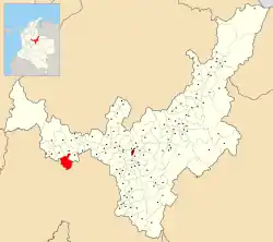 Location of the municipality and town of Coper in Boyacá | |
| Coordinates: 5°29′N 74°03′W | |
| Country | |
| Department | Boyacá |
| Province | Western Boyacá Province |
| Government | |
| • Mayor | Aurora del Carmen Nieto Molina (2020-2023) |
| Time zone | UTC-5 (Colombia Standard Time) |
Climate
Coper has a tropical rainforest climate (Af) with heavy to very heavy rainfall year-round.
| Climate data for Coper | |||||||||||||
|---|---|---|---|---|---|---|---|---|---|---|---|---|---|
| Month | Jan | Feb | Mar | Apr | May | Jun | Jul | Aug | Sep | Oct | Nov | Dec | Year |
| Average high °C (°F) | 28.3 (82.9) |
28.5 (83.3) |
28.6 (83.5) |
28.6 (83.5) |
28.4 (83.1) |
28.2 (82.8) |
29.0 (84.2) |
28.8 (83.8) |
28.4 (83.1) |
27.8 (82.0) |
27.6 (81.7) |
27.7 (81.9) |
28.3 (83.0) |
| Daily mean °C (°F) | 23.3 (73.9) |
23.6 (74.5) |
23.8 (74.8) |
24.1 (75.4) |
23.9 (75.0) |
23.5 (74.3) |
23.8 (74.8) |
23.6 (74.5) |
23.3 (73.9) |
23.2 (73.8) |
23.0 (73.4) |
23.0 (73.4) |
23.5 (74.3) |
| Average low °C (°F) | 18.4 (65.1) |
18.8 (65.8) |
19.1 (66.4) |
19.6 (67.3) |
19.4 (66.9) |
18.8 (65.8) |
18.7 (65.7) |
18.4 (65.1) |
18.3 (64.9) |
18.6 (65.5) |
18.4 (65.1) |
18.4 (65.1) |
18.7 (65.7) |
| Average rainfall mm (inches) | 207.7 (8.18) |
224.4 (8.83) |
312.7 (12.31) |
383.6 (15.10) |
350.1 (13.78) |
172.4 (6.79) |
114.5 (4.51) |
138.9 (5.47) |
249.2 (9.81) |
428.8 (16.88) |
403.1 (15.87) |
286.0 (11.26) |
3,271.4 (128.79) |
| Average rainy days | 13 | 13 | 17 | 20 | 18 | 12 | 10 | 11 | 15 | 21 | 20 | 16 | 186 |
| Source 1: IDEAM[1] | |||||||||||||
| Source 2: Climate-Data.org[2] | |||||||||||||
Born in Coper
- Winner Anacona, professional cyclist
References
- "Data". www.ideam.gov.co. Retrieved 2020-08-23.
- "Climate: Coper". Climate-Data.org. Retrieved August 23, 2020.
External links
| Wikimedia Commons has media related to Coper, Boyacá. |
| Gold |
|  |
|---|---|---|
| Silver | ||
| Platinum | ||
| Nickel |
| |
| Coltan | ||
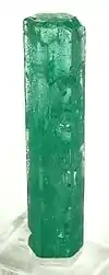
| Emeralds | ||
| Coal | ||
| Salt | ||
| Sources | ||
| Geology |
|  | |||
|---|---|---|---|---|---|
| History |
| ||||
| Main mining areas |
| ||||
| Individual mines | |||||
| Individual emeralds (ct) |
| ||||
| Related articles | |||||
| |||||
This article is issued from Wikipedia. The text is licensed under Creative Commons - Attribution - Sharealike. Additional terms may apply for the media files.