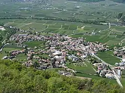
Auer, South Tyrol
Auer (German pronunciation: [ˈaʊ̯ɐ]; Italian: Ora [ˈɔːra]) is a comune (municipality) in South Tyrol in northern Italy, located about 15 kilometres (9 mi) south of the city of Bolzano.
Auer | |
|---|---|
| Marktgemeinde Auer Comune di Ora | |
 | |
Location of Auer 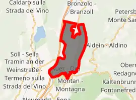
| |
 Auer Location of Auer in Italy 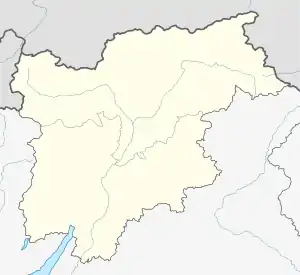 Auer Auer (Trentino-Alto Adige/Südtirol) | |
| Coordinates: 46°21′N 11°18′E | |
| Country | Italy |
| Region | Trentino-Alto Adige/Südtirol |
| Province | South Tyrol (BZ) |
| Government | |
| • Mayor | Martin Feichter |
| Area | |
| • Total | 11.8 km2 (4.6 sq mi) |
| Elevation | 236 m (774 ft) |
| Population (Dec. 2015)[2] | |
| • Total | 3,648 |
| • Density | 310/km2 (800/sq mi) |
| Demonyms | German: Aurer Italian: orensi |
| Time zone | UTC+1 (CET) |
| • Summer (DST) | UTC+2 (CEST) |
| Postal code | 39040 |
| Dialing code | 0471 |
| Website | Official website |
Geography
As of 31 December 2015, it had a population of 3,648 and an area of 11.8 square kilometres (4.6 sq mi).[3]
Auer borders the following municipalities: Aldein, Bronzolo, Montan and Vadena.
History
Coat-of-arms
The shield is party per fess of argent and gules with an azure chief with a rampant lion. It is the emblem of the family Khuen who took possession of the site, from 1397 until 1690, when they were then elevated to the Imperial Counts. On the azure chief two crossed or keys are represented as a remembrance of the insignia of St. Peter, to whom the parish church is dedicated. The emblem was adopted in 1969.[4]
Society
Linguistic distribution
According to the 2011 census, 69.74% of the population speak German, 29.59% Italian and 0.67% Ladin as first language.[5]
|
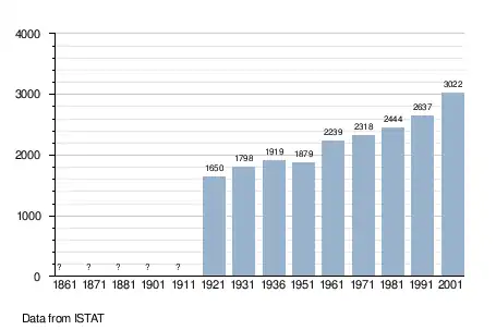
Demographic evolution
References
- "Superficie di Comuni Province e Regioni italiane al 9 ottobre 2011". Istat. Retrieved 16 March 2019.
- "Popolazione Residente al 1° Gennaio 2018". Istat. Retrieved 16 March 2019.
- All demographics and other statistics: Italian statistical institute Istat.
- Heraldry of the World: Auer
- "Volkszählung 2011/Censimento della popolazione 2011". astat info. Provincial Statistics Institute of the Autonomous Province of South Tyrol (38): 6–7. June 2012. Retrieved 2012-06-14.
- Oscar Benvenuto (ed.): "South Tyrol in Figures 2008", Provincial Statistics Institute of the Autonomous Province of South Tyrol, Bozen/Bolzano 2007, p. 16, table 10
External links
![]() Media related to Auer, South Tyrol at Wikimedia Commons
Media related to Auer, South Tyrol at Wikimedia Commons
- (in German and Italian) Homepage of the municipality
| Authority control |
|---|