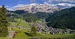
Sëlva
Sëlva (Ladin: [ˈsɜlva] (![]() listen); Italian: Selva di Val Gardena [ˈselva di ˌval ɡarˈdeːna]; German: Wolkenstein in Gröden [ˈwɔlkn̩ʃtaɪ̯n ɪn ˈɡrøːdn̩]) is a comune (municipality) in the Val Gardena in South Tyrol, northern Italy, located about 30 kilometres (19 mi) east of the city of Bolzano. The Ladin place name derives from the Latin word silva ("wood").
listen); Italian: Selva di Val Gardena [ˈselva di ˌval ɡarˈdeːna]; German: Wolkenstein in Gröden [ˈwɔlkn̩ʃtaɪ̯n ɪn ˈɡrøːdn̩]) is a comune (municipality) in the Val Gardena in South Tyrol, northern Italy, located about 30 kilometres (19 mi) east of the city of Bolzano. The Ladin place name derives from the Latin word silva ("wood").
Sëlva | |
|---|---|
| Chemun de Sëlva Comune di Selva di Val Gardena Gemeinde Wolkenstein in Gröden | |
 | |
Location of Sëlva 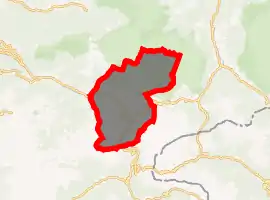
| |
 Sëlva Location of Sëlva in Italy 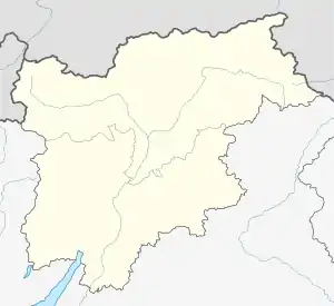 Sëlva Sëlva (Trentino-Alto Adige/Südtirol) | |
| Coordinates: 46°33′N 11°46′E | |
| Country | Italy |
| Region | Trentino-Alto Adige/Südtirol |
| Province | South Tyrol (BZ) |
| Frazioni | Plan |
| Government | |
| • Mayor | Rolando Demetz (SVP) |
| Area | |
| • Total | 53.2 km2 (20.5 sq mi) |
| Elevation | 1,563 m (5,128 ft) |
| Population (Nov. 2010)[2] | |
| • Total | 2,637 |
| • Density | 50/km2 (130/sq mi) |
| Demonym(s) | Ladin: salvans Italian: gardenesi German: Wolkensteiner |
| Time zone | UTC+1 (CET) |
| • Summer (DST) | UTC+2 (CEST) |
| Postal code | 39048 |
| Dialing code | 0471 |
| Website | Official website |
History
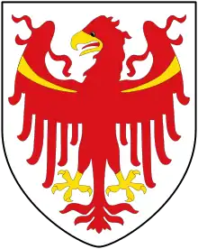
Coat-of-arms
The emblem is quarterly, the first and third corners are per bend and per fess nebuly of argent and gules; the second and third corners are indented of azure and argent on a sable top. The emblem represents the insignia of the Lords of Wolkenstein who built the local castle in 1291. The emblem was adopted in 1968.[3]
Geography
As of 30 December 2010, it had a population of 2,637 and an area of 53.2 square kilometres (20.5 sq mi).[4] Sëlva borders the following municipalities: Badia, Campitello di Fassa, Canazei, Corvara, San Martin de Tor, and Santa Cristina Gherdëina.
It is perhaps best known as one of the starting points of the Sella Ronda ski tour.
Society
Linguistic distribution
According to the 2011 census, 89.74% of the population speak Ladin, 5.15% Italian and 5.11% German as first language.[5]
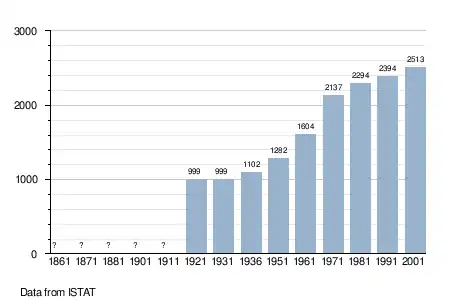
Demographic evolution
Climate
Sëlva is characterized by a typical Alpine climate. Summers are rather short and relatively wet. The average daily temperatures in summer lie between 18 and 21 °C, while at night temperatures usually drop to between 6 and 9 °C. Winters are typically cold, long and relatively dry. The average daily temperatures in winter lie between 0 and 2 °C, while at night temperatures usually drop to between -6 and -9 °C. The wettest month is June with 135 mm, while the driest is February with only 21 mm. This data was measured at the weather station in Plan at an altitude of 1,594 metres between 1991 and 2016.
| Climate data for Sëlva (1991–2016) (location of station: Plan; altitude: 1,594 m) | |||||||||||||
|---|---|---|---|---|---|---|---|---|---|---|---|---|---|
| Month | Jan | Feb | Mar | Apr | May | Jun | Jul | Aug | Sep | Oct | Nov | Dec | Year |
| Record high °C (°F) | 11 (52) |
15 (59) |
17 (63) |
20 (68) |
25 (77) |
27 (81) |
29 (84) |
30 (86) |
26 (79) |
20 (68) |
17 (63) |
11 (52) |
30 (86) |
| Average high °C (°F) | 0.3 (32.5) |
1.8 (35.2) |
5.3 (41.5) |
8.9 (48.0) |
13.7 (56.7) |
17.9 (64.2) |
20.2 (68.4) |
19.3 (66.7) |
14.6 (58.3) |
9.4 (48.9) |
4.0 (39.2) |
0.0 (32.0) |
9.6 (49.3) |
| Daily mean °C (°F) | −3.7 (25.3) |
−3.1 (26.4) |
0.2 (32.4) |
3.8 (38.8) |
8.3 (46.9) |
12.1 (53.8) |
14.2 (57.6) |
13.7 (56.7) |
9.6 (49.3) |
5.2 (41.4) |
0.5 (32.9) |
−3.3 (26.1) |
4.8 (40.6) |
| Average low °C (°F) | −7.6 (18.3) |
−8.1 (17.4) |
−4.8 (23.4) |
−1.3 (29.7) |
2.8 (37.0) |
6.3 (43.3) |
8.2 (46.8) |
8.1 (46.6) |
4.6 (40.3) |
0.9 (33.6) |
−3.0 (26.6) |
−6.5 (20.3) |
−0.1 (31.8) |
| Record low °C (°F) | −19 (−2) |
−21 (−6) |
−21 (−6) |
−16 (3) |
−6 (21) |
−3 (27) |
0 (32) |
−2 (28) |
−6 (21) |
−12 (10) |
−15 (5) |
−21 (−6) |
−21 (−6) |
| Average precipitation mm (inches) | 24.0 (0.94) |
20.8 (0.82) |
36.2 (1.43) |
55.9 (2.20) |
94.4 (3.72) |
135.0 (5.31) |
126.7 (4.99) |
126.7 (4.99) |
85.1 (3.35) |
92.1 (3.63) |
77.2 (3.04) |
37.5 (1.48) |
911.5 (35.89) |
| Average precipitation days (≥ 1.0 mm) | 4.7 | 4.7 | 5.8 | 8.6 | 12.1 | 14.2 | 12.7 | 12.0 | 9.0 | 8.6 | 8.3 | 5.8 | 106.5 |
| Source: Landeswetterdienst Südtirol[6][7] | |||||||||||||
Gallery
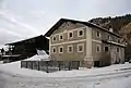 The farmhouse Piciulëi in Sëlva Gherdëina. Southern aspect.
Notable people
- Ferdinando Glück (1901–1987) cross-country skier, competed in the men's 50 kilometre event at the 1928 Winter Olympics
- Hans Nogler (1919–2011 in Sëlva) alpine skier, competed in the 1948 Winter Olympics
- Carlo Senoner (born 1943) retired alpine skier, competed in slalom events at the 1960 and 1968 Winter Olympics
- Adolf Insam (born 1951) ice hockey player, competed in the men's tournament at the 1984 Winter Olympics
- Werner Perathoner (born 1967) former Alpine skier, specialized in downhill and super-G, competed at the 1994 and 1998 Winter Olympics
- Peter Runggaldier (born 1968) former Alpine skier, who specialized in downhill and super-G disciplines, competed at the 1994 and 1998 Winter Olympics, lives in Sëlva
- Karl Unterkircher (1970–2008) mountaineer, opened new mountain routes.
References
- "Superficie di Comuni Province e Regioni italiane al 9 ottobre 2011". Istat. Retrieved 16 March 2019.
- "Popolazione Residente al 1° Gennaio 2018". Istat. Retrieved 16 March 2019.
- Heraldry of the World: Sëlva
- All demographics and other statistics: Italian statistical institute Istat.
- "Volkszählung 2011/Censimento della popolazione 2011". astat info. Provincial Statistics Institute of the Autonomous Province of South Tyrol (38): 6–7. June 2012. Retrieved 2012-06-14.
- "73500MS-TS-SelvaGardena-Wolkenstein.pdf" (PDF). Monatswerte Temperaturen. Landeswetterdienst Südtirol. Retrieved 16 May 2018.
- "73500MS-PS-SelvaGardena-Wolkenstein.pdf" (PDF). Monatswerte Niederschläge. Landeswetterdienst Südtirol. Retrieved 16 May 2018.
External links
![]() Media related to Sëlva at Wikimedia Commons
Media related to Sëlva at Wikimedia Commons
- (in Italian and German) Homepage of the municipality
| Authority control |
|---|