Balclutha, New Zealand
Balclutha (Māori: Iwikatea) is a town in Otago, lying towards the end of the Clutha River, on the east coast of the South Island of New Zealand. It is about halfway between Dunedin and Invercargill on the Main South Line railway, State Highway 1 and the Southern Scenic Route. Balclutha has a population of 4,230 (as of June 2020), and is the largest town in South Otago.
Balclutha
Iwikatea (Māori) | |
|---|---|
Town | |
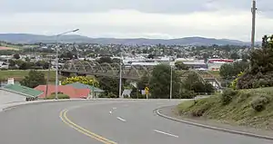 Looking across the Clutha towards the town centre. The distinctive road bridge is visible in the centre of the picture | |
 Balclutha Location of Balclutha within New Zealand | |
| Coordinates: 46°14′S 169°45′E | |
| Country | New Zealand |
| Region | Otago |
| Territorial authority | Clutha District |
| Area | |
| • Total | 7.55 km2 (2.92 sq mi) |
| Population (June 2020)[1] | |
| • Total | 4,230 |
| • Density | 560/km2 (1,500/sq mi) |
| Time zone | UTC+12 (NZST) |
| • Summer (DST) | UTC+13 (NZDT) |
| Postcode(s) | 9230 |
| Area code(s) | 03 |
| Local iwi | Ngāi Tahu |
The Clutha District Council is based in Balclutha.
The major service centre for the fertile farming region around the lower reaches of the Clutha River, it is also the nearest large town to the Catlins, a scenic region of native forest, wildlife, and rugged coastline.
History
Known locally as "Clutha", Balclutha's name – and that of the river on which it stands – reflects the Scottish origin of the town's settlement. The name comes from Scottish Gaelic and would be spelt Baile Cluaidh in that language; this translates into English as "Town on the Clyde".
James McNeil from Bonn Hill, Dumbartonshire, Scotland, who is regarded as the town's founding father, arrived in 1853, via Port Chalmers in 1849. His farm was on the site of the present town, where he and the Provincial Government established a ferry service across the Clutha in 1857; as a result the town was initially called Clutha Ferry.
The Māori name for the area is Iwikatea, literally "Bleached bones" (a local Māori tribal battle in 1750 left the decomposing bodies of the defeated, their bones whitened in the sun).
Demographics
The Balclutha urban area had a usual resident population of 4,110 at the 2018 New Zealand census, an increase of 123 people (3.1%) since the 2013 census, and a decrease of 24 people (0.6%) since the 2006 census. There were 2,010 males and 2,100 females, giving a sex ratio of 0.96 males per female. Of the total population, 675 people (16.0%) were aged up to 15 years, 741 (18.0%) were 15 to 29, 1,734 (42.2%) were 30 to 64, and 957 (23.3%) were 65 or older.[2]
In terms of ethnicity, 86.6% were European/Pākehā, 11.5% were Māori, 3.9% were Pacific peoples, 5.0% were Asian, and 1.3% were other ethnicities (totals add to more than 100% since people could identify with multiple ethnicities).[2]
Landmarks
The Clutha River flows through the town. It is the largest river in New Zealand by volume of water, and the country's second longest after the Waikato. It provides the town with various recreational facilities, including fishing (brown trout), water skiing and power boating.
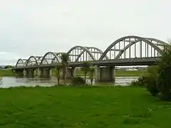
The most prominent structure in the town is the concrete Balclutha Road Bridge across the river, which was built in 1935. The original 1868 wooden bridge was washed away on 14 October 1878. Rebuilt in 1881, it was later considered unsuitable for motor vehicles.
The South Island Main Trunk Railway crosses the river some 800 metres downstream, near the junction where the Clutha River divides into the southern branch, known as the Koau (pied shag), and the northern the Matau (derived from Mata Au, the Maori name for the Clutha).
Most of Balclutha township lies on 'the flat' land which lies within a wide loop in the river to the south of the road bridge, but North Balclutha is on the hill to the north of the bridge and Rosebank on the hill to the south.
There are several natural features in and near Balclutha. Nearby at Benhar / Kaitangata is Lake Tuakitoto, and Matai Falls, a natural waterfall and scenic feature is in the Catlins.[3] The yellow-eyed penguin comes ashore for breeding in the Balclutha area at the edge of the Catlins, and The Nuggets are located at nearby Kaka Point.
Education
Primary schools
Balclutha School is a co-educational state primary school for Year 1 to 8 students,[4] with a roll of 156 as of March 2020.[5]
Rosebank School is a co-educational state primary school for Year 1 to 8 students,[6][7] with a roll of 256.[8]
St Joseph's School is a co-educational state primary school for Year 1 to 8 students,[9] with a roll of 55.[10]
Secondary schools
South Otago High School is a co-educational state secondary school for Year 9 to 13 students,[11][12] with a roll of 456.[13]
Tertiary education
There is one tertiary education facility, Telford, a campus of the Southern Institute of Technology.[14]
Notable people
- Ronald Algie, politician, educated in Balclutha
- John Barr, poet
- Aubrey Begg, politician
- Tony Brown, All Black rugby union player
- Morgan Endicott-Davies, judoka
- Tony Ensor, rugby union player international sevens player
- Matt Faddes, rugby union player and international sevens player
- Phillipa Finch, netball player
- Aaron Gale, international cricketer
- Paul Grant, rugby union player and international rugby sevens player
- Hone Kouka, playwright
- Robbie Johnston, Olympic long-distance runner
- Ian Murray Mackerras, zoologist
- Clive Matthewson, politician
- Jan Mortimer, international draughts player
- Rachel Pullar, women's international cricketer
- Barbara Tilden, international hockey player
- Sarah Tsukigawa, women's international cricketer
- Rob Webster, virologist
- Debbie White, international netball player
- Charles Willocks, rugby union player and All Black
- Jared Wrennall, band member for Steriogram
Notes
- "Population estimate tables - NZ.Stat". Statistics New Zealand. Retrieved 22 October 2020.
- "Age and sex by ethnic group (grouped total response), for census usually resident population counts, 2006, 2013, and 2018 Censuses (urban rural areas)". nzdotstat.stats.govt.nz. Retrieved 13 September 2020.
- Bette Flagler. 2005
- "Balclutha School Ministry of Education School Profile". educationcounts.govt.nz. Ministry of Education.
- "Balclutha School Education Review Office Report". ero.govt.nz. Education Review Office.
- "Rosebank School Official School Website". rosebankschool.co.nz.
- "Rosebank School Ministry of Education School Profile". educationcounts.govt.nz. Ministry of Education.
- "Rosebank School Education Review Office Report". ero.govt.nz. Education Review Office.
- "St Joseph's School Ministry of Education School Profile". educationcounts.govt.nz. Ministry of Education.
- "St Joseph's School Education Review Office Report". ero.govt.nz. Education Review Office.
- "South Otago High School Official School Website". sohs.school.nz.
- "South Otago High School Ministry of Education School Profile". educationcounts.govt.nz. Ministry of Education.
- "South Otago High School Education Review Office Report". ero.govt.nz. Education Review Office.
- "Search Results Web result with site links Telford - Southern Institute of Technology". sit.ac.nz. Southern Institute of Technology.
References
External links
![]() Media related to Balclutha at Wikimedia Commons
Media related to Balclutha at Wikimedia Commons