Balidat Ameur
Balidat Ameur (Arabic: ﺑﻠﻴﺪة ﻋﺎﻣﺮ) (sometimes written Blidet Amor) is a town and commune in Ouargla Province, Algeria, located near the provincial capital of Ouargla. According to the 2008 census it has a population of 14,540,[2] up from 12,135 in 1998,[3] and a population growth rate of 1.9%.[2] The commune is made of two areas, the main town of Balidat Ameur, and the village of Goug 7 kilometres (4.3 mi) to the southeast.[1]
Balidat Ameur
ﺑﻠﻴﺪة ﻋﺎﻣﺮ | |
|---|---|
Commune and town | |
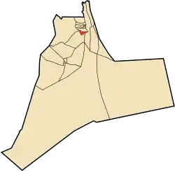 Location of Balidat Ameur commune within Ouargla Province | |
 Balidat Ameur Location of Balidat Ameur within Algeria | |
| Coordinates: 32°57′5″N 5°58′50″E | |
| Country | |
| Province | Ouargla Province |
| District | Témacine District |
| Established[1] | 1984 |
| Area | |
| • Total | 6,589 km2 (2,544 sq mi) |
| Elevation | 92 m (302 ft) |
| Population (2008)[2] | |
| • Total | 14,540 |
| • Density | 2.2/km2 (5.7/sq mi) |
| Time zone | UTC+1 (CET) |
Geography
Balidat Ameur is surrounded by palm plantations that mostly lie in the valleys of the oasis. Apart from in the oasis itself, the nearby land is flat and barren.
Climate
Balidat Ameur has a hot desert climate (Köppen climate classification BWh), with very hot summers and mild winters. Rainfall is light and sporadic, and summers are particularly dry.
Transportation
Balidat Ameur lies a short distance from the N3 national highway between Touggourt to the north and Hassi Messaoud to the south. The town is 140 kilometres (87 mi) from the provincial capital Ouargla,[1] which can be reached by the N56 that turns off the N3 to the south. A local road leads north to the nearby town and district capital of Témacine.
Economy
Balidat Ameur's economy is centered on the farming of date palms, but also features other agricultural crops such as olives, pomegranates, tree grapes, apples and plums. Animals farmed are mainly goats, sheep and camels.[1]
Clay is an important natural resource and contributes towards the buildings and pottery of the region. Other industries include knitting, weaving, and blacksmithing.[1]
Education
The town has eight elementary schools.[1] 5.4% of the population has a tertiary education, and another 16.2% has completed secondary education.[4] The overall literacy rate is 79.0%, and is 87.4% among males and 71.1% among females.[5]
References
- "Official website of the province of Ouargla - Balidat Ameur" (in Arabic). Archived from the original on 24 March 2013. Retrieved 25 February 2013.
- "Population: Ouargla Wilaya" (PDF) (in French). Office National des Statistiques Algérie. Retrieved 24 February 2013.
- "Algeria Communes". Statoids. Retrieved 8 March 2013.
- "Structure relative de la population résidente des ménages ordinaires et collectifs âgée de 6 ans et plus selon le niveau d'instruction et la commune de résidence" (PDF) (in French). Office National des Statistiques Algérie. Retrieved 13 February 2013.
- "Taux d'analphabétisme et taux d'alphabétisation de la population âgée de 15 ans et plus, selon le sexe et la commune de résidence " (PDF) (in French). Office National des Statistiques Algérie. Retrieved 13 February 2013.
- "Décret n° 84-365, fixant la composition, la consistance et les limites territoriale des communes. Wilaya d'El Oued" (PDF) (in French). Journal officiel de la République Algérienne. 19 December 1984. p. 1551. Archived from the original (PDF) on 21 October 2013. Retrieved 2 March 2013.
Places adjacent to Balidat Ameur | ||||||||||
|---|---|---|---|---|---|---|---|---|---|---|
| ||||||||||
Capital: Ouargla | ||
| Ouargla District | .svg.png.webp) | |
| El Borma District | ||
| El Hadjira District | ||
| Hassi Messaoud District | ||
| Mégarine District | ||
| N'Goussa District | ||
| Sidi Khouïled District | ||
| Taïbet District | ||
| Témacine District | ||
| Touggourt District | ||