Bangkalan Regency
Bangkalan Regency is a regency (Indonesian: kabupaten) of East Java province in Indonesia. The seat of its government is Bangkalan. The regency is located on the west side of Madura Island, bordering with Sampang Regency to the east, Java Sea to the north and Madura Strait to the west and the south sides. It covers an area of 1,001.44 km2, and had a population of 906,761 at the 2010 Census (an increase from 805,048 at the previous census in 2000); the 2015 Intermediate Census resulted in a total of 953,659.[2]
Bangkalan Regency
Kabupaten Bangkalan | |
|---|---|
 Seal | |
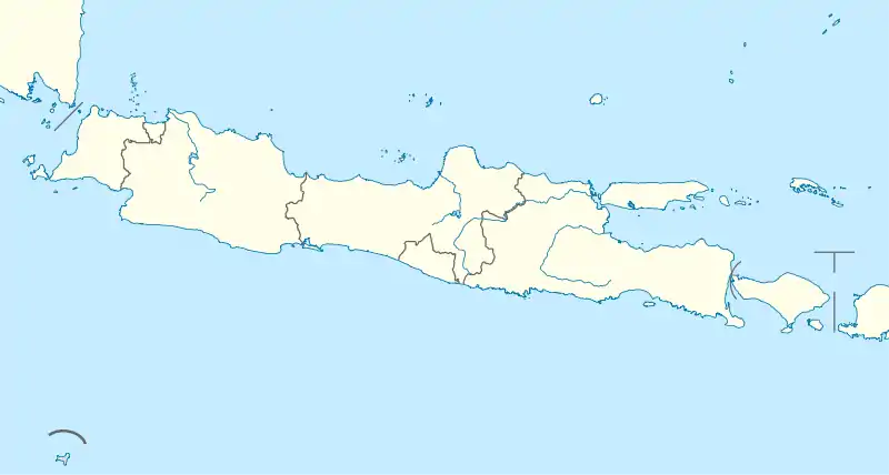
 Location within East Java | |
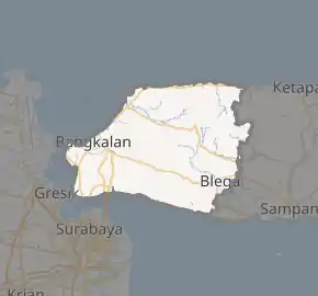
Interactive map outlining Bangkalan Regency | |
| Coordinates: 7°03′S 112°56′E | |
| Country | |
| Province | |
| Capital | Bangkalan |
| Government | |
| • Regent | RK. Muh Makmun Ibnu Fuad |
| • Vice Regent | Mondir A Rofii |
| Area | |
| • Total | 1,001.44 km2 (386.66 sq mi) |
| Population (2015)[1] | |
| • Total | 953,659 |
| • Density | 950/km2 (2,500/sq mi) |
| Time zone | UTC+7 (Indonesia Western Time) |
| Area code | (+62) 31 |
| Website | bangkalankab |

In 2009, the Suramadu Bridge was completed, being the first (toll) bridge ever to connect Java and Madura islands. The Suramadu Bridge is the longest bridge in Indonesia. Previously, Kamal port was the main gateway between Madura island and Java, where ferries serve the port with the Ujung port nearby Surabaya, but nowadays people prefer to travel across the toll bridge than using ferries, so now only a few ferries serve it in day time only.
Bangkalan Regency is included in the Gerbangkertosusila development regions, an extended region of Surabaya industrial areas.
Administrative Districts
Bangkalan Regency consists of eighteen districts (Indonesian: kecamatan), tabulated below with their areas and their populations at the 2010 Census,[3] and the estimated populations in 2013.[4] The table also includes the number of administrative villages (rural desa and urban kelurahan) in each district, and its post code.
| District | Area in Sq.km | Population 2010 Census | Population mid 2013 Estimate | Number of villages | Post code |
|---|---|---|---|---|---|
| Kamal | 41.40 | 45,942 | 47,501 | 109 | 69162 |
| Labang | 35.23 | 33,322 | 34,451 | 13 | 69154 |
| Kwanyar | 47.81 | 41,751 | 43,165 | 16 | 69163 |
| Modung | 78.79 | 43,928 | 45,416 | 17 | 69166 |
| Blega | 92.82 | 52,058 | 52,822 | 19 | 69174 |
| Konang | 81.09 | 45,023 | 46,550 | 13 | 69175 |
| Galis | 120.56 | 72,705 | 75,171 | 21 | 69173 |
| Tanah Merah | 68.56 | 56,798 | 58,722 | 23 | 69172 |
| Tragah | 39.58 | 26,599 | 27,500 | 18 | 69165 |
| Socah | 53.82 | 52,953 | 54,749 | 11 | 69161 |
| Bangkalan (town) | 35.02 | 76,499 | 79,091 | 13 | 69112 -69119 |
| Burneh | 66.10 | 55,840 | 57,733 | 12 | 69121 |
| Arosbaya | 42.46 | 40,203 | 41,566 | 18 | 69151 |
| Geger | 123.31 | 62,755 | 64,883 | 13 | 69152 |
| Kokop | 125.75 | 64,531 | 66,718 | 13 | 69155 |
| Tanjung Bumi | 67.49 | 48,668 | 50,319 | 14 | 69156 |
| Sepulu | 73.25 | 38,826 | 40,141 | 15 | 69154 |
| Klampis | 67.10 | 48,360 | 49,999 | 22 | 69153 |
| Totals | 1,260.14 | 906,761 | 937,497 | 281 |
References
- Badan Pusat Statistik, Jakarta, 2018.
- Badan Pusat Statistik, Jakarta, 2018.
- Biro Pusat Statistik, Jakarta, 2011.
- Badan Pusat Statistik, Jakarta, 2015.