Barobo
Barobo, officially the Municipality of Barobo (Surigaonon: Lungsod nan Barobo; Tagalog: Bayan ng Barobo), is a 3rd class municipality in the province of Surigao del Sur, Philippines. According to the 2015 census, it has a population of 49,730 people. [3]
Barobo | |
|---|---|
| Municipality of Barobo | |
 | |
 Map of Surigao del Sur with Barobo highlighted | |
OpenStreetMap 
| |
.svg.png.webp) Barobo Location within the Philippines | |
| Coordinates: 8°33′N 126°12′E | |
| Country | |
| Region | Caraga (Region XIII) |
| Province | Surigao del Sur |
| District | 2nd District |
| Founded | October 24, 1960 |
| Barangays | 21 (see Barangays) |
| Government | |
| • Type | Sangguniang Bayan |
| • Mayor | Joey S. Pama |
| • Vice Mayor | Allan C. Bernal |
| • Representative | Johnny T. Pimentel |
| • Electorate | 32,013 voters (2019) |
| Area | |
| • Total | 242.50 km2 (93.63 sq mi) |
| Elevation | 48 m (157 ft) |
| Population | |
| • Total | 49,730 |
| • Density | 210/km2 (530/sq mi) |
| • Households | 10,567 |
| Economy | |
| • Income class | 3rd municipal income class |
| • Poverty incidence | 43.76% (2015)[4] |
| • Revenue | ₱127,072,164.91 (2016) |
| Time zone | UTC+8 (PST) |
| ZIP code | 8309 |
| PSGC | |
| IDD : area code | +63 (0)86 |
| Climate type | tropical rainforest climate |
| Native languages | Surigaonon Agusan Cebuano Kamayo Tagalog |
| Website | www |
Geography
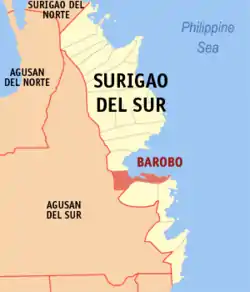
Barobo lies in the central part of the province of Surigao del Sur. It is located between 8'34'00" and 8'25'00" latitude and 125'59"00 and 126'22'4" longitude. It is bounded on the north by Lianga Bay and the municipality of Lianga, on the south by the municipality of Tagbina, on the southeast by the municipality of Hinatuan, on the east by the Pacific Ocean, and on the west by the municipality of San Francisco, Agusan del Sur.
It has total land area of 24,250 hectares (59,900 acres). It is linked by a national road to the provincial capital of Tandag, Surigao del Sur, of 103 kilometers and the gateway to the regional center of the Caraga Region in Butuan City of 107 kilometers.
Tourism
15,000 hectares of its total land is used for the tourism industry with declared tourist destinations namely, Turtle Island, Kabgan Island, Vanishing Islet, Pongpong Resort, Pagbutuanan Cave, Bogac Spring, Bito Lagoon, and Dapdap Beach Resorts. The Barobo River was named as the cleanest urban river in the country by numerous blogging award-giving bodies.
Barangays
Barobo is politically subdivided into 22 barangays.
- Amaga
- Bahi
- Cabacungan
- Cambagang
- Causwagan
- Dapdap
- Dughan
- Gamut
- Javier
- Kinayan
- Mamis
- Poblacion
- Guinhalinan
- Rizal
- San Jose
- San Roque
- San Vicente
- Sua
- Sudlon
- Tambis
- Unidad
- Wakat
Climate
Barobo has a tropical rainforest climate (Af) with heavy to very heavy rainfall year-round.
| Climate data for Barobo | |||||||||||||
|---|---|---|---|---|---|---|---|---|---|---|---|---|---|
| Month | Jan | Feb | Mar | Apr | May | Jun | Jul | Aug | Sep | Oct | Nov | Dec | Year |
| Average high °C (°F) | 29.0 (84.2) |
29.1 (84.4) |
30.1 (86.2) |
31.1 (88.0) |
31.7 (89.1) |
31.6 (88.9) |
31.7 (89.1) |
31.9 (89.4) |
31.9 (89.4) |
31.5 (88.7) |
30.7 (87.3) |
29.7 (85.5) |
30.8 (87.5) |
| Daily mean °C (°F) | 25.3 (77.5) |
25.4 (77.7) |
26.1 (79.0) |
26.8 (80.2) |
27.4 (81.3) |
27.2 (81.0) |
27.2 (81.0) |
27.3 (81.1) |
27.3 (81.1) |
27.1 (80.8) |
26.5 (79.7) |
25.9 (78.6) |
26.6 (79.9) |
| Average low °C (°F) | 21.7 (71.1) |
21.8 (71.2) |
22.1 (71.8) |
22.6 (72.7) |
23.2 (73.8) |
22.9 (73.2) |
22.7 (72.9) |
22.8 (73.0) |
22.7 (72.9) |
22.7 (72.9) |
22.4 (72.3) |
22.2 (72.0) |
22.5 (72.5) |
| Average rainfall mm (inches) | 639 (25.2) |
482 (19.0) |
402 (15.8) |
297 (11.7) |
264 (10.4) |
227 (8.9) |
207 (8.1) |
198 (7.8) |
211 (8.3) |
221 (8.7) |
325 (12.8) |
535 (21.1) |
4,008 (157.8) |
| Source: Climate-Data.org[5] | |||||||||||||
History
Legend has it that the Manobo tribesmen first inhabited the area in the central part of Surigao del Sur. Sometime in the 1930s, five families who were engaged in fishing landed in the up-end of the river, and settled in the area for easy access to the fishing grounds. The area became known for its bountiful fish catch, and therefore more people from neighboring areas also came and settled. The distinctive visual quality of the area was an endemic species of tree known as "barobo" (diplodiscus paniculatus), which was plentiful on the site of the settlement. Subsequently, the place became popularly known as Barobo.
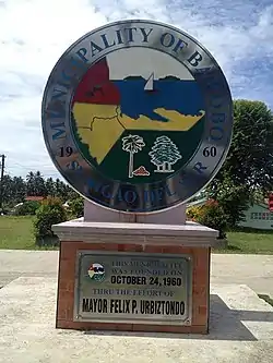
Barobo subsequently became a barrio under the municipality of Lianga. The creation of the province of Surigao del Sur under R.A. No. 2786, series of June 1960, created the municipality of Barobo on October 24, 1960, by virtue of Executive Order No. 407 issued by President Carlos P. Garcia. Thus the Municipality of Barobo was carved out (in a shape resembling that of a cigar pipe) from its mother municipality, Lianga.
Demographics
|
| |||||||||||||||||||||||||||||||||
| Source: Philippine Statistics Authority [3] [6] [7][8] | ||||||||||||||||||||||||||||||||||
Language
A native Barobohanon speaks Kamayo, a minor language spoken in the area of Barobo and also in Bislig City, San Agustin and Marihatag, Surigao del Sur province in the southern Philippines. It has 7,565 speakers (2000, WCD). The dialect known as "Kamayo" varies from one municipality to another — Lingiganons are quite different from other municipalities on the way they speak the Kamayo language.
References
- Municipality of Barobo | (DILG)
- "Province: Surigao del Sur". PSGC Interactive. Quezon City, Philippines: Philippine Statistics Authority. Retrieved 12 November 2016.
- Census of Population (2015). "Caraga". Total Population by Province, City, Municipality and Barangay. PSA. Retrieved 20 June 2016.
- "PSA releases the 2015 Municipal and City Level Poverty Estimates". Quezon City, Philippines. Retrieved 12 October 2019.
- "Climate: Barobo". Climate-Data.org. Retrieved 25 October 2020.
- Census of Population and Housing (2010). "Caraga". Total Population by Province, City, Municipality and Barangay. NSO. Retrieved 29 June 2016.
- Censuses of Population (1903–2007). "Caraga". Table 1. Population Enumerated in Various Censuses by Province/Highly Urbanized City: 1903 to 2007. NSO.
- "Province of Surigao del Sur". Municipality Population Data. Local Water Utilities Administration Research Division. Retrieved 17 December 2016.
External links
- Barobo Profile at PhilAtlas.com
- Philippine Standard Geographic Code
- Philippine Census Information
- Local Governance Performance Management System
Places adjacent to Barobo | ||||||||||
|---|---|---|---|---|---|---|---|---|---|---|
| ||||||||||