Hinatuan
Hinatuan is a second class municipality in the province of Surigao del Sur, Philippines. According to the 2015 census, it has a population of 39,842 people. [3]
Hinatuan | |
|---|---|
| Municipality of Hinatuan | |
 Seal | |
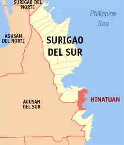 Map of Surigao del Sur with Hinatuan highlighted | |
OpenStreetMap 
| |
.svg.png.webp) Hinatuan Location within the Philippines | |
| Coordinates: 8°22′N 126°20′E | |
| Country | |
| Region | Caraga (Region XIII) |
| Province | Surigao del Sur |
| District | 2nd District |
| Barangays | 24 (see Barangays) |
| Government | |
| • Type | Sangguniang Bayan |
| • Mayor | Shem "Titing" G. Garay |
| • Vice Mayor | Atty. Tito A. Cañedo III |
| • Representative | Johnny T. Pimentel |
| • Electorate | 29,481 voters (2019) |
| Area | |
| • Total | 299.10 km2 (115.48 sq mi) |
| Elevation | 51 m (167 ft) |
| Population | |
| • Total | 39,842 |
| • Density | 130/km2 (350/sq mi) |
| • Households | 8,750 |
| Economy | |
| • Income class | 2nd municipal income class |
| • Poverty incidence | 40.3% (2015)[4] |
| • Revenue | ₱143,891,122.13 (2016) |
| Time zone | UTC+8 (PST) |
| ZIP code | 8310 |
| PSGC | |
| IDD : area code | +63 (0)86 |
| Climate type | tropical rainforest climate |
| Native languages | Surigaonon Agusan Cebuano Tagalog Kamayo |
| Website | hinatuan |
Hinatuan is approximately 44 kilometers (27 miles) north of Bislig, a component city in the same province.
History
Pre-spanish Era
The history of Hinatuan in the annals of historical heritage can be traced back from the time of the Spaniards in this part of Mindanao. The intermingling of tribes such as the Manobos, the Mansakas, Subanons and the Mandayas through assimilation and amalgamation leads to the final unification of a group of people who settled in the old town site known as Da-an Lungsod. Being the first and the earliest settlement, it was later identified as part of the province of Caraga under the administration of the politico - militar of Encomienda Bislig.
The name Hinatuan, originally derived from the word "Hato" and later called "Hatudan" was handed down from generation to generation through oral version. These words have two versions - " Hato " in the native dialect simply connotes a method of preserving fish, the place being abundantly noted for fish. In fact, fishing is the major occupation of the inhabitants. To denote a place , a suffix " an " was added to " Hato " to become " Hatuan "meaning a place where to preserve fish.
Spanish Era
In 1856, the town was transferred to its present site, formerly known as "Hinatudan" now known as Hinatuan as ordered by the higher Spanish authorities. A political government was set up with Raymundo Bandola, the first captain known as defender of the town against the Moro piracy. He was followed by Capitanes Edobigito Lindo, Atanacio de Castro, Tomas Luna, Fernando Nazareno and Teodoro Villaluz. Eugenio Villaluz was accredited the last capitan under the Spanish regime, the first and last captain under the First Philippine Republic, and the first presidential appointee under the American regime. These mentioned capitanes contributed much to the building of the physical set up of the town.
The appointed presidents following Eugenio Villaluz were : Mariano Verano, Pablo Evangelio, Nicomedes Villaluz and Ex-Captain Fernando Nazareno. Domingo Balbuena was the first president - elect and followed by Florencio Villaluz, Antonio Picazales,Victoriano Evangelio, Modesto Raura and Damian Siano. Again, these town executives were responsible for the expansion of the town to a larger area.
Japanese Era
World War II broke out. A few months later, a strong typhoon hit Hinatuan. Heavy damages inflected to both private and public properties especially to buildings, coconut plantations and other potential crops, forest reserves, and machineries and equipment of the Portlamon Lumber Company. Guerilla activities then sprung up to lessen the influence and strength of the Armed Forces of the Empire of Japan and to prepare the people for liberation of the country by the allied forces.
Post War
After the war, Elpedio Chavez was appointed mayor of the town. He was later followed by the first-elect, Mayor Tito Cañedo, Sr., under the Republic of the Philippines. He helped much in the rehabilitation and reconstruction of the town. He was followed by Mayor Joaquin Villaluz , Segundo Cuyno, Sr., Candelario Viola, Sr., Jose Pepino, Sr., the mayor under the Martial Law period, LADP scholar Atty. Candelario J. Viola, Jr., Cristina M. Camba, Dr. Alicia V. Momongan and the incumbent Mayor Shem G. Garay.
Barangays
Hinatuan is politically subdivided into 24 barangays.
Climate
| Climate data for Hinatuan, Surigao del Sur (1981–2010, extremes 1950–2012) | |||||||||||||
|---|---|---|---|---|---|---|---|---|---|---|---|---|---|
| Month | Jan | Feb | Mar | Apr | May | Jun | Jul | Aug | Sep | Oct | Nov | Dec | Year |
| Record high °C (°F) | 34.4 (93.9) |
33.3 (91.9) |
33.5 (92.3) |
36.1 (97.0) |
36.0 (96.8) |
36.2 (97.2) |
36.0 (96.8) |
37.0 (98.6) |
36.6 (97.9) |
36.0 (96.8) |
36.0 (96.8) |
34.7 (94.5) |
37.0 (98.6) |
| Average high °C (°F) | 29.7 (85.5) |
30.1 (86.2) |
30.8 (87.4) |
31.9 (89.4) |
32.5 (90.5) |
32.5 (90.5) |
32.6 (90.7) |
33.0 (91.4) |
32.9 (91.2) |
32.5 (90.5) |
31.5 (88.7) |
30.5 (86.9) |
31.7 (89.1) |
| Daily mean °C (°F) | 26.4 (79.5) |
26.5 (79.7) |
27.0 (80.6) |
27.8 (82.0) |
28.4 (83.1) |
28.2 (82.8) |
28.2 (82.8) |
28.4 (83.1) |
28.2 (82.8) |
28.1 (82.6) |
27.5 (81.5) |
26.9 (80.4) |
27.6 (81.7) |
| Average low °C (°F) | 23.0 (73.4) |
23.0 (73.4) |
23.2 (73.8) |
23.7 (74.7) |
24.2 (75.6) |
24.0 (75.2) |
23.8 (74.8) |
23.9 (75.0) |
23.6 (74.5) |
23.6 (74.5) |
23.5 (74.3) |
23.3 (73.9) |
23.6 (74.5) |
| Record low °C (°F) | 17.2 (63.0) |
18.1 (64.6) |
18.2 (64.8) |
18.4 (65.1) |
20.3 (68.5) |
20.2 (68.4) |
19.0 (66.2) |
19.0 (66.2) |
19.1 (66.4) |
19.9 (67.8) |
19.0 (66.2) |
18.8 (65.8) |
17.2 (63.0) |
| Average rainfall mm (inches) | 776.3 (30.56) |
547.6 (21.56) |
448.3 (17.65) |
318.7 (12.55) |
252.9 (9.96) |
258.1 (10.16) |
218.9 (8.62) |
186.7 (7.35) |
206.5 (8.13) |
270.9 (10.67) |
424.9 (16.73) |
555.1 (21.85) |
4,464.9 (175.78) |
| Average rainy days (≥ 0.1 mm) | 25 | 22 | 23 | 19 | 18 | 17 | 16 | 13 | 15 | 17 | 20 | 23 | 228 |
| Average relative humidity (%) | 88 | 87 | 86 | 84 | 84 | 85 | 83 | 82 | 82 | 84 | 86 | 88 | 85 |
| Source: PAGASA[5][6] | |||||||||||||
Demographics
|
| ||||||||||||||||||||||||||||||||||||||||||||||||
| Source: Philippine Statistics Authority [3] [7] [8][9] | |||||||||||||||||||||||||||||||||||||||||||||||||
Attractions
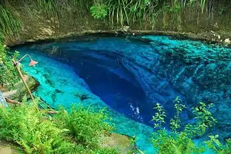
Clear blue waters of the underground river in Barangay Talisay, Hinatuan, popularly called as the "Hinatuan Enchanted River" is a known attraction among tourists both locally and internationally.
References
- Municipality of Hinatuan | (DILG)
- "Province: Surigao del Sur". PSGC Interactive. Quezon City, Philippines: Philippine Statistics Authority. Retrieved 12 November 2016.
- Census of Population (2015). "Caraga". Total Population by Province, City, Municipality and Barangay. PSA. Retrieved 20 June 2016.
- "PSA releases the 2015 Municipal and City Level Poverty Estimates". Quezon City, Philippines. Retrieved 12 October 2019.
- "Hinatuan, Surigao del Sur Climatological Normal Values". Philippine Atmospheric, Geophysical and Astronomical Services Administration. Archived from the original on 14 October 2018. Retrieved 14 October 2018.
- "Hinatuan, Surigao del Sur Climatological Extremes". Philippine Atmospheric, Geophysical and Astronomical Services Administration. Archived from the original on 14 October 2018. Retrieved 14 October 2018.
- Census of Population and Housing (2010). "Caraga". Total Population by Province, City, Municipality and Barangay. NSO. Retrieved 29 June 2016.
- Censuses of Population (1903–2007). "Caraga". Table 1. Population Enumerated in Various Censuses by Province/Highly Urbanized City: 1903 to 2007. NSO.
- "Province of Surigao del Sur". Municipality Population Data. Local Water Utilities Administration Research Division. Retrieved 17 December 2016.
External links
 Media related to Hinatuan, Surigao del Sur at Wikimedia Commons
- Hinatuan Profile at PhilAtlas.com
- Philippine Standard Geographic Code
- Philippine Census Information
- Local Governance Performance Management System
Places adjacent to Hinatuan | |
|---|---|