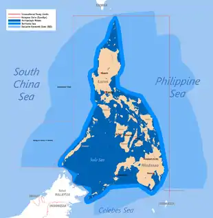
Baselines of the Philippines
The baselines of the Philippines (Filipino: mga batayang-guhit ng Pilipinas) are the set of geodesic lines completely encircling the Philippine archipelago from where the maritime entitlements of the country are measured from. It was first established in 1961[1] by an act of the Congress of the Philippines which was further amended in April 2009 to optimize and conform it to the United Nations Convention on the Law of the Sea, which the Philippines is a signatory to. A total of 101 basepoints providing for 100 baselines were identified under Republic Act No. 9522, which identified Amianan Island as the northernmost, Frances Reef as the southernmost, Pusan Point as its easternmost and the Balabac Great Reef as the westernmost points of the main Philippine archipelago.[2]
Background
The Philippines is an archipelago of 7,100 islands customarily enclosed by the lines demarcated by the Treaty of Paris in 1898 and the Convention Between the United States and Great Britain in 1930, which came to be known in the Philippines as its International Treaty Limits.[3] The government of the Philippines has maintained its position that the waters enclosed by the demarcation lines in the said treaties form part of its territorial waters regardless of its breadth and dimension.[4]
Baselines
The geographic coordinates below are referenced to the World Geodetic System 1984.[5]
| Basepoint number |
Station name | Location | Province | Latitude (N) | Longitude (E) | Distance to next basepoint | ||||
|---|---|---|---|---|---|---|---|---|---|---|
| nmi | km | mi | ||||||||
| 1 | PAB-01 | Amianan Island | Batanes | 21° 6′ 57.73″ | 121° 57′ 27.71″ | 70.03 | 129.70 | 80.59 | ||
| 2 | PAB-02 | Balintang Island | Cagayan | 19° 57′ 38.19″ | 122° 9′ 46.32″ | 99.17 | 183.66 | 114.12 | ||
| 3 | PAB-04 | Iligan Point | Cagayan | 18° 18′ 35.30″ | 122° 20′ 19.07″ | 71.83 | 133.03 | 82.66 | ||
| 4 | PAB-05A | Ditolong Point | Isabela | 17° 7′ 16.30″ | 122° 31′ 28.34″ | 1.05 | 1.94 | 1.21 | ||
| 5 | PAB-05B | Ditolong Point | Isabela | 17° 6′ 14.79″ | 122° 31′ 43.84″ | 0.39 | 0.72 | 0.45 | ||
| 6 | PAB-05 | Ditolong Point | Isabela | 17° 5′ 51.31″ | 122° 31′ 42.66″ | 3.29 | 6.09 | 3.79 | ||
| 7 | PAB-06 | Spires Island | Isabela | 17° 2′ 36.91″ | 122° 31′ 3.28″ | 9.74 | 18.04 | 11.21 | ||
| 8 | PAB-06B | Digollorin Point | Isabela | 16° 53′ 18.03″ | 122° 27′ 56.61″ | 3.51 | 6.50 | 4.04 | ||
| 9 | PAB-06C | Digollorin Rock | Isabela | 16° 49′ 56.11″ | 122° 26′ 50.78″ | 2.40 | 4.44 | 2.76 | ||
| 10 | PAB-07 | Diviuisa Point | Isabela | 16° 47′ 38.86″ | 122° 26′ 4.40″ | 30.94 | 57.30 | 35.61 | ||
| 11 | PAB-08 | Dijohan Point | Aurora | 16° 18′ 44.33″ | 122° 14′ 16.69″ | 116.26 | 215.31 | 133.79 | ||
| 12 | PAB-10A | Tinaga Island | Camarines Norte | 14° 29′ 54.43″ | 122° 57′ 51.15″ | 80.29 | 148.70 | 92.40 | ||
| 13 | PAB-11 | Horodaba Rock | Catanduanes | 14° 6′ 29.91″ | 124° 16′ 59.21″ | 0.54 | 1.00 | 0.62 | ||
| 14 | PAB-12 | Matulin Rock | Catanduanes | 14° 6′ 10.40″ | 124° 17′ 26.28″ | 96.04 | 177.87 | 110.52 | ||
| 15 | PAB-13 | Atalaya Point | Northern Samar | 12° 41′ 6.37″ | 125° 3′ 53.71″ | 6.79 | 12.58 | 7.81 | ||
| 16 | PAB-13A | Bacan Island | Northern Samar | 12° 36′ 18.41″ | 125° 8′ 50.19″ | 5.52 | 10.22 | 6.35 | ||
| 17 | PAB-14 | Finch Rock | Northern Samar | 12° 32′ 33.62″ | 125° 12′ 59.70″ | 0.80 | 1.48 | 0.92 | ||
| 18 | PAB-14A | Cube Rock | Northern Samar | 12° 31′ 57.45″ | 125° 13′ 32.37″ | 4.90 | 9.07 | 5.64 | ||
| 19 | PAB-14D | NW Manjud Point | Northern Samar | 12° 28′ 36.42″ | 125° 17′ 12.32″ | 1.30 | 2.41 | 1.50 | ||
| 20 | PAB-15 | SE Manjud Point | Northern Samar | 12° 27′ 37.51″ | 125° 18′ 5.23″ | 7.69 | 14.24 | 8.85 | ||
| 21 | PAB-16A | E Sora Cay | Northern Samar | 12° 21′ 41.64″ | 125° 23′ 7.41″ | 5.68 | 10.52 | 6.54 | ||
| 22 | PAB-16B | Panablijon | Eastern Samar | 12° 17′ 27.17″ | 125° 27′ 0.12″ | 5.21 | 9.65 | 6.00 | ||
| 23 | PAB-16C | Alugon | Eastern Samar | 12° 13′ 21.95″ | 125° 30′ 19.47″ | 1.94 | 3.59 | 2.23 | ||
| 24 | PAB-16D | N Bunga Point | Eastern Samar | 12° 11′ 48.16″ | 125° 31′ 30.88″ | 0.54 | 1.00 | 0.62 | ||
| 25 | PAB-17A | E Bunga Point | Eastern Samar | 12° 11′ 20.67″ | 125° 31′ 48.29″ | 5.71 | 10.57 | 6.57 | ||
| 26 | PAB-18A | SE Tubabao Island | Eastern Samar | 12° 6′ 7.00″ | 125° 34′ 11.94″ | 83.84 | 155.27 | 96.48 | ||
| 27 | PAB-19C | Suluan Island | Eastern Samar | 10° 45′ 16.70″ | 125° 58′ 8.78″ | 56.28 | 104.23 | 64.77 | ||
| 28 | PAB-19D | N Tuason Point | Surigao del Norte | 9° 49′ 59.58″ | 126° 10′ 6.39″ | 57.44 | 106.38 | 66.10 | ||
| 29 | PAB-20A | Arangasa Island | Surigao del Sur | 8° 53′ 16.62″ | 126° 20′ 48.81″ | 40.69 | 75.36 | 46.83 | ||
| 30 | PAB-21B | Sanco Point | Surigao del Sur | 8° 13′ 11.53″ | 126° 28′ 53.25″ | 30.80 | 57.04 | 35.44 | ||
| 31 | PAB-22 | Bagoso Island | Davao Oriental | 7° 42′ 45.02″ | 126° 34′ 29.03″ | 12.95 | 23.98 | 14.90 | ||
| 32 | PAB-22C | Languyan | Davao Oriental | 7° 29′ 49.47″ | 126° 35′ 59.24″ | 0.54 | 1.00 | 0.62 | ||
| 33 | PAB-23 | Languyan | Davao Oriental | 7° 29′ 16.93″ | 126° 35′ 59.50″ | 0.76 | 1.41 | 0.87 | ||
| 34 | PAB-23B | Languyan | Davao Oriental | 7° 28′ 30.97″ | 126° 35′ 57.30″ | 1.02 | 1.89 | 1.17 | ||
| 35 | PAB-23C | N Baculin Point | Davao Oriental | 7° 27′ 29.42″ | 126° 35′ 51.71″ | 10.12 | 18.74 | 11.65 | ||
| 36 | PAB-24 | Pusan Point | Davao Oriental | 7° 17′ 19.80″ | 126° 36′ 18.16″ | 1.14 | 2.11 | 1.31 | ||
| 37 | PAB-24A | S Pusan Point | Davao Oriental | 7° 16′ 14.43″ | 126° 35′ 57.20″ | 63.28 | 117.19 | 72.82 | ||
| 38 | PAB-25B | Cape San Agustin | Davao Oriental | 6° 17′ 14.73″ | 126° 12′ 14.40″ | 1.28 | 2.37 | 1.47 | ||
| 39 | PAB-25 | Cape San Agustin | Davao Oriental | 6° 16′ 8.35″ | 126° 11′ 35.06″ | 67.65 | 125.29 | 77.85 | ||
| 40 | PAB-26 | SE Sarangani Island | Davao Occidental | 5° 23′ 34.20″ | 125° 28′ 42.11″ | 0.43 | 0.80 | 0.49 | ||
| 41 | PAB-27 | Panguil Bato Point | Davao Occidental | 5° 23′ 21.80″ | 125° 28′ 19.59″ | 3.44 | 6.37 | 3.96 | ||
| 42 | PAB-28 | Tapundo Point | Davao Occidental | 5° 21′ 55.66″ | 125° 25′ 11.21″ | 3.31 | 6.13 | 3.81 | ||
| 43 | PAB-29 | W Calia Point | Davao Occidental | 5° 21′ 58.48″ | 125° 21′ 52.03″ | 0.87 | 1.61 | 1.00 | ||
| 44 | PAB-30 | Manamil Island | Davao Occidental | 5° 22′ 2.91″ | 125° 20′ 59.73″ | 1.79 | 3.32 | 2.06 | ||
| 45 | PAB-31 | Marampog Point | Davao Occidental | 5° 23′ 20.18″ | 125° 19′ 44.29″ | 78.42 | 145.23 | 90.24 | ||
| 46 | PAB-32 | Pola Point | Sultan Kudarat | 6° 9′ 8.44″ | 124° 15′ 42.81″ | 122.88 | 227.57 | 141.41 | ||
| 47 | PAB-33A | Kauluan Island | Basilan | 6° 26′ 47.22″ | 122° 13′ 34.50″ | 29.44 | 54.52 | 33.88 | ||
| 48 | PAB-34A | Tongquil Island | Sulu | 6° 2′ 33.77″ | 121° 56′ 36.20″ | 2.38 | 4.41 | 2.74 | ||
| 49 | PAB-35 | Tongquil Island | Sulu | 6° 1′ 8.15″ | 121° 54′ 41.45″ | 1.72 | 3.19 | 1.98 | ||
| 50 | PAB-35A | Tongquil Island | Sulu | 6° 0′ 17.88″ | 121° 53′ 11.17″ | 85.94 | 159.16 | 98.90 | ||
| 51 | PAB-38A | Kinapusan Island | Tawi-Tawi | 5° 12′ 8.70″ | 120° 41′ 38.14″ | 55.24 | 102.30 | 63.57 | ||
| 52 | PAB-39 | Manuk Manka Island | Tawi-Tawi | 4° 47′ 39.24″ | 119° 51′ 58.08″ | 43.44 | 80.45 | 49.99 | ||
| 53 | PAB-40 | Frances Reef | Tawi-Tawi | 4° 24′ 53.84″ | 119° 14′ 50.71″ | 0.61 | 1.13 | 0.70 | ||
| 54 | PAB-40A | Frances Reef | Tawi-Tawi | 4° 25′ 3.83″ | 119° 14′ 15.15″ | 15.48 | 28.67 | 17.81 | ||
| 55 | PAB-41A | Bajapa Reef | Tawi-Tawi | 4° 36′ 9.01″ | 119° 3′ 22.75″ | 6.88 | 12.74 | 7.92 | ||
| 56 | PAB-42A | Paguan Island | Tawi-Tawi | 4° 42′ 52.07″ | 119° 1′ 44.04″ | 3.40 | 6.30 | 3.91 | ||
| 57 | PAB-43 | Alice Reef | Tawi-Tawi | 4° 45′ 55.25″ | 119° 3′ 15.19″ | 2.28 | 4.22 | 2.62 | ||
| 58 | PAB-44 | Alice Reef | Tawi-Tawi | 4° 47′ 5.36″ | 119° 5′ 12.94″ | 18.60 | 34.45 | 21.40 | ||
| 59 | PAB-45 | Omapoy Rock | Tawi-Tawi | 4° 55′ 10.45″ | 119° 22′ 1.30″ | 23.37 | 43.28 | 26.89 | ||
| 60 | PAB-46 | Bukut Lapis Point | Tawi-Tawi | 5° 2′ 23.73″ | 119° 44′ 18.14″ | 44.20 | 81.86 | 50.86 | ||
| 61 | PAB-47 | Pearl Bank | Sulu | 5° 46′ 35.15″ | 119° 39′ 51.77″ | 75.17 | 139.21 | 86.50 | ||
| 62 | PAB-48 | Baguan Island | Tawi-Tawi | 6° 5′ 58.41″ | 118° 26′ 57.30″ | 8.54 | 15.82 | 9.83 | ||
| 63 | PAB-48A | Taganak Island | Tawi-Tawi | 6° 4′ 14.08″ | 118° 18′ 33.33″ | 13.46 | 24.93 | 15.49 | ||
| 64 | PAB-49 | Great Bakkungaan Island | Tawi-Tawi | 6° 11′ 4.65″ | 118° 6′ 54.15″ | 3.97 | 7.35 | 4.57 | ||
| 65 | PAB-50 | Lihiman Island | Tawi-Tawi | 6° 13′ 39.90″ | 118° 3′ 52.09″ | 5.53 | 10.24 | 6.36 | ||
| 66 | PAB-51 | Sibaung Island | Tawi-Tawi | 6° 17′ 43.99″ | 118° 0′ 5.44″ | 41.60 | 77.04 | 47.87 | ||
| 67 | PAB-52 | Muligi Island | Tawi-Tawi | 6° 52′ 14.53″ | 118° 23′ 40.49″ | 75.06 | 139.01 | 86.38 | ||
| 68 | PAB-53 | South Mangsee Island | Palawan | 7° 30′ 26.05″ | 117° 18′ 33.75″ | 26 | 48.15 | 29.92 | ||
| 69 | PAB-54 | Balabac Island | Palawan | 7° 48′ 30.69″ | 116° 59′ 39.18″ | 6.08 | 11.26 | 7.00 | ||
| 70 | PAB-54A | Balabac Great Reef | Palawan | 7° 51′ 27.17″ | 116° 54′ 17.19″ | 1.18 | 2.19 | 1.36 | ||
| 71 | PAB-54B | Balabac Great Reef | Palawan | 7° 52′ 19.86″ | 116° 53′ 28.73″ | 2.27 | 4.20 | 2.61 | ||
| 72 | PAB-55 | Balabac Great Reef | Palawan | 7° 54′ 36.35″ | 116° 53′ 16.64″ | 7.42 | 13.74 | 8.54 | ||
| 73 | PAB-60 | Ada Reef | Palawan | 8° 2′ 0.26″ | 116° 54′ 10.04″ | 10.85 | 20.09 | 12.49 | ||
| 74 | PAB-61 | Secam Island | Palawan | 8° 11′ 18.36″ | 116° 59′ 51.87″ | 30.88 | 57.19 | 35.54 | ||
| 75 | PAB-62 | Latud Point | Palawan | 8° 37′ 56.37″ | 117° 15′ 51.23″ | 7.91 | 14.65 | 9.10 | ||
| 76 | PAB-63 | SW Tatub Point | Palawan | 8° 44′ 17.40″ | 117° 20′ 39.37″ | 11.89 | 22.02 | 13.68 | ||
| 77 | PAB-63A | W Sicud Point | Palawan | 8° 53′ 32.20″ | 117° 28′ 15.78″ | 13.20 | 24.45 | 15.19 | ||
| 78 | PAB-64 | Tarumpitao Point | Palawan | 9° 2′ 57.47″ | 117° 37′ 38.88″ | 81.12 | 150.23 | 93.35 | ||
| 79 | PAB-64B | Dry Island | Palawan | 9° 59′ 22.54″ | 118° 36′ 53.61″ | 82.76 | 153.27 | 95.24 | ||
| 80 | PAB-65C | Binangcolan Point | Palawan | 11° 13′ 19.82″ | 119° 15′ 17.74″ | 74.65 | 138.25 | 85.91 | ||
| 81 | PAB-67 | Pinnacle Rock | Palawan | 12° 19′ 35.22″ | 119° 50′ 56.00″ | 93.88 | 173.87 | 108.04 | ||
| 82 | PAB-68 | Cabra Island | Occidental Mindoro | 13° 53′ 21.45″ | 120° 1′ 5.86″ | 115.69 | 214.26 | 133.13 | ||
| 83 | PAB-71 | Hermana Mayor Island | Zambales | 15° 48′ 43.61″ | 119° 46′ 56.09″ | 9.30 | 17.22 | 10.70 | ||
| 84 | PAB-72 | Tambobo Point | Pangasinan | 15° 57′ 51.67″ | 119° 44′ 55.32″ | 12.06 | 22.34 | 13.88 | ||
| 85 | PAB-73B | Rena Point | Pangasinan | 16° 9′ 57.90″ | 119° 45′ 15.76″ | 0.25 | 0.46 | 0.29 | ||
| 86 | PAB-73 | Rena Point | Pangasinan | 16° 10′ 12.42″ | 119° 45′ 11.95 | 6.43 | 11.91 | 7.40 | ||
| 87 | PAB-74 | Rocky Ledge | Pangasinan | 16° 16′ 34.46″ | 119° 46′ 19.50″ | 0.65 | 1.20 | 0.75 | ||
| 88 | PAB-74A | Piedra Point | Pangasinan | 16° 17′ 12.70″ | 119° 46′ 28.52″ | 1.30 | 2.41 | 1.50 | ||
| 89 | PAB-75 | Piedra Point | Pangasinan | 16° 18′ 29.49″ | 119° 46′ 44.94″ | 1.04 | 1.93 | 1.20 | ||
| 90 | PAB-75C | Piedra Point | Pangasinan | 16° 19′ 28.20″ | 119° 47′ 7.69″ | 0.63 | 1.17 | 0.72 | ||
| 91 | PAB-75D | Piedra Point | Pangasinan | 16° 20′ 4.38″ | 119° 47′ 20.48″ | 80.60 | 149.27 | 92.75 | ||
| 92 | PAB-76 | Dile Point | Ilocos Sur | 17° 34′ 24.94″ | 120° 20′ 33.36″ | 6.86 | 12.70 | 7.89 | ||
| 93 | PAB-77 | Pinget Island | Ilocos Sur | 17° 41′ 17.56″ | 120° 21′ 2.02″ | 14.15 | 26.21 | 16.28 | ||
| 94 | PAB-78 | Badoc Island | Ilocos Norte | 17° 55′ 4.13″ | 120° 24′ 40.56″ | 35.40 | 65.56 | 40.74 | ||
| 95 | PAB-79 | Cape Bojeador | Ilocos Norte | 18° 29′ 32.42″ | 120° 33′ 42.41″ | 1.77 | 3.28 | 2.04 | ||
| 96 | PAB-79B | Bobon | Ilocos Norte | 18° 30′ 52.88″ | 120° 34′ 55.35″ | 53.23 | 98.58 | 61.26 | ||
| 97 | PAB-80 | Calagangan Point | Cagayan | 19° 10′ 14.78″ | 121° 12′ 52.64″ | 98.07 | 181.63 | 112.86 | ||
| 98 | PAB-82 | Itbayat Island | Batanes | 20° 43′ 15.74″ | 121° 46′ 57.80″ | 25.63 | 47.47 | 29.49 | ||
| 99 | PAB-83 | Amianan Island | Batanes | 21° 7′ 17.47″ | 121° 56′ 43.85″ | 0.08 | 0.15 | 0.09 | ||
| 100 | PAB-84 | Amianan Island | Batanes | 21° 7′ 18.41″ | 121° 56′ 48.79″ | 0.25 | 0.46 | 0.29 | ||
| 101 | PAB-85 | Amianan Island | Batanes | 21° 7′ 12.04″ | 121° 57′ 3.65″ | 0.44 | 0.81 | 0.51 | ||
See also
References
- "Limits in the Seas: No. 142 Philippines: Archipelagic and other Maritime Claims and Boundaries" (PDF). 142. United States Department of State: 1–18. Retrieved November 26, 2015. Cite journal requires
|journal=(help) - "Republic Act No. 9522". Official Gazette. GOVPH. Retrieved November 26, 2015.
- Bautista, Lowell B. "The Philippine Treaty Limits and Territorial Waters Claim in International Law". Retrieved November 26, 2015. Cite journal requires
|journal=(help) - Wolfrum, Rüdiger (1991). Law of the sea at the crossroads. Berlin: Duncker & Humblot. p. 123. ISBN 3-428-07240-5. Retrieved November 26, 2015.
- "Deposit by the Republic of the Philippines of a list of geographical coordinates of points pursuant to article 47, paragraph 9, of the Convention" (PDF). April 21, 2009. Retrieved November 26, 2015. Cite journal requires
|journal=(help)
External links
- Republic Act No. 3046, An Act to Define the Baselines of the Territorial Sea of the Philippines
- Republic Act No. 5446, An Act to Amend Section One of Republic Act Numbered Thirty Hundred and Forty-six, Entitled “an Act to Define the Baselines of the Territorial Sea of the Philippines”
- Republic Act No. 9522, An Act to Amend Certain Provisions of Republic Act No. 3046, as Amended by Republic Act No. 5446, to Define the Archipelagic Baselines of the Philippines, and for Other Purposes
Geography of the Philippines | ||
|---|---|---|
| Geology |  | |
| Landforms |
| |
| Water | ||
| Seas | ||
| Environment |
| |
