Extreme points of the Philippines
This is a list of points in the Philippines that are farther north, south, east, or west than any other location in the country. Also included are extreme points in elevation, extreme distances, and other points of geographic interest.
.svg.png.webp)
Mavulis (Y'Ami)
Frances Reef
Balabac Great Reef
Pag-Asa (disputed)
Pusan Point
Mt. Apo
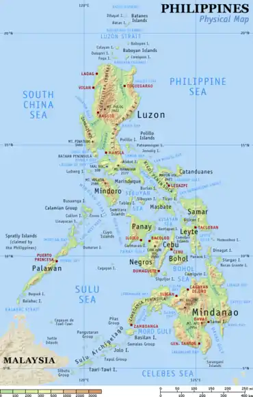
Extreme points of the Philippines.
Republic Act No. 9522 of 2009,[1] defines the archipelagic baselines of the Philippines.
Location points
- Northernmost point: Mavulis (Y'Ami) Island, Itbayat, Batanes 21°7′18.41″N 121°56′48.79″E
- Southernmost point: Frances Reef, Sitangkai, Tawi-Tawi 4°24′53.84″N 119°14′50.71″E/Saluag Island, Sibutu, Tawi-Tawi
- Easternmost point: Pusan Point, Caraga, Davao Oriental 7°17′19.80″N 126°36′18.16″E
- Westernmost point: Balabac Great Reef, Balabac, Palawan 7°54′36.35″N 116°53′16.64″E
- Subject to territorial dispute: Pag-asa Island, Kalayaan, Palawan 11°3′N 114°17′E
Cities
- Northernmost city: Laoag
- Southernmost city: General Santos
- Easternmost city: Bislig
- Westernmost city: Puerto Princesa
Luzon Island
- Northernmost point: Maira-ira, Pagudpud, Ilocos Norte 18°39′4.44″N 120°50′46.68″E
- Southernmost point: Bon-Ot Big, Matnog, Sorsogon 12°31′N 124°02′E
Mindanao Island
- Northernmost point: Punta Bilar, Surigao City
- Southernmost point: Tinaca Point, Jose Abad Santos, Davao Occidental
Altitude
- Highest: Mount Apo, Mindanao 2,954 meters (9,692 ft) 7°0′30″N 125°16′33″E
- Lowest: Galathea Depth, Philippine Trench, 10,540 meters (34,580 ft). It is the third-deepest in the world after the Challenger Deep, Marianas Trench (10,971 meters (35,994 ft)) and the Tonga Trench (10,882 meters (35,702 ft)).
See also
References
- "Republic Act No. 9522". Official Gazette of the Republic of the Philippines. Archived from the original on August 14, 2018. Retrieved May 14, 2019.
This article is issued from Wikipedia. The text is licensed under Creative Commons - Attribution - Sharealike. Additional terms may apply for the media files.
