Bayswater railway station, Perth
Bayswater railway station is located on the Midland Line in Perth, Western Australia. It is operated by Transperth serving the suburb of Bayswater.
Bayswater | |||||||||||||||||||||||||||||||
|---|---|---|---|---|---|---|---|---|---|---|---|---|---|---|---|---|---|---|---|---|---|---|---|---|---|---|---|---|---|---|---|
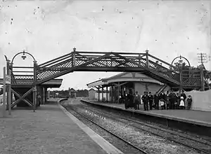
_36.jpg.webp) | |||||||||||||||||||||||||||||||
| Location | King William Street, Coode Street, Railway Parade, Whatley Crescent Bayswater Western Australia Australia | ||||||||||||||||||||||||||||||
| Coordinates | 31.9184°S 115.9125°E | ||||||||||||||||||||||||||||||
| Owned by | Transperth | ||||||||||||||||||||||||||||||
| Operated by | Transperth | ||||||||||||||||||||||||||||||
| Line(s) | Midland line | ||||||||||||||||||||||||||||||
| Distance | 6.7 km (4.2 mi) from Perth | ||||||||||||||||||||||||||||||
| Platforms | 2 (1 island) | ||||||||||||||||||||||||||||||
| Tracks | 2 | ||||||||||||||||||||||||||||||
| Bus routes | 3 | ||||||||||||||||||||||||||||||
| Connections | Bus transfer at Coode Street | ||||||||||||||||||||||||||||||
| Construction | |||||||||||||||||||||||||||||||
| Structure type | Ground | ||||||||||||||||||||||||||||||
| Parking | Yes | ||||||||||||||||||||||||||||||
| Bicycle facilities | Yes | ||||||||||||||||||||||||||||||
| Disabled access | Yes | ||||||||||||||||||||||||||||||
| Other information | |||||||||||||||||||||||||||||||
| Status | Unstaffed | ||||||||||||||||||||||||||||||
| Station code | MBR | ||||||||||||||||||||||||||||||
| Fare zone | 1 | ||||||||||||||||||||||||||||||
| History | |||||||||||||||||||||||||||||||
| Opened | 1896 | ||||||||||||||||||||||||||||||
| Electrified | Yes | ||||||||||||||||||||||||||||||
| Services | |||||||||||||||||||||||||||||||
| |||||||||||||||||||||||||||||||
History
Bayswater station opened in 1896. From 1897 until 1956 it was the junction station for the Belmont spur line to the nearby Ascot Racecourse.[1][2]
Originally built as two side platforms, the station was later rebuilt as a single island platform. In 2021, Bayswater is scheduled to become a junction station again, when the Forrestfield–Airport Link opens to the east;[3][4]
The King William Street bridge (dubbed "The Bayswater Bridge" by locals), which runs under the station, has gained notoriety throughout the years for its low 3.8 meter clearance. As of 27 December 2020, 54 vehicles have been involved in incidents related to the bridge.[5]
2020 changes
In 2020, the bridge will be replaced as part of the Forrestfield–Airport link and the revitalisation of Bayswater Station[6] and again in 2023–2024 when the Morley–Ellenbrook railway line opens northward.[7]
Platforms
| Stop | Platform | Line | Stopping pattern | Destination | Notes |
|---|---|---|---|---|---|
| 99461 | 1 | Midland | All stations, A, B, P | Perth | |
| 99462 | 2 | Midland | All stations, A, B, P | Midland |
Bus routes
The station acts as a transfer station for a number of bus routes, with stops located adjacent to the station on Coode Street.[8][9][10]
| Stop | Route | Destination / description | Notes |
|---|---|---|---|
| [11627] Coode Street (south-east bound) | 48 | to Elizabeth Quay Bus Station via Guildford Road[9] | |
| 998 | CircleRoute to Fremantle station via Ascot & Belmont Forum[10] | Limited stops[10] | |
| [11350] Coode Street (north-west bound) | 48 | to Morley bus station via Langley Road[9] | |
| 999 | CircleRoute to Fremantle station via Morley & Dianella[11] | Limited stops[11] | |
| [22065] Whatley Crescent (south-west bound) | 905 | Rail replacement service to Perth station | |
| [16547] Whatley Crescent (north-east bound) | 905 | Rail replacement service to Midland station | |
| 684 | to Crown Perth, Burswood |
References
- Quinlan, Howard; Newland, John R; Australian Railway Historical Society. New South Wales Division (2000), Australian railway routes 1854 to 2000, Australian Railway Historical Society – New South Wales Division, ISBN 978-0-909650-49-0 page 66 WN 36
- History of stations on the Midland line Right Track
- Perth rail link approved Railway Gazette International 13 August 2014
- Forrestfield-Airport Link Public Transport Authority August 2014
- "How Many Days Since The Bayswater Bridge Has Been Hit?". Retrieved 20 May 2020.
- "Contract awarded for Bayswater train station upgrade, including new 'Bayswater Bridge'". PerthNow. 20 May 2020. Retrieved 20 May 2020.
- "WA fast-tracks $140 million of transport construction projects". Infrastructure Magazine. 5 May 2020. Retrieved 24 May 2020.
- "Transperth Network Sheet 3" (PDF). Transperth. Retrieved 2 February 2015.
- "Route 48". Bus Timetable 103 (PDF). Transperth. n.d. [effective from 25 August 2019].
- "Route 998". CircleRoute Timetable 200 (PDF). Transperth. n.d. [effective from 21 July 2019].
- "Route 999". CircleRoute Timetable 200 (PDF). Transperth. n.d. [effective from 21 July 2019].
| Central area | |
|---|---|
| Northern area | |
| Eastern area | |
| Western area | |
| South eastern area | |
| Southern area | |
| Former stations | |
| Bus routes | |
Bus stations marked with | |