Bayswater, Western Australia
Bayswater is a suburb 6 kilometres (3.7 mi) north-east of the central business district of Perth, the capital of Western Australia. It is just north of the Swan River, within the City of Bayswater local government area. It is predominantly a low density residential suburb consisting of single-family detached homes. However, there are several clusters of commercial buildings, most notably in the suburb's town centre around the intersection of Whatley Crescent and King William Street, and a light industrial area in the suburb's east.
| Bayswater Perth, Western Australia | |||||||||||||||
|---|---|---|---|---|---|---|---|---|---|---|---|---|---|---|---|
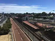
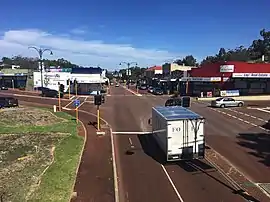 View of King William Street south from the Bayswater Bridge | |||||||||||||||
 Bayswater Location in metropolitan Perth | |||||||||||||||
| Coordinates | 31.911°S 115.919°E | ||||||||||||||
| Population | 14,432 (2016 census)[1] | ||||||||||||||
| • Density | 1,468.2/km2 (3,802.5/sq mi) | ||||||||||||||
| Established | 1885 | ||||||||||||||
| Postcode(s) | 6053 | ||||||||||||||
| Area | 9.83 km2 (3.8 sq mi)[2] | ||||||||||||||
| Location | 6 km (4 mi) from Perth | ||||||||||||||
| LGA(s) | City of Bayswater | ||||||||||||||
| State electorate(s) | Maylands, Bassendean | ||||||||||||||
| Federal Division(s) | Perth | ||||||||||||||
| |||||||||||||||
Prior to European settlement, the area was inhabited by the Mooro group of the Whadjuk Noongar people. In 1830, the year after the European settlement of the Swan River Colony, land was divided up along the river between the colonists, who moved in soon after. Most either died or left in the months afterwards, leaving the area undeveloped for most of the 20th century. In 1881, the Fremantle–Guildford railway line was built, triggering the founding of the Bayswater Estate, the first development in the area, and in 1897, the Bayswater Road Board was founded, giving Bayswater its own local government. At first, development consisted of nurseries, market gardens and dairies, but as time went on, Bayswater became more and more suburban. Today, Bayswater is fully suburbanised, with subdivision of older lots being commonplace, and plans for apartments around Bayswater and Meltham railway stations being a contentious issue.
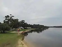
Bayswater's Swan River foreshore is lined with parks and wetlands, including the Baigup Wetlands, Eric Singleton Bird Sanctuary and Riverside Gardens. There are other parks throughout the suburb, including Bert Wright Park, Halliday Park (which includes a war memorial), Hillcrest Reserve and Houghton Park. Major roads through the suburb include Guildford Road, which connects to the Perth CBD, and Tonkin Highway.
History
Early history
Prior to European settlement, the area was inhabited by the Mooro group of the Whadjuk Noongar people. The Mooro group were led by Yellagonga, and inhabited the area north of the Swan River, as far east as Ellen Brook and north to Moore River. The Swan River provided fresh water and food, as well as being a place for trade. A camping ground, at least 4,500 years old existed just north of the present-day junction of Tonkin Highway and Guildford Road. Another camping ground likely existed in the area now known as the Baigup Wetlands.[3][4]
When Europeans founded the Swan River Colony in 1829, they did no recognise the indigenous ownership of the land. Land along the Swan River was surveyed by John Septimus Roe, the colony's Surveyor General. The survey resulted in the land being divided into long, narrow rectangular strips extending from the river. As the river was the only method of transportation in the early years of the colony, each piece of land had to have river frontage. The long, narrow strips were called "ribbon grants". In 1830, the colonists travelled up the river to the land allotted to them. Most of these colonists either died or left the area soon after though, as the land was waterlogged and of poor quality.[4]
An example of these early colonists is the family of John and Anne Whatley, their children Joan and Mary, and their servants, the Embletons, who lived in "Swan Location T", the area between the present day Tonkin Highway and Slade Street. They arrived in Fremantle in October 1829, and settled on the land in February 1830, as they had to wait for the land to be surveyed. Anne Whatley wrote in her diary about the difficulties of establishing a farm on their property. In September 1830, John Whatley died, and Anne Whatley and her children subsequently left the Swan River Colony forever. Similar stories like this played out with the other landowners in Bayswater.[4][5]
Between 1830 and 1880, only two houses are known to have been built in the Bayswater area: one owned by Frederick Sherwood, and another by John Scrivener. Neither house stand today. The oldest remaining evidence of European settlement in the area is an olive tree on Slade Street, planted in the 1840s and used as a place for religious services. That olive tree is now represented on the logo of the City of Bayswater.[6] The only other obvious sign of settlement in that era was a track constructed in the early 1830s that goes from Perth to Guildford. That track became what is now known as Guildford Road.[4]
Development
In 1881, the Fremantle–Guildford railway line railway line was built, which passed through Bayswater and triggered significant development. The original ribbon grants began to be subdivided. The first section to be developed was called Bayswater Estate, which was the land between Drake and Lawrence Streets. It was subdivided into 2-hectare (5-acre) lots in for small farming in 1885. A road was constructed down the middle of it, called Coode Street north of the railway line and King William Street south of the railway line. At this time, market gardens were also popping up in the swampy area near the river. Farms and dairies were built along Coode Street. In c. 1886, a branch railway line was built to the river bank near where the Eric Singleton Bird Sanctuary currently is. The intention of the branch was for it to be the start of a railway to Busselton, however this did not eventuate. Instead, a footbridge was built across the river a year later, linking Bayswater to Ascot Racecourse, and a station called Whatley siding was built on the line. In 1896, Bayswater railway station was built, and in 1897, the spur line was extended to Ascot Racecourse, becoming the Belmont spur line. Bayswater's first industrial buildings were built near the spur line.[4]
In the 1890s, the original 2-hectare (5-acre) subdivisions in Bayswater Estate began to be re-subdivided, resulting in closer housing. At this time, the population of Bayswater was approximately 400. Up until 1897, Bayswater was split between the Perth and Swan road boards, but locals did not feel like they were adequately represented by either. In 1897, the Bayswater Road Board was formed, and a wooden ratepayer's hall was built on Guildford Road.[4]
When gold was discovered in the colony, in the present day Goldfields-Esperance region, many people from eastern Australia and overseas came to the Swan River Colony, and eventually settled in Bayswater. Yet still, Bayswater was semi-rural, with people buying land for garden and farming homes.[4]
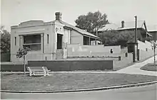
The opening of the Midland Railway Workshops down the railway line in 1904 brought workers from the eastern states and overseas, Britain in particular, fuelled much growth, and more permanent buildings were constructed. Many still stand, such as Ellis House, Halliday House, and some commercial buildings along King William Street in the town centre, which are now heritage listed. Bayswater School, which was founded in 1894, was expanded in 1900, 1906, 1910 and 1914 to service the rapidly expanding population. In 1910, the Bayswater Bridge was constructed, removing the dangerous level crossing of the railway line.[4][7]
In 1933, Bayswater introduced a town planning scheme, re-enforcing the developing industrial area in the east, and setting aside land for future residential areas. This was one of the first town planning schemes in Western Australia, and it preceded the Stephenson–Hepburn Report by 22 years. In 1934, a railway station between Bayswater and Maylands was first suggested. In 1935, the first Garratt Road Bridge was built across the Swan River, providing a link from Bayswater to Ascot. In March 1939, the townsite of Meltham Heights was approved, but development of that area was delayed by World War II.[4][8][9]
During World War II, Bayswater became a place for signalling operations, and many homes were taken over for that. After World War II, development finally happened in Meltham Heights, although the name ended up not being used as a suburb. Meltham railway station was built in 1948,[8][9] and the Belmont spur line closed down in 1956 after the bridge crossing the Swan River was damaged by fire. Due to large growth, there was demand for another school in the area, so buildings from East Fremantle were transported to a new site at Hillcrest, which opened in 1962.[4]
In 1971–72, the second Garratt Road Bridge was built. Both bridges are now heritage listed. In the early 1980s, Tonkin Highway was built between Railway Parade and Morley Drive, dividing the suburb and changing the character of the area. Beechboro Road and Irvine / Clune Street were split in two by the highway. It had been planned since the 1960s, and had affected the development of the area.[4][10][11] In 1988, Tonkin Highway was extended south of Railway Parade, linking it to the other side of the river.
21st century
.JPG.webp)
Development in the Bayswater town centre and around Meltham railway station was a contentious issue in the 2010s and 2020s. The City of Bayswater started work on a structure plan for the Bayswater town centre in November 2015.[12] The structure plan would plan for building heights, land uses and connections for cars, pedestrians and cyclists.[13] A draft for the structure plan was released in July 2017,[14] and public comments on it were invited in August 2017.[15] In June 2019, the process started for creating a "redevelopment area" around the town centre.[16] This would take development planning control away from the local government, and give it to the state government's DevelopmentWA.[17] The process was completed in March 2020.[18] In February 2020, City of Bayswater councillors voted to heritage protect the entire town centre. This resulted in backlash from some residents and the community group Future Bayswater, who say that it may hamper development and protect buildings with little-to-no heritage value. However other residents and the community group Bayswater Deserves Better praised the move for heritage protection.[19] The structure plan was finalised in June 2020.[20][21]
In 2019 and 2020, the City of Bayswater proposed to turn part of eastern Bayswater into a new suburb called Meltham. The new suburb would have centred on Meltham railway station, and would have has an area of 107 ha (260 acres). Its purpose was to give the area around the station its own identity. Responses from the residents indicated that 54% were opposed to the renaming due to various reasons, including criticism of the name, worries that property values would decrease and association of Meltham with anti social behaviour. City of Bayswater councillors decided in May 2020 to not proceed with the new suburb.[8][22][23]
Name
The suburb Bayswater was named after a subdivision of a 1,000-acre (400 ha) land parcel centred on what is now King William Street / Coode Street. The estate was named "Bayswater" when the 5-acre (2.0 ha) lots were first advertised for sale by Feinberg and Rogers auctioneers on 4 July 1885.[24] That property is presumed to be named after the London suburb of Bayswater.[25]
Geography
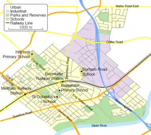
Bayswater is located 6 kilometres (3.7 mi) north-east of the central business district of Perth, the capital of Western Australia, 15 km (9.3 mi) east of the Indian Ocean, and covers an area of 9.83 square kilometres (3.80 sq mi). The elevation ranges from 2 m (6 ft 7 in) on the banks of the Swan River to 45 m (148 ft) at Hillcrest Primary School. The suburb is bounded on the south by the Swan River, with Ascot on the other side of the river, bounded to the west by Maylands, bounded to the north by Bedford, Embelton and Morley, and bounded to the east by Bassendean and Ashfield, which are in the Town of Bassendean. Bayswater also shares corners with Inglewood and Eden Hill.
Bayswater consists predominantly of low density single-family detached homes, zoned as "urban" in the Metropolitan Region Scheme. There is an industrial area in the eastern parts of the suburb, and a small town centre around King William Street and Whatley Crescent.[26] The suburb is divided by Tonkin Highway and the Midland railway line.
The streets throughout the suburb mostly follow a grid pattern. The roads that are perpendicular to the Swan River are remnants from the rectangular ribbon grants which extended from the river, and some of the roads which are roughly parallel to the river are remnants of the later subdivision of Bayswater into 5 acre lots. Streets named after early residents and landowners of Bayswater include Whatley Crescent, which was named after Anne and John Whatley, Hamilton Street, which was named after John Hamilton, Copley Street, which was named after Benjamin Copley, and Drake Street, which was named after Henry Drake. Another origin of many street names in Bayswater is towns and streets in England, such as Almondbury Street, Arundel Street, Clavering Street or Shaftesbury Avenue.[4]
Bayswater lies on the Bassendean Dunes, which formed 800,000 to 125,000 years ago during the middle Pleistocene. The dunes form low-lying hills made of heavily leached white to grey sands, which are poor at retaining nutrients. Groundwater is generally about 10 m (33 ft) below the surface. The Bassendean Dunes are a part of the greater Swan Coastal Plain.[4][27][28]
Bayswater Brook was a natural brook that ran through Bayswater and nearby suburbs, linking various swamps and creeks in the area. In the 1920s, due to development, it was modified into a network of drainage channels, with some covered sections and some open sections. The brook discharges into the Eric Singleton Bird Sanctuary, which discharges into the Swan River.[29][30][31][32] The Eric Singleton Bird Sanctuary is an artificial wetland, created after the surrounding area was used as a landfill between 1972 and 1981. The wetland had significant environmental problems until it was rehabilitated in 2015.[33][34] Nearby is Gobba Lake, an artificial deepwater lake named after Gino Gobba, a former City of Bayswater councillor. It was made for a clay pit used by Walkenden's Brickworks. Gobba Lake also underwent rehabilitation to make it more attractive to flora and fauna, and make it better for recreational use by humans.[35]
Erosion of the Swan River foreshore due to boat traffic is a problem in Bayswater. At least 5m of erosion has occurred between 1995 and 2020. The City of Bayswater is currently funding works to prevent and fix erosion that has occurred.[36]
Demographics
Bayswater's population at the 2016 census was 14,432.[1] This is an increase on the 13,525 recorded at the 2011 census,[37] 12,152 recorded at the 2006 census,[38] and the 11,303 recorded at the 2001 census.[39] 49.1% of residents are male, and 50.9% are female. The median age is 38, which is above the Western Australian average of 36, and 44.3% of residents over the age of 15 are married, which is below the state average of 48.8%.[1]
The median weekly household income was $1,705, which is higher than the state and the country, which are at $1,595 and $1,438 respectively.[1] Major industries that residents worked in were school education (4.7%), cafés, restaurants and takeaway food services (4.5%), architectural, engineering and technical services (4.0%), hospitals (3.7%), and state government administration (3.7%). 4% of residents are unemployed, which is below the state average of 4.7%.[37]
The population of Bayswater is predominantly Australian born, with 62.5% of residents were born in Australia, which is around the state average of 62.9%. The next-most-common birthplace was England (7.0%), New Zealand (2.9%), India (2.9%), Italy (1.6%), and Vietnam (1.2%).[37]
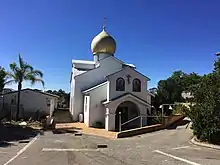
The most popular religious affiliations were no religion, with 28.6%, Roman Catholicism (27.4%), Anglicanism (14.9%), Uniting Church (2.7%), and Buddhism (2.4%). Churches in Bayswater include Saint Columba's Catholic Church, Apostolic Church, and a Russian Orthodox Church, which happens to be the only one in Perth.[37][40]
Parks and Amenities
.JPG.webp)
.JPG.webp)
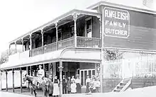
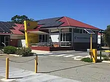
Bayswater has a small town centre around the intersection of Whatley Crescent and King William Street. Amenities there include the Bayswater Library and Community Centre, a Bendigo Bank community branch, an Australia Post post office, a WA Police station, a hotel and various small businesses. Businesses along Guildford Road include Muzz Buzz, Red Rooster, a Mazda dealer and a car rental. Businesses and services in the industrial area in Bayswater's east include a Bunnings Warehouse and the Baywaste Transfer Station, run by Cleanaway. The nearest shopping centre to Bayswater is the Galleria, in Morley. Other shopping precincts are in Bassendean, Inglewood and Maylands, which all have major supermarkets.
Lining the Swan River in Bayswater is various parks and reserves. Starting from the west, the 16.4 ha (41-acre) Baigup Wetlands are one of the last remaining areas of natural bushland along the Swan River's estuary, and an important habitat for birds.[40][41] A.P. Hinds Reserve is home to ANA Rowing Club,[42] Bayswater Paddlesports Club and Bayswater Sea Scouts. Riverside Gardens is a popular park for dogs and picnics, and has a playground, boat ramp, café and a large open grassed area.[43][44] Annual events held here include the Autumn River Festival and the finish line of the Avon Descent, both of which involve food stalls and entertainment.[45][46] Nearby is the heritage listed Ellis House, which was restored by the City of Bayswater, and is now a community art centre.[47][48] Next to Riverside Gardens is the Eric Singleton Bird Sanctuary, an artificial wetland and bird habitat,[49] and on the other side of Tonkin Highway is Claughton Reserve, a large park with a boat ramp and playground.[50]
On the corner of Whatley Crescent and Garratt Road is the Frank Drago Reserve, which is home to the Bayswater City Soccer Club, Bayswater Bowls and Recreation Club, Bayswater Croquet Club and Bayswater Tennis Club.[51] In the suburb's town centre, there is Bert Wright Park, which hosts the Bayswater Growers' Market every Saturday,[52][53] and Halliday Park, which is home to the Bayswater Lacrosse Club and AIM Over 50 Archery Club,[54] and has a war memorial which hosts an annual Anzac Day dawn service.[55] Between Coode Street and Drake Street, near Hillcrest Primary School is Hillcrest Reserve, which has three ovals for Australian rules football and cricket, floodlights, cricket nets and clubrooms. The reserve is split into Upper Hillcrest Reserve and Lower Hillcrest Reserve, and is home to several amateur and junior football and cricket clubs.[56][57]
Education
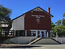
The first school to open in Bayswater was Bayswater Primary School, which was established in 1894 as the Bayswater State School, and is located on Murray Street, near the Bayswater town centre. It caters to 60 Kindergarten students, and 370 students between Pre-Primary and Year 6 as of 2020. It became an independent public school in 2020.[58] The school is listed on the City of Bayswater Local Heritage Survey.[40]
In 1936, St Columba's School, a private catholic primary school opened to students. It located on Roberts Street, and caters to almost 500 students from Pre-Kindergarten to Year 6.[59] The church located on the site is listed on the City of Bayswater Local Heritage Survey.[40]
The third school, and second public school to open in Bayswater was Hillcrest Primary School, which opened in 1962. It is located on Bay View Street, on the crest of a large hill. It caters to 61 Kindergarten students, and 364 Pre-Primary to Year 6 students as of 2020. It became an independent public school in 2020.[60] The school is listed on the City of Bayswater Local Heritage Survey.[40]
In 1985, Durham Road School opened in Bayswater. The school caters to students with intellectual and physical disabilities from Kindergarten to Year 12, serving students from all over Perth. The school had 200 students as of 2020.[61]
There are no secondary schools in Bayswater, but parts of the suburb are in the local intake areas for John Forrest Secondary College and Hampton Senior High School, both of which are independent public schools in Morley for students in Years 7 to 12. Also, just north of the suburb boundary with Bedford is Chisholm Catholic College, a private catholic high school.
Governance
Local
Bayswater is in the City of Bayswater local government area. It lies mostly within the City's west ward, although there is a small portion of the suburb within its central ward.[2] Councillors for the west ward are Lorna Clarke, Giorgia Johnson and Dan Bull, who is also the mayor. Councillors for the central ward are Barry McKenna, Sally Palmer and Steven Ostaszewskyj.[62] Between 1897 and 1983, the suburb of Bayswater was the council seat of the City of Bayswater, which was known then as the Bayswater Road Board and later as the Shire of Bayswater.[4]
State
Bayswater west of Tonkin Highway is within the Electoral district of Maylands, and east of Tonkin Highway is within the Electoral district of Bassendean for the Western Australian Legislative Assembly.[63] Both of these districts are strong seats for the centre-left Labor Party. Labor has held Maylands since 1968 and Bassendean since it was created in 1996. Maylands' current member is Lisa Baker, and Bassendean's current member is Dave Kelly.[64][65] In the Western Australian Legislative Council, both these districts are part of the East Metropolitan electoral region.
Bayswater has two polling locations: The Senior Citizens Centre and Hillcrest Primary School. The results below combine the results of these two polling places.
|
|
|
|
| ||||||||||||||||||||||||||||||||||||||||||||||||||||||||||||||||||||||||||||||||||||
Federal
Bayswater is within the Division of Perth in the Australian Federal Government.[71] It is a safe seat for the Australian Labor Party, and has been held by a Labor member since 1983. Its current member is Patrick Gorman. The results below combine the results of Bayswater's two polling places, Hillcrest Primary School and the Senior Citizens Centre.
|
|
|
| ||||||||||||||||||||||||||||||||||||||||||||||||||||||||||||||||||||||||
|
|
|
| ||||||||||||||||||||||||||||||||||||||||||||||||||||||||||||||||||||||||
Transport
Cars are the most popular mode of transport in Bayswater. The 2011 Census said that 62.9% of residents travelled to work in a car. However, bicycle and public transport usage is significantly above the state average. 15.6% of Bayswater Residents saying that they take public transport to work; the state average is 9.4%, and 2.7% ride a bicycle to work; the state average is 1.1%.
Road
The arterial roads which service Bayswater are Tonkin Highway, Guildford Road, Beechboro Road North, Garratt Road and Grand Promenade. Tonkin Highway is a north–south controlled access highway. Heading north on Tonkin Highway leads to Ellenbrook (20 km) and Joondalup (32 km) via Reid Highway. Heading south, the Redcliffe Bridge carries Tonkin Highway over the Swan River, which leads to Perth Airport, Armadale (33 km) and Roe Highway. The only other bridge over the Swan River in Bayswater is Garratt Road Bridge, which leads to Ascot and Belmont (6 km). Heading south-west on Guildford Road leads to Maylands and the Perth Central Business District (CBD) (6 km). Heading north-west on Guildford Road leads to Bassendean (4 km), Guildford (7 km) and Midland (11 km). Grand Promenade heads north-west of Bayswater and connects to Alexander Drive, Morley Drive and Dianella. Beechboro Road North heads north of Bayswater, leading to Beechboro and Malaga.
Local distributor roads in Bayswater include Beechboro Road South, Collier Road, Coode Street, King William Street, Walter Road East and Whatley Crescent. Whatley Crescent goes through the town centre and connects to Guildford Road west of Bayswater as another connection to the Perth CBD. Collier Road connects the Bayswater industrial area to Tonkin Highway and Guildford Road, as well as linking Bayswater to the Morley commercial precinct. Beechboro Road South connects the town centre and the industrial area to Broun Avenue north of Bayswater.
King William Street is the main street through the town centre, and is the most direct connection between the town centre and Guildford Road. Coode Street connects the town centre to Morley in the north. King William Street and Coode Street connect by an underpass under the railway line. The rail bridge at the underpass has been named the Bayswater Bridge by locals, and is notorious for tall vehicles hitting it. There are three other railway line crossings in Bayswater. They are, from east to west, a level crossing connecting Railway Parade and Guildford Road, a bridge carrying Tonkin Highway over the railway line and a bridge connecting Railway Parade and Whatley Crescent near Meltham Station. There are four crossings of Tonkin Highway in Bayswater, two of which have an interchange with Tonkin Highway. They are, from north to south, Collier Road, which bridges over the highway and connects as a single-point urban interchange, Railway Parade, which passes under a bridge, Guildford Road, which passes under a bridge and connects as a folded diamond interchange, and Dunstone Road, a minor road which passes under a bridge.
Train
Bayswater is serviced by Bayswater railway station and Meltham railway station on the Midland railway line, with commuter services operated by Transperth between Midland and Perth. The currently under construction Airport railway line branches off from the Midland line in Bayswater. When it opens in 2021, it will connect Bayswater to Perth Airport and Forrestfield. In addition, the Morley–Ellenbrook railway line is currently under planning, set to branch off from the Midland line at Bayswater too. It is scheduled to open in 2023, creating a public transport connection between Bayswater and Perth's outer north-eastern suburbs. As part of the Morley-Ellenbrook line project, Morley railway station is set to be constructed just north of Bayswater, which will improve public transport coverage to north-eastern parts of the suburb when it opens. Whatley railway station, which was located in the eastern part of Bayswater near the intersection of Wyatt Road and Higgins Way, was demolished in 1957 following the closure of the Belmont railway line in 1956.
Bus
Transperth bus services in Bayswater include routes 41, 48, 55, 341, 342, 955, 998 and 999. They are operated by Path Transit under contract from Transperth. Path Transit also operates a bus depot in Bayswater. Routes 41, 48 and 55 heading south-west lead to the Perth CBD. In Bayswater, route 41 travels along local streets south of Guildford Road before it loops back around at Leake Street. Route 48 travels along Guildford Road and King William Street, connecting to Bayswater railway station. North of there, route 41 links to Morley bus station, traversing several minor roads along the way. Route 55 travels down Guildford Road and links to Bassendean railway station.[87] Routes 341 and 342 traverse the northern boundary of Bayswater at Walter Road. To the west, they connect to Morley bus station. To the east, they connect to Bassendean railway station and several north-eastern suburbs, including Beechboro.[88] Route 955 travels along Collier Road. To the west, it connects to Morley bus station. To the east, it connects to Bassendean railway station, before heading north to Ellenbrook.[89] Routes 998 and 999, also known as the CircleRoute are a pair of high frequency bus routes which roughly travel in a circle around Perth. Their route through Bayswater consists of Garratt Road, Guildford Road, King William Street and Coode Street. They have a connection at Bayswater railway station. 998 travels south through Bayswater, and 999 travels north through Bayswater. The CircleRoute provides a connection to Morley bus station, Dianella Plaza and Stirling railway station to the north, and Ascot Racecourse, Belmont Forum and Oats Street railway station to the south.[90]
Cycling
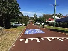
Bayswater is well connected by Principal Shared Paths (PSP's). The Midland Railway Line has a PSP alongside it, which leads to the Perth CBD to the west, and Midland to the east.[91] Tonkin Highway has a PSP alongside it north of Railway Parade, constructed in 2017 as part of NorthLink WA.[92][93] There is also a PSP along the river which is used for recreational cycling.
In 2015, Leake and May Streets were selected to become Perth's first bike boulevard. The speed limit on the bike boulevard is 30 km/h (19 mph), below the standard 50 km/h (31 mph) limit in Australia. Cars are made to slow down by traffic calming measures. The bike boulevard was made to encourage cycling in the area, by linking the river, Bayswater Primary School and the Perth–Midland PSP.[94] The bike boulevard was opened in March 2017.[95] In April 2018, the City of Bayswater decided to not go ahead with stage two of the bike boulevard, which would have seen the bike boulevard extended north through Bedford and Morley.[96]
References
- "2016 Census QuickStats: Bayswater". Census Data. Australia Bureau of Statistics. Retrieved 27 June 2017.
- "Suburb Profiles" (PDF). City of Bayswater. Retrieved 23 August 2020.
- "Indigenous history of the Swan and Canning rivers" (PDF). Department of Parks and Wildlife. Retrieved 9 January 2021.
- "Bayswater Thematic Framework April 2020". City of Bayswater. Retrieved 23 August 2020.
- "The West Australian, Saturday, April 5, 1930". Trove. Retrieved 9 January 2021.
- "The City's Logo". City of Bayswater. Retrieved 9 January 2021.
- "The History of Bayswater, Part I: c50,000 BCE – 1929". City of Bayswater. Retrieved 25 June 2017.
- Lim, Kristie. "Proposed Meltham suburb rename in the works". PerthNow. Retrieved 22 August 2020.
- "History of the name "Meltham"". City of Bayswater. Retrieved 22 August 2020.
- "Bayswater Local History" (PDF). City of Bayswater. Archived from the original (PDF) on 1 April 2018. Retrieved 25 June 2017.
- "History – Part Two: 1930 – present". City of Bayswater. Retrieved 25 June 2017.
- "Structure Plan for Bayswater - November 2015". Engage Bayswater. Retrieved 20 October 2020.
- "Bayswater Town Centre Structure Plan". City of Bayswater. Retrieved 20 October 2020.
- "Draft Structure Plan to Council". Engage Bayswater. Retrieved 20 October 2020.
- "Have your say on the Draft Structure Plan". Engage Bayswater. Retrieved 20 October 2020.
- "New METRONET East Redevelopment Area to help create vibrant centres". Media Statements. Retrieved 20 October 2020.
- Young, Emma. "State to wrest control from Bayswater, Kalamunda councils' Metronet areas". WA Today. Retrieved 20 October 2020.
- "New METRONET precincts to unlock potential of Perth's east". Media Statements. Retrieved 20 October 2020.
- Pascual Juanola, Marta. "Why one Perth council has heritage listed its entire town centre". WA Today. Retrieved 20 October 2020.
- "New plan for Bayswater Town Centre sets vision for growth". Mirage News. Retrieved 19 October 2020.
- "New plan for Bayswater Town Centre sets vision for growth". Media Statements. Retrieved 19 October 2020.
- "Meltham Suburb". Engage Bayswater. Retrieved 22 August 2020.
- "Locals happy with height for trees". The Perth Voice Interactive. Retrieved 22 August 2020.
- "Bayswater!". The Herald. 4 July 1885. p. 2. Retrieved 3 December 2017.
- "Perth suburb names". Landgate. Retrieved 25 June 2017.
- "Metropolitan Region Scheme Map 16" (PDF). Department of Planning, Lands and Heritage. Retrieved 19 October 2020.
- "Geomorphology of Swan Coastal Plain". Garry Middle. Retrieved 23 August 2020.
- "Swan Coastal Plain - Reading". Earth Science WA. Retrieved 23 August 2020.
- "Bayswater Brook Local Water Quality Improvement Plan" (PDF). Department of Water and Environmental Regulation. Retrieved 29 August 2020.
- "Bayswater Brook" (PDF). Department of Water and Environmental Regulation. Retrieved 29 August 2020.
- "Bayswater Brook Brochure" (PDF). Urban Bushland Council WA Inc. Retrieved 29 August 2020.
- "Bayswater Brook Catchment". City of Bayswater. Retrieved 29 August 2020.
- "Eric Singleton Bird Sanctuary". City of Bayswater. Retrieved 29 August 2020.
- "Eric Singleton Bird Sanctuary". Urban Bushland Council WA Inc. Retrieved 29 August 2020.
- "Gobba Lake". City of Bayswater. Retrieved 29 August 2020.
- Lim, Kristie. "City of Bayswater plan to improve Swan River foreshore". Perth Now. Retrieved 29 August 2020.
- "2011 Census QuickStats: Bayswater". Census Data. Australian Bureau of Statistics. Retrieved 27 June 2017.
- "2006 Census Quickstats: Bayswater". Census Data. Australian Bureau of Statistics. Retrieved 27 June 2017.
- "2001 Census QuickStats: Bayswater". Census Data. Australian Bureau of Statistics. Retrieved 27 June 2017.
- "Local Heritage Survey". City of Bayswater. Retrieved 10 January 2021.
- "Baigup Wetlands". Urban Bushland Council WA Inc. Retrieved 10 January 2021.
- "Rowing and Yachting". City of Bayswater. Retrieved 10 January 2021.
- "Riverside Gardens". City of Bayswater. Retrieved 10 January 2021.
- "The Best Dog Beaches in Perth". So Perth. Retrieved 10 January 2021.
- "Autumn River Festival". The Perth Voice Interactive. Retrieved 10 January 2021.
- Lim, Kristie. "City of Bayswater to host annual Avon Descent Finish Line event at Riverside Gardens". Perth Now. Retrieved 10 January 2021.
- "Ellis House Community Art Centre". Ellis House Community Art Centre. Retrieved 28 June 2017.
- "Ellis House - Historical Site". City of Bayswater. Retrieved 28 June 2017.
- "Eric Singleton Bird Sanctuary". Urban Bushland Council WA Inc. Retrieved 10 January 2021.
- "Claughton Reserve". City of Bayswater. Retrieved 10 January 2021.
- "Frank Drago Reserve". City of Bayswater. Retrieved 10 January 2021.
- Hancock, Peter. "Bayswater Growers' Market". Weekend Notes. Retrieved 10 January 2021.
- Prestipino, David. "Fresh Bites: Oktoberfest comes to town, Pirate Life brewery to open in Perth". WAtoday. Retrieved 10 January 2021.
- "Halliday Park". City of Bayswater. Retrieved 10 January 2021.
- "Bayswater War Memorial & Memorial Rose Gardens". Heritage Council of WA. Retrieved 10 January 2021.
- "Lower Hillcrest Reserve". City of Bayswater. Retrieved 10 January 2021.
- "Upper Hillcrest Reserve". City of Bayswater. Retrieved 10 January 2021.
- "Bayswater Primary School (5031)". Schools Online. Retrieved 23 August 2020.
- "History". St Columba's School. Retrieved 23 August 2020.
- "Hillcrest Primary School (5209)". Schools Online. Retrieved 23 August 2020.
- "Durham Road School (6029)". Schools Online. Retrieved 23 August 2020.
- "Elected Members". City of Bayswater. Retrieved 28 August 2020.
- "Find Your Electorate". Electoral Boundaries WA. Retrieved 16 July 2017.
- "Maylands". ABC News. Retrieved 16 July 2017.
- "Bassendean". ABC News. Retrieved 16 July 2017.
- "Maylands District Profile and Results". Western Australian Electoral Commission. Retrieved 28 August 2020.
- "Maylands District Profile and Results". Western Australian Electoral Commission. Retrieved 28 August 2020.
- "Maylands District Profile and Results". Western Australian Electoral Commission. Retrieved 28 August 2020.
- "Maylands District Profile and Results". Western Australian Electoral Commission. Retrieved 28 August 2020.
- "SGE_DistrictProfiles_Alb-Avn" (PDF). Western Australian Electoral Commission. Retrieved 28 August 2020.
- "Locality Search". Australian Electoral Commission. Retrieved 25 June 2017.
- "Bayswater - polling place". Australian Electoral Commission. Retrieved 28 August 2020.
- "Bayswater North - polling place". Australian Electoral Commission. Retrieved 28 August 2020.
- "Bayswater - polling place". Australian Electoral Commission. Retrieved 28 August 2020.
- "Bayswater North - polling place". Australian Electoral Commission. Retrieved 28 August 2020.
- "Bayswater - polling place". Australian Electoral Commission. Retrieved 28 August 2020.
- "Bayswater North - polling place". Australian Electoral Commission. Retrieved 28 August 2020.
- "POLLING PLACE - BAYSWATER". Australian Electoral Commission. Retrieved 28 August 2020.
- "POLLING PLACE - BAYSWATER NORTH". Australian Electoral Commission. Retrieved 28 August 2020.
- "POLLING PLACE - BAYSWATER". Australian Electoral Commission. Retrieved 28 August 2020.
- "POLLING PLACE - BAYSWATER NORTH". Australian Electoral Commission. Retrieved 28 August 2020.
- "POLLING PLACE - BAYSWATER". Australian Electoral Commission. Retrieved 28 August 2020.
- "POLLING PLACE - BAYSWATER NORTH". Australian Electoral Commission. Retrieved 28 August 2020.
- "POLLING PLACE - BAYSWATER". Australian Electoral Commission. Retrieved 28 August 2020.
- "POLLING PLACE - BAYSWATER NORTH". Australian Electoral Commission. Retrieved 28 August 2020.
- "WA : Perth". Australian Electoral Commission. Retrieved 28 August 2020.
- "Bus Timetable 103" (PDF). Transperth. Retrieved 25 June 2017.
- "Bus Timetable 104" (PDF). Transperth. Retrieved 26 August 2020.
- "Bus Timetable 99" (PDF). Transperth. Retrieved 25 June 2017.
- "Bus Timetable 200" (PDF). Transperth. Retrieved 26 August 2020.
- "Perth to Midland Bike Route" (PDF). Department of Transport. Retrieved 15 July 2017.
- "Southern Section". Main Roads Western Australia. Archived from the original on 6 April 2017. Retrieved 15 July 2017.
- "Major Cycle and Pedestrian Paths" (PDF). Bicycling Western Australia. Retrieved 15 July 2017.
- Beattie, Adrian (4 October 2015). "Perth's bicycle boulevards - where cyclists get priority over cars". WA Today. Retrieved 15 July 2017.
- Shakespeare, Toyah (21 March 2017). "Bayswater bike boulevard connects suburb to Morley". Eastern Reporter. Community News. Retrieved 15 July 2017.
- "City of Bayswater flat on enthusiasm for Bayswater to Morley Bike Boulevard project stage 2". Perth Now. Retrieved 26 August 2020.