Ben Bullen, New South Wales
Ben Bullen is a small mountain village in the Central West of New South Wales, Australia. It is located on the Castlereagh Highway (almost) halfway between the small towns of Cullen Bullen and Capertee. In the 2016 census, it recorded a population of 100 people.[1] The place name Ben Bullen is derived from the local Aboriginal word meaning "high, quiet place".[2]
| Ben Bullen New South Wales | |
|---|---|
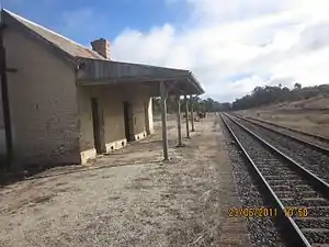 Ben Bullen railway station in 2011 | |
Ben Bullen | |
| Coordinates | 33°13′10″S 150°01′19″E |
| Population | 100 (2016 census)[1] |
| Postcode(s) | 2790 |
| Location | |
| LGA(s) | City of Lithgow |
| State electorate(s) | Bathurst |
| Federal Division(s) | Calare |
The village was formed when the railway was constructed in the early 1880s. While goods trains still use the railway line the small railway station is closed. Since the closure of the railway station a bus service serves the community.
Ben Bullen is surrounded by picturesque cattle grazing land and the Gardens of Stone National Park. Farming and coal mining are the main local employers.
Heritage listings
Ben Bullen has a number of heritage-listed sites, including:
- Wallerawang-Gwabegar railway: Ben Bullen railway station[3]
References
- Australian Bureau of Statistics (27 June 2017). "Ben Bullen (state suburb)". 2016 Census QuickStats. Retrieved 15 April 2018.

- "Ben Bullen". Geographical Names Register (GNR) of NSW. Geographical Names Board of New South Wales. Retrieved 13 June 2009.
- "Ben Bullen Railway Station group". New South Wales State Heritage Register. Office of Environment and Heritage. H01082. Retrieved 18 May 2018.